| SUMMARY
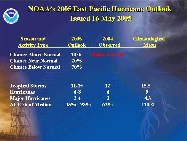
NOAA scientists are forecasting a 70% probability of a below normal tropical eastern North Pacific hurricane season during 2005, a 20% probability of near-normal season, and only a 10% probability of an above-normal season. This outlook is a joint effort of scientists at the National Oceanic and Atmospheric Administration’s (NOAA) Climate Prediction Center (CPC), the Hurricane Research Division (HRD) and the National Hurricane Center (NHC). See Background Information for NOAA’s definitions of above-, near-, and below-normal seasons.
NOAA’s 2005 outlook for the tropical eastern North Pacific hurricane season calls for 11-15 tropical storms (average is 15-16), with 6-8 becoming hurricanes (average is 9), and 2-4 becoming major hurricanes (average is 4-5). This outlook reflects the ongoing multi-decadal signal that has been acting to suppress East Pacific hurricane activity since 1995, combined with the expectation of ENSO neutral conditions during much of the season.
This is NOAA’s first operational outlook for the eastern North Pacific hurricane region, which covers the tropical eastern North Pacific east of 140oW. Prior to this, NOAA issued experimental East Pacific outlooks for both the 2003 and 2004 hurricane seasons. There will be no updates to this outlook.
DISCUSSION
1. Expected Activity - 70% Chance Below Normal, 20% Chance Near Normal, 10% chance Above Normal
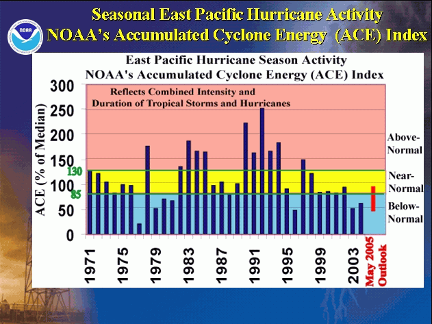
An important measure of total seasonal activity is NOAA’s Accumulated Cyclone Energy (ACE) index, which accounts for the collective strength and duration of tropical storms and hurricanes during a given hurricane season (see Background Information). The ACE index is also used to define the above-, near-, and below-normal seasons. A value of 85% of the median (Median value is 110) corresponds to the upper boundary for a below-normal season.
For the 2005 tropical eastern North Pacific hurricane season, the ACE index is expected to be 45%-95% of the median. The main climate signals for this prediction include a) the ongoing multi-decadal signal that has favored generally below-normal seasonal activity since 1995, and c) ENSO-neutral conditions throughout the season. The ongoing trend of reduced eastern North Pacific hurricane activity since 1995 is coincident with generally above-normal Atlantic hurricane activity.
The 2005 East Pacific hurricane season is expected to bring 11-15 tropical storms, with 6-8 becoming hurricanes, and 2-4 becoming major hurricanes {categories 3-4-5 on the Saffir-Simpson scale}. This outlook reflects the expectation that many of the named storms will remain relatively weak, and that the hurricanes and major hurricanes will be shorter-lived compared to normal. While it is reasonable to expect this range of tropical storms, hurricanes, and major hurricanes, the total seasonal activity measured by the ACE index can certainly be in the expected range without all three of these criteria being met.
Most tropical storms that form in the eastern North Pacific track westward into open waters, sometimes reaching Hawaii and beyond. An additional one to two tropical storms either head northward or recurve toward western Mexico, and influence the summer precipitation amounts there. Regardless of their track East Pacific tropical storms and hurricanes can supply much needed moisture to the arid southwestern United States.
CAUTIONARY NOTES
1) It is important to recognize that it is currently not possible to confidently predict at these extended ranges the number or intensity of land falling hurricanes, or whether a particular locality will be impacted by a hurricane this season. Therefore, residents and government agencies coastal and near?coastal regions should always maintain hurricane preparedness efforts regardless of the overall seasonal outlook.
2) Far more damage can be done by one major hurricane hitting a heavily populated area than by several hurricanes hitting sparsely populated areas or, of course, not making landfall at all. Therefore, hurricane?spawned disasters can occur even in years with near?normal or below?normal levels of activity.
NOAA FORECASTERS
NOAA's Climate Prediction Center
Dr. Muthuvel Chelliah, Physical Scientist, Muthuvel.Chelliah@noaa.gov
Dr. Gerald Bell, Meteorologist, Gerry.Bell@noaa.gov
Dr. Kingtse Mo, Physical Scientist, Kingtse.Mo@noaa.gov
NOAA's Hurricane Research Division
Dr. Christopher Landsea, Meteorologist, Chris.Landsea@noaa.gov
NOAA's National Hurricane Center
Eric Blake, Meteorologist, Eric.S.Blake@noaa.gov
|


