|
Discussion
The evolution towards a warm (El Niño)
episode continued in the equatorial Pacific during March 2002. Warmer-than-normal sea
surface and subsurface temperatures were observed throughout most of the equatorial
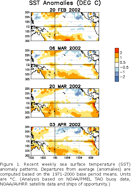
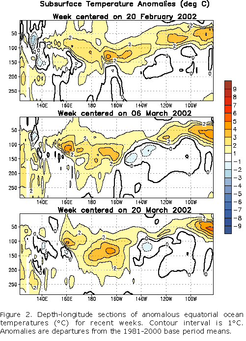
Pacific (Fig. 1 and Fig. 2,
respectively). An area of equatorial sea surface temperature anomalies exceeding +1°C
continued to expand westward from the South American coast during the month (Fig. 1). Ocean surface temperatures remained as much as 2-3°C (up
to 6°F) above average near the coasts of Ecuador and northern Peru. This warming has been
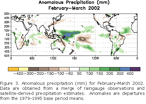
accompanied by an increase in rainfall over the extreme eastern tropical Pacific,
including the Galapagos Islands since late February 2002 (Fig. 3).
Parts of western South America (Ecuador and northern Peru) are also experiencing impacts
due to the above normal sea surface temperatures in the far eastern tropical Pacific. This
warming has affected Peruvian marine fisheries, where the cold water anchovy has been
replaced by tropical species. Persistent rain and cloudiness have also been observed over
the tropical west-central Pacific, from Papua New Guinea eastward to the date line
(180°W) since late December 2001. It is likely that these conditions represent the early
stages of El Niño and that mature El Niño conditions will take at least several
more months to develop. Several of the atmospheric indices, including both
lower-tropospheric and upper-tropospheric wind indices, do not reflect El Niño/ Southern
Oscillation (ENSO) conditions at this time. However, these indices are often inconsistent
in the early stages of El Niño.
The warming of surface and subsurface waters in the eastern equatorial Pacific was due
to the arrival of an oceanic Kelvin wave that propagated eastward from the central
equatorial Pacific starting in mid-December. The Kelvin wave was triggered by tropical
intraseasonal (30-60 day) fluctuations associated with the Madden-Julian Oscillation
(MJO). Whereas MJO activity was evident throughout the global tropics during much of the
NH winter, MJO activity was not apparent during March 2002. However, the period from now
thru May is a critical time, when MJO-related westerly wind bursts or other short-lived
westerly wind activity can generate Kelvin waves. Without such activity a continued slow
evolution towards mature El Niño conditions would be expected to occur through the spring
and summer of 2002. With such activity a more rapid evolution might occur.
The latest statistical and coupled model predictions show a spread from near-normal
conditions to moderate warm-episode conditions during the remainder of 2002. The coupled
models and some statistical techniques that incorporate subsurface oceanic conditions
indicate a slow evolution to weak or moderate warm-episode (El Niño) conditions during
the next several months. Other techniques indicate that conditions will remain near normal
or even return to slightly colder than normal for the remainder of 2002. Based on the
recent evolution of the observed oceanic conditions and the SST predictions, it appears
most likely that further development toward mature El Niño conditions will occur over the
next 3-9 months. A projection of the ultimate strength of the El Niño and the magnitude
of the associated impacts may be possible in late spring 2002.
This discussion is a team effort of NOAA and its
funded institutions. Updates of SST, 850-hPa wind, OLR and the equatorial subsurface
temperature structure are available on the Climate Prediction Center web page at
http://www.cpc.ncep.noaa.gov (Weekly Update). Forecasts for the evolution of
El Niño/La Niña are updated monthly in CPC's Climate Diagnostics Bulletin Forecast Forum. To receive
an e-mail notification when updated ENSO Diagnostic Discussions are released please send
your e-mail address to:
|


