|
General: During El Nino, rainfall and thunderstorm activity diminishes over the western equatorial Pacific, and increases over the eastern half of
the tropical Pacific. This area of increased rainfall occurs where the exceptionally warm ocean waters have reached about 28°C or 82°F. This overall
pattern of rainfall departures spans nearly one-half the distance around the globe, and is responsible for many of the global weather impacts
caused by El Niño.
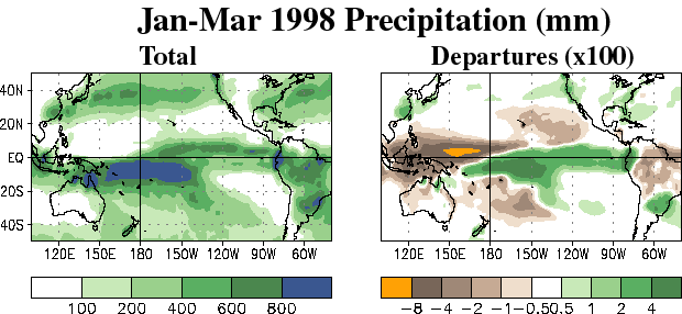
Detailed: In the left-hand panel the seasonal rainfall totals during the strong El Niño conditions of January-March 1998 are shown for over the
Pacific Ocean, the United States, and South America. The heaviest rainfall [in units of millimeters (mm)] is shown by the darker green and blue
colors, and lowest rainfall is shown by the lighter green colors. Since 25.4 mm is equal to one inch of rain, we see that the rainfall totals are more
than 800 mm just south of the equator along the International Date Line (indicated by the 180 label), which is more than 31 ½ inches of rain.
And nearly double the normal amount.
In the right-hand panel the January-March 1998 seasonal rainfall departures from average are shown. The areas with well above average rainfall
are shown by darker green colors, and the areas with well below-average rainfall are shown by the darker brown and yellow colors. The rainfall
departures are shown in units of 100 millimeters. We see that the seasonal rainfall totals were more than 400 mm above normal just south of the
equator along the International Date Line (indicated by the 180 label), which is more than 15 ¾ inches above normal. Considerable rainfall also
occurred farther north (near 40°N) over the central and eastern North Pacific, and across the western and southeastern United States. These areas
lie along the main wintertime storm track, which brings above-average rainfall to the western and southeastern United States.
In contrast, the seasonal rainfall totals over the western Pacific just north of the equator were less than 100 mm during the season (see left-hand
panel), which is more than 800 mm (or 31 1/2) inches) below normal. This extreme dryness led to a series of major uncontrolled wildfires in
Indonesia.
|