
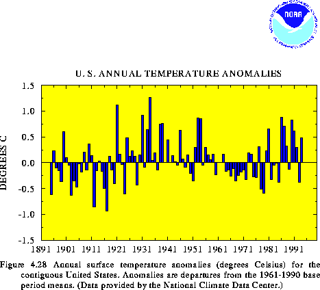
According to preliminary estimates, the mean annual surface temperature over the contiguous United States during 1994 was 0.48C above the long-term mean (Fig. 4.28). Thus, 1994 ranked as the 16th warmest year on record since 1895. More than 25% of the nation recorded annual temperatures in the upper 10th percentile during the year, while none of the country recorded significantly colder-than-normal conditions. The warmth was found mainly in the West, which averaged in the upper one-third of the 100-year historical record. In contrast, near-normal temperatures covered much of the country east of the Mississippi River. Above-normal temperatures have dominated the United States during the past 9 years (Fig. 4.28), although temperatures during 1993 averaged much below normal.
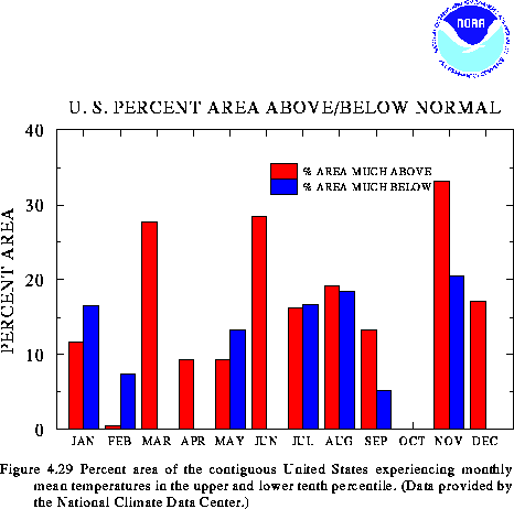
On a monthly basis, above-normal temperatures dominated large parts of the country during March, June, and December, while unusually cold conditions were observed in February (Fig. 4.29). Remarkably, no regions experienced significantly below-normal temperatures during March, April, June, October, and December. October was unusual in that virtually none of the contiguous United States experienced either much-above or much-below temperatures.
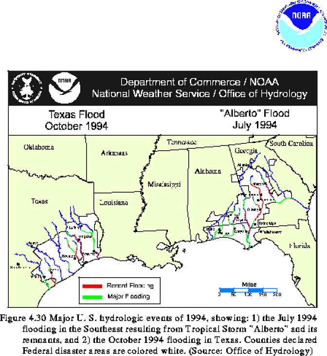
Two major flood events dominated the precipitation anomalies during 1994. The first event occurred in July, when tropical storm Alberto crossed the Florida Panhandle. Maximum sustained winds peaked at 29 m/s at the time of landfall on July 3. The storm caused torrential rainfall throughout the eastern Gulf coast region, with the largest totals exceeding 700 mm at Americus, Georgia. Record flooding was observed along portions of several large river systems in Georgia, Alabama, and Florida (Fig. 4.30) during the storm, and damages were estimated at $750 million, including at least $100 million in agricultural losses.
The second event occurred in southeastern Texas during mid-October, in association with sustained tropical rainfall focused along a stationary frontal zone. Local totals exceeded 750 mm, and much of southeastern Texas recorded more than 150 mm during this period. Record flooding occurred along six major rivers and their tributaries (Fig. 4.30), and damages were estimated in the hundreds of millions of dollars.
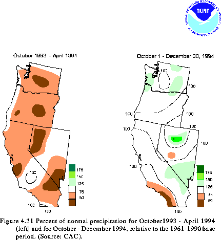
In the western United States, the 1993-94 wet season brought below-normal precipitation (less than 50% of normal) to large portions of Washington, Oregon, California and Nevada (Fig. 4.31, left). Intermittent severe-to-extreme drought conditions have persisted over large parts of the Pacific Northwest and California during the past decade.
During the onset of the 1994-95 wet season (Oct - Dec), precipitation averaged above normal over much of Washington, Oregon, Nevada, and California (Fig. 4.31, right) and was substantially larger than observed during the past several years. Additionally, heavy snow fell over large portions of western Washington, Oregon, and northern California during October-December 1994, resulting in a much above-normal snowpack water content throughout these regions. This precipitation helped to significantly alleviate drought conditions over large parts of the West.
![]() Regional Climate Summaries: US Highlights - Tornado Activity
Regional Climate Summaries: US Highlights - Tornado Activity
![]() Regional Climate Summaries: European Heat Wave
Regional Climate Summaries: European Heat Wave
![]() Table of Contents
Table of Contents


