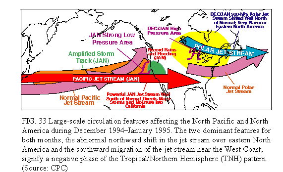
1) December 1994-January 1995: Wet in Western U. S., warm in East
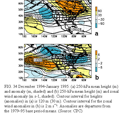
The 1994/95 winter season brought abnormal weather conditions to large portions of North America. These conditions were particularly acute from mid-December 1994 through the end of January 1995. California and much of the western and southwestern United States received significantly above-normal precipitation during the period, while both the western United States and the eastern half of North America experienced record or near-record warmth. These conditions are attributed to a persistent and abnormal atmospheric circulation (Fig. 33), characterized in the West by below-normal upper-air heights and surface pressure and a southward shift of the jet stream, and in the East by above-normal upper-air heights and surface pressure and a northward shift of the jet stream (Figs. 33, 34).
In the West, this circulation was associated with an eastward extension of the jet core from Asia to central California. This jet stream served as a "duct" for major storm systems which were directed across the Pacific and into California, thus producing excessive precipitation and flooding throughout the state. During January, this jet core and storm track were displaced south of their normal location by approximately 18° latitude in the vicinity of the West Coast.
Farther east, the polar jet stream was shifted northward to south of James Bay, approximately 15° latitude north of normal. This flow pattern prevented the normal build up of cold air over central and western Canada and also tended to direct any cold-air masses quickly across eastern Canada and then out over the western Atlantic. These conditions, in combination with abnormally strong southwesterly flow farther south, brought extreme warmth to the eastern half of the United States and much of southern Canada during the period.
This circulation pattern reflected the most pronounced negative phase of the Tropical/ Northern Hemisphere (TNH) teleconnection pattern in the historical record dating back to 1964. A negative TNH pattern is common during the mature phase of warm El Niño/Southern Oscillation (ENSO) episodes (Mo and Livezey 1986). Thus, the establishment of this pattern during the 1994/95 winter season, a period dominated by mature-phase, warm ENSO conditions (see section 3), was not unusual. Recent studies (Bell and Kousky 1996) indicate a strong linkage between the occurrence of mature ENSO conditions during the 1994/95 winter and the highly anomalous circulation features observed throughout the North Pacific and North American sectors.
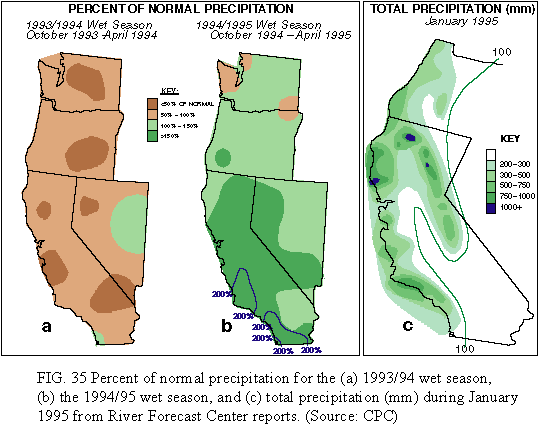
In the western United States the bulk of the annual precipitation falls during the October_April wet season. During the past ten years, below-normal precipitation has been observed over much of the region. In particular, the 1993/94 wet season was very dry throughout the West (Fig. 35 a), so that by the beginning of the 1994/95 wet season, long-term drought was firmly entrenched throughout the region. These drought conditions lessened between October and December 1994 as near-normal precipitation covered the West, and they completely disappeared by the end of January 1995 in association with significantly above-normal precipitation during the month. The California Department of Water Resources reported that through late January, the snowpack in the northern Sierra Nevada Mountains exceeded the record January 1983 values, while the snowpack in the central and southern Sierras was almost as large as the record observed during January 1983.
According to the River Forecast Centers, the heaviest precipitation during January 1995 (950-1050 mm) fell on the southern Cascades, the northern Sierra Nevada, the windward slopes near Santa Rosa (north of San Francisco), and at Old Man Mountain near Santa Barbara (Fig. 35c). In southern California, intense periods of heavy rain and snow were observed during January, while farther north nearly continuous precipitation was observed. For example, most of northern and central California observed precipitation on all but 4-5 days during the month, and San Francisco established a new record for consecutive days with measurable precipitation during 1-16 January. Elsewhere, Mt. Shasta and Santa Rosa recorded precipitation for a record 29 days during January. In general, the excessive January precipitation, in conjunction with very heavy rainfall during March, brought October-April totals to near-normal or above-normal over most of Washington, Oregon, Idaho, Nevada, and California, with at least twice the normal seasonal total recorded in parts of southern California (Fig. 35b).
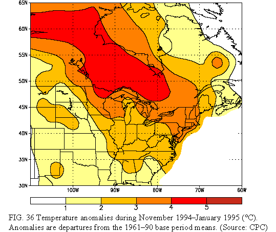
Farther east, unusually mild weather dominated eastern North America from November 1994 through January 1995 (Fig. 36). During this period, temperatures averaged 4°-5°C above normal over large portions of east-central Canada, and 2°-4°C above normal throughout the rest of east-central and southeastern Canada and the Great Lakes region. More than 250 record high temperatures were established across the northern and eastern sections of the United States during this 3-month period. According to the National Climatic Data Center, November-January statewide-average temperatures for 1994 /95 were the highest on record in New Hampshire and Vermont. Furthermore, it was one of the five warmest November-January periods in the 100 years of record in 14 other states [MD (2), NJ (2), NY (2), PA (2), RI (2), CT (3), OH (3), MA (4), MI (4), WI (4), KY (5), MN (5), VA (5), WV (5)].
Accompanying these extremely warm conditions, abnormally low snow cover was observed throughout the Great Lakes region and the northeastern United States. By late January, much of the Northeast had snowfall deficits exceeding 30 cm, while some regions of central New York and southwestern New England experienced 75-120 cm less than normal snowfall.
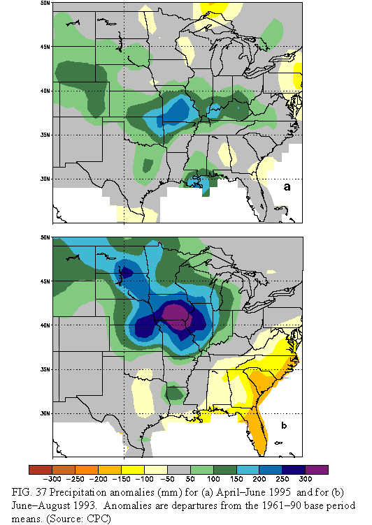
From early April through mid-June 1995, surplus precipitation covered much of the Midwest, the Plains States, and the lower Ohio Valley (Fig. 37a). The eastern Dakotas, the central Gulf Coast, and an area from central Kansas eastward to the western Ohio Valley received 2 to 3 times their normal precipitation for the period, with many sections receiving 450-750 mm of precipitation. The largest totals were observed in eastern Oklahoma and Kansas, southwestern and central Missouri, southern Illinois and Indiana, and central Kentucky. Despite some very large amounts, the areas receiving excessive precipitation were highly variable from one storm to the next and were stretched along an axis extending from the south-central Great Plains northeastward into the lower Ohio Valley. Most of the above areas also received surplus rains during the 1993 Midwest Flood (which peaked during July) (Fig. 37b), as did northern Missouri, Iowa, southern Minnesota, and the Dakotas . Indeed, 750-1000 mm of rain fell on some locations during the summer of 1993 as one major rainfall event after another affected the same regions.
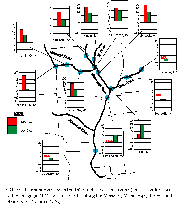
Much of both the lower and middle Missouri and Mississippi and lower Ohio Rivers and their tributaries flooded at least briefly during April-June 1995 (Fig. 38). This area is primarily to the south and east of the regions most severely affected by river flooding in 1993, namely the middle and upper Mississippi and the middle and lower Missouri Rivers and their tributaries (Fig. 38 ). However, large portions of eastern Kansas, northern and central Missouri, and western Illinois were impacted by both flooding episodes.
Overall, maximum water levels during the 1995 flood approached, but did not reach, those recorded during the 1993 floods along the lower Missouri and middle Mississippi Rivers. To the north and west of this region, flooding was significantly more serious in 1993. Farther south and east, the Mississippi/Missouri confluence experienced significant flooding during 1995 and actually experienced near-normal streamflows during the 1993 flood.
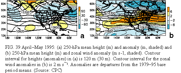
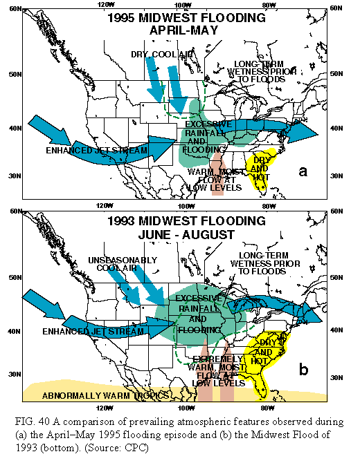
The 1995 floods were directly related to an abnormally strong and persistent southwesterly flow at jet stream level (250 hPa) over the central United States (Figs. 39, 40a), which pushed a series of major storm systems across the country. These storms tapped warm, moist air from over the Gulf of Mexico and produced excessive precipitation totals throughout the Midwest, an area in which soil moisture levels were significantly higher than normal even prior to the onset of the floods.
There are many similarities in the atmospheric circulation between the 1993 (Bell and Janowiak 1995; Mo et al. 1995) and 1995 flood events (Fig. 40). These include 1) an ENSO-induced, southeastward shift of the mean jet stream position over the northern Pacific Ocean during the Winter and Spring prior to the onset of the events; 2) persistent upper-level troughs over both the western United States and the Canadian Maritime Provinces during the events; 3) an abnormally strong southwesterly flow at jet stream level through the middle of the country during the events, along with an enhanced low-level flow of warm, moist air into the flood region; 4) an unusually active storm track, which triggered a series of major thunderstorm com plexes over the Midwest; and 5) a preconditioning for potentially severe hydrologic problems prior to the onset of the floods in both cases by nearly saturated soil moisture conditions throughout the region.
There are also important differences in the atmospheric circulation between the two flood events. First, the circulation anomalies during April-June 1995 tended to be weaker and somewhat less persistent than those observed during June-July 1993. Second, the moisture-laden southerly flow in the lower atmosphere (850 hPa) over the Midwest during June-July 1993 was stronger and more persistent than during April-May 1995. In July 1993, this extremely strong moisture transport, coupled with a strong, nearly-stationary low-level frontal boundary, allowed for the repetitive formation of major thunderstorm complexes over the Midwest, resulting in prolonged severe flooding throughout the region. Third, substantial variability in the paths of the individual storms during April-June 1995, and in the locations of their accompanying precipitation shields, produced relatively large regional variations in precipitation over the Midwest. In contrast, there was much less spatial variability to the storm track and rain shields in June-July 1993, resulting in inundating rain events repeatedly affecting the same areas.
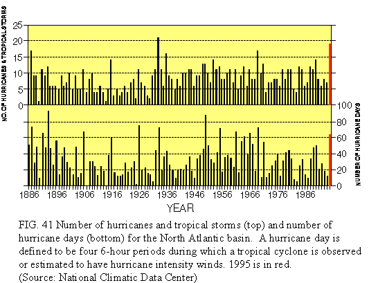
The 1995 Atlantic hurricane season featured 19 tropical storms (Fig. 41), with 11 of these systems reaching hurricane status. This is the second largest number of tropical storms observed in any hurricane season (June-November) since 1871, and the second largest number of hurricanes observed in one season since records began in 1886. On average, 9-10 tropical storms are observed over the North Atlantic between June and November, with 5-6 of these systems typically becoming hurricanes. Interestingly, all but three tropical cyclones formed between August and October, with nine tropical storms developing during the 31-day period between 30 July and 29 August. Of these nine storms, five became hurricanes.
The active 1995 hurricane season follows four consecutive years (1991-94) of extremely low tropical storm and hurricane activity over the North Atlantic (Figs. 41). For example, the 19 tropical storms observed in 1995 is more than twice the total observed during each of the 1991-1994 seasons (6-8 storms). Additionally, the 11 hurricanes during 1995 far exceeds the 3-4 hurricanes observed each year during 1991-94. Landsea et al. (1996) note that the upsurge in hurricane activity during 1995 was most dramatic in the subtropics (equatorward of 25°N, excluding the Gulf of Mexico) where only one hurricane developed during 1991-94. As a result of this increased activity, the countries surrounding the Caribbean Sea were struck by three hurricanes (two being intense hurricanes- Luis and Roxanne) after experiencing a record five years with no hurricanes.
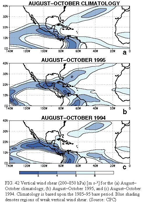
Tropical storms over the North Atlantic, with the exception of the Gulf of Mexico, are generally triggered by easterly waves which propagate off the African mainland and move westward across the Atlantic. However, the potential for the storm intensification is largely controlled by the vertical wind shear; strong vertical shear acts to inhibit intensification, while weak vertical shear acts to aid intensification (Gray 1968). In fact, the most prominent factor controlling the year-to-year variability in tropical storm and hurricane activity over the North Atlantic is the strength of the vertical wind shear.
Climatologically, strong vertical shear is observed throughout the Caribbean, large portions of the subtropical North Atlantic, and the northern Gulf of Mexico (Fig. 42a). These conditions act as a major inhibitor to hurricane activity. Indeed, active hurricane years are typically associated with a pronounced weakening of the vertical shear throughout these regions, as was observed during the 1995 season (Fig. 42b). In particular, minimal vertical wind shear was observed during the 1995 hurricane season throughout the entire region from western Africa to the Gulf of Mexico and the Caribbean Sea (Fig. 42b).
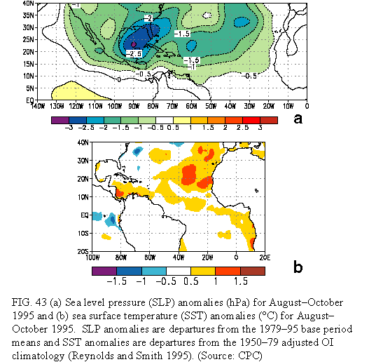
Landsea et al. (1996) noted that other atmospheric and oceanic parameters were also extremely favorable for enhanced tropical storm and hurricane activity during the 1995 season. In particular, below-normal sea level pressure (Fig. 43a) and above-normal sea surface temperatures (Fig. 43b) were observed throughout the western and central subtropical North Atlantic during August-October. These overall conditions, combined with a series of intense easterly waves originating over north-central Africa, provided the primary ingredients for a highly active hurricane season throughout the subtropical North Atlantic basin.
There are apparently strong long-range predictive signals for Atlantic basin seasonal tropical cyclone activity up to 11 months in advance (Gray et al., 1992; Gray et al. 1994a). These signals are associated with three prominent phenomena 1) the El Niño-Southern Oscillation (ENSO) cycle; 2) the stratospheric Quasi_Biennial Oscillation (QBO); and 3) West African rainfall. Gray and colleagues indicated in November 1994 (Gray et al. 1994b) that the above three factors would be in a phase favorable for above-normal Atlantic tropical storm activity during 1995.
The most important identifiable phenomenon associated with year-to-year climate variability is ENSO. During the warm phase of this oscillation, above-normal sea surface temperatures are observed throughout the central and east-central equatorial Pacific. Associated with this increase in ocean temperatures, the normal pattern of tropical cloudiness and precipitation is disrupted, which in turn affects the atmospheric wind and pressure patterns throughout the Northern Hemisphere. In summer, these conditions generally contribute to enhanced vertical wind shear over the North Atlantic, thereby inhibiting hurricane activity.
The mid-1991 through early 1995 period was dominated by warm (ENSO) episode conditions. Important manifestations of these conditions included extremely persistent patterns of strong vertical wind shear and above-normal SLP over much of the subtropical North Atlantic. These conditions apparently contributed to the marked decrease of tropical storm and hurricane activity over the North Atlantic previously noted during the 1991-94 hurricane seasons.
Atmospheric and oceanic conditions throughout the tropical Pacific began a rapid return to normal in March 1995. This evolution marked an end to prolonged warm-episode conditions and also signaled the demise of the anomalous patterns of vertical wind shear and sea level pressure that had previously hindered Atlantic tropical storm development.
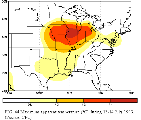
In mid-July dangerously hot and humid conditions spread across most of the central and eastern United States, resulting in nearly 1000 deaths, 500 of which occurred in the Chicago, IL area. During the period daily high temperatures exceeded 40°C as far north as South Dakota and Wisconsin, and dew-point temperatures reached 29°C over large portions of the Midwest. These conditions combined to produce apparent temperatures of 38°-45°C (100°-113°F) (Fig. 44). Additionally, all-time high temperatures were recorded during the event at La Crosse, Wisconsin (42°C, 13 July), Danbury, Connecticut (41°C, 15 July), Chicago/ Midway, Illinois (41°C, 13 July), Chicago/ O'Hare, Illinois (40°C, 13 July), and Flint, Michigan (38°C, 14 July) before a series of weak cold fronts brought relief during the third week in July. However, during August, significantly above-normal temperatures returned to the Midwest, the mid-Atlantic states, and the Northeast, contributing to moderate-to-severe drought conditions throughout the latter two regions, as described below.
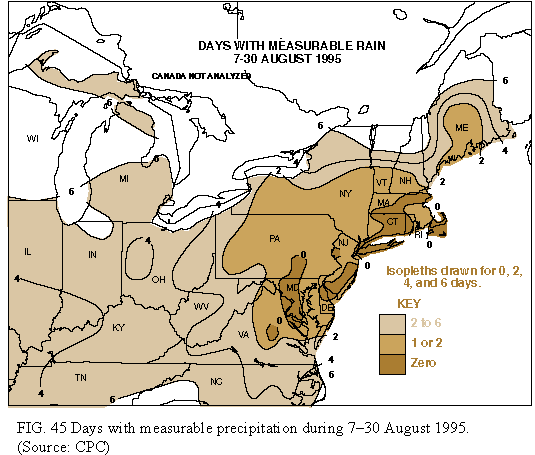
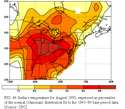
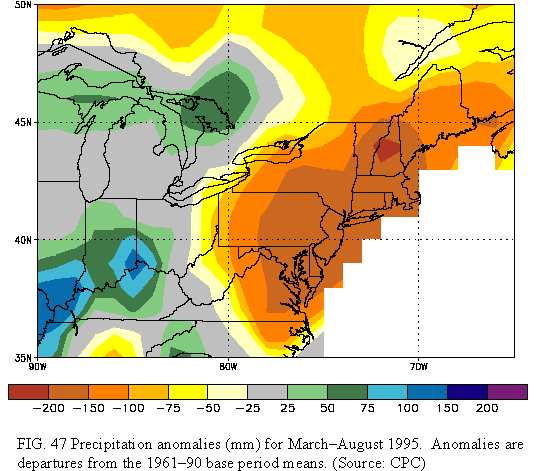
During August moderate-to-severe drought conditions developed across the northeastern quarter of the United States. These conditions developed in response to a combination of severe precipitation deficits (Fig. 45) and excessive heat (Fig. 46) during the month, which acted to exacerbate long-term dryness that had persisted since mid-March (Fig. 47), and in some areas since October 1994. The drought conditions developed after the remnants of Hurricane Erin crossed the mid-Atlantic states on August 6. During the remainder of the month only isolated light showers were observed in most of the Northeast and mid-Atlantic states, with no measurable rain reported in several areas from north-central Virginia northeastward to Massachusetts (Fig. 47).
The drought can be attributed to a large-scale displacement of the upper-level circulation features from their climatological position. Normally, a moderately strong upper-level ridge dominates the central United States during August, with troughs positioned along both the Atlantic and Pacific Coasts. During August 1995 the mean ridge axis was shifted east of normal, and was centered over eastern North America. This flow pattern forced significant midlatitude weather disturbances, along with their attendant cold frontal boundaries and frontal circulations, northward toward central and eastern Canada. The result was abnormally warm and dry conditions throughout the Northeast. These conditions enhanced an overall pattern of subnormal precipitation observed during the previous six to eleven months over much of the Northeast and mid-Atlantic states.
Normally, 400-600 mm of rainfall is measured in the Northeast and eastern mid-Atlantic between mid-March and late-August. However, most of this region recorded less than 75% of normal precipitation during this period in 1995, with localized sections of New York, southern New England, and the eastern mid-Atlantic observing less than half their normal precipitation. For example, only 250-380 mm of precipitation were measured at most locations in the Northeast, with even lesser totals (125-425 mm) recorded in eastern and southeastern New York, northeastern Pennsylvania, and southern Vermont.
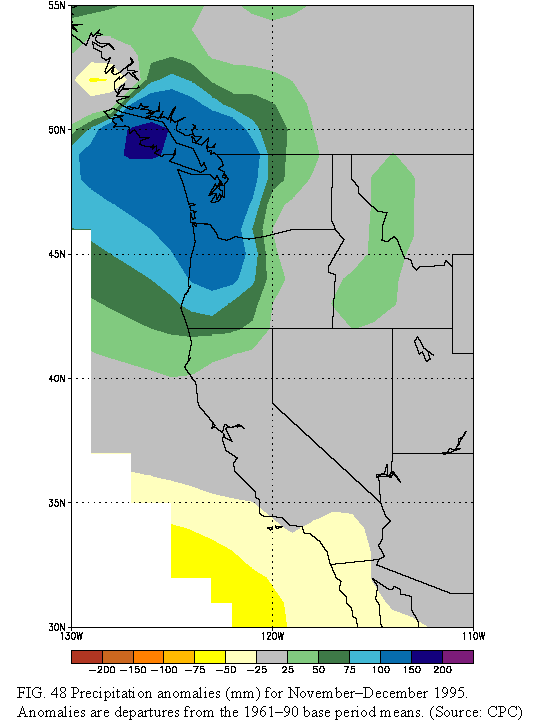
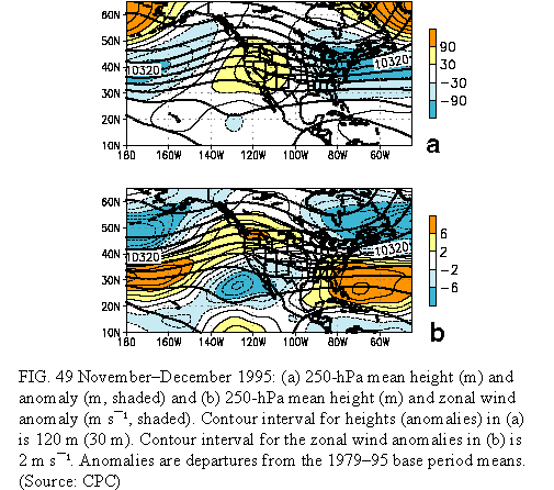
Heavy precipitation (Fig. 48), which fell primarily as rain at all but the highest elevations, dominated the Pacific Northwest states and western Canada during November and December 1995. Rainfall amounts of 200-500 mm fell on parts of western Washington and northwestern Oregon during the period, with one-day totals reaching 125_155 mm. This resulted in severe river flooding, particularly west of the Cascade Mountains.
This heavy rainfall was associated with a persistent pattern of below-normal heights at upper levels (Fig. 49a) over the central North Pacific, and above-normal heights over the western United States. This anomaly pattern was accompanied by enhanced southwesterly flow (Fig. 49 b) extending from the central North Pacific to the Pacific Northwest, resulting in an abnormally strong flood of marine air into the Northwest during the period. This flow pattern also directed a series of strong, fast-moving, moisture-laden storms into the region, which directly the heavy rainfall and flooding conditions.
Farther east, well below-normal surface temperatures dominated the eastern United States during November-December 1995. This persistent cold was associated with an amplification of the climatological mean "Hudson Bay trough" (Fig. 49a), along with enhanced northwesterly flow into the region.
The circulation during November-December 1995 reflected an anomalous, planetary-scale flow pattern that extended from the central North Pacific to eastern Europe and accompanied cold episode conditions in the tropical Pacific. This circulation was in marked contrast to that observed in the Pacific/ North American sector during the previous December-January (DJ94/95) period (see Section 4a), a period when mature ENSO conditions dominated the tropical Pacific (compare Fig. 49 with Fig. 34).