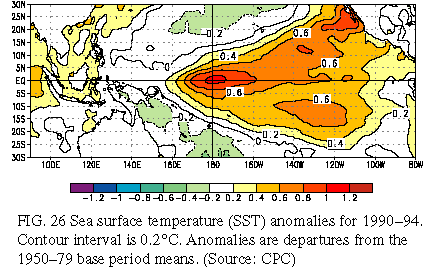
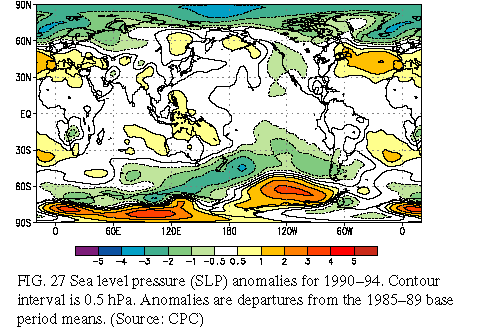
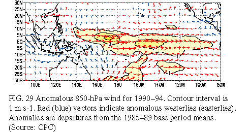
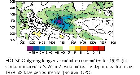
The period 1990-94 featured persistent positive sea surface temperature (SST) anomalies in the central equatorial Pacific (Fig. 26 ) and was the warmest 5-year period on record for the tropical Pacific as a whole. Consistent with this pattern of anomalous SST, sea level pressure (SLP) was below normal over the east-central tropical Pacific and above normal over the eastern Indian Ocean, Indonesia, and northern Australia (Fig. 27). This anomalous pressure pattern reflected a prolonged negative phase of the Southern Oscillation, as defined by the Southern Oscillation Index (SOI) (Fig. 28). Also observed during the period was a persistent pattern of weaker-than-normal low-level easterlies (westerly anomalies) throughout most of the equatorial Pacific (Fig. 29) and enhanced convection over the central equatorial Pacific (Fig. 30).
Collectively, these conditions reflected one of the most prolonged periods of warm El Niño-Southern Oscillation (ENSO) conditions of the century. By some measures, this five-year period is unprecedented (Trenberth 1995). However, according to the SOI and SST data, there is at least one other period during this century, and possibly a few others in the latter half of the 19th century, that featured similar, although somewhat shorter, prolonged warm (ENSO) episode conditions. The period 1911-15 appears to be most similar to the recent period, with 1911, 1912, and 1914 considered El Niño years.
Mature-phase warm-episode conditions occurred during late 1991 through mid-1992, during the first half of 1993, and from late 1994 through early 1995. During these periods, atmospheric convection was greatly enhanced over the central equatorial Pacific, the South Pacific Convergence Zone was displaced north and east of its normal position, the Intertropical Convergence Zone was shifted equatorward from its normal position in the Northern Hemisphere, and drought conditions affected northeast Australia and southeast Africa. Interestingly, near-normal conditions prevailed in the tropical Pacific during the Northern Hemisphere 1993/94 winter.
Also during 1990-94, above-normal SLP dominated the subtropical North and South Atlantic Oceans, and the high latitudes of the Southern Ocean in the east-Pacific sector, while below-normal pressure dominated the high latitudes of the Northern Hemisphere and the midlatitudes of the Southern Hemisphere (Fig. 27). The anomalous pressure pattern over the North Atlantic reflects a persistent positive phase of the North Atlantic Oscillation (NAO), which contributed to above-normal temperatures over Europe and western Russia during the period. The anomalous SLP pattern to the west and southwest of South America, reflects a greater-than-normal frequency of blocking episodes.
Mature ENSO conditions redeveloped during late 1994 for the third time in five years. This frequency of occurrence is unprecedented in the last 50 years and is comparable to that observed during the prolonged 1911-15 ENSO episode.
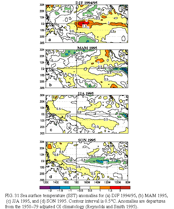
The 1994-95 warm episode showed signs of development as early as March-May 1994, when the equatorial low-level easterlies again became weaker than normal across the Pacific and the SOI decreased to -1.5 (Fig. 28). During May, positive SST anomalies reappeared along the equator near the date line, and the equatorial easterlies weakened further. These conditions continued to intensify during June-August 1994, as positive SST anomalies spread eastward across the central equatorial Pacific and were greater than +1.0°C along the equator between 170°E and 160°W.
During September-November, the positive SST anomalies continued to strengthen, and averaged greater than +2.0°C between the date line and 160°W. This increase was accompanied by a further weakening of the low-level equatorial easterlies over the central equatorial Pacific, particularly during late September and most of October. At times, the 850-hPa winds were nearly calm or even westerly during this period, especially over the central Pacific near the date line.
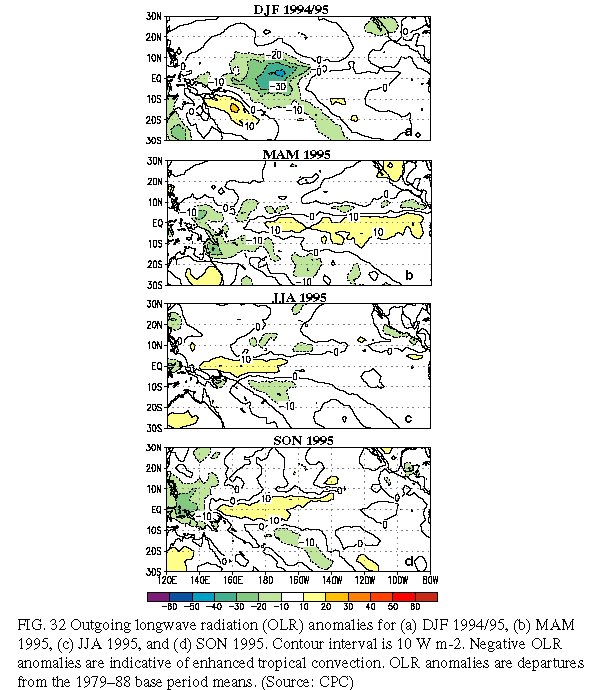
This evolution culminated in the onset of mature warm-episode conditions during December 1994-January 1995. At that time SST anomalies reached +2°C in portions of the central equatorial Pacific (Fig. 31a ) and convection was greatly enhanced in the vicinity of the anomalously warm water (Fig. 32a). Anomalous anticyclonic circulation centers developed in the upper troposphere to the north and to the south of the enhanced convection, and the midlatitude westerlies were enhanced over the North and South Pacific. This enhancement and eastward extension of the North Pacific jet stream during the period was associated with a series of intense extratropical storms that developed over the central North Pacific and then proceeded to strike the southwest coast of the United States, resulting in abnormally heavy precipitation over large portions of California and the Southwest (see Section 4a).
The low-level equatorial easterlies returned to near-normal intensity during January and remained near normal through May. Enhanced easterlies then developed over the western equatorial Pacific in June and subsequently persisted through the end of the year. By November, these enhanced easterlies had also spread eastward, covering the central and east-central equatorial Pacific. Thus, for the first time since the 1988-89 cold episode, stronger than normal easterlies dominated the entire equatorial Pacific.
Accompanying this evolution in the low-level wind field, the positive SST anomalies across the eastern equatorial Pacific steadily decreased after January 1995 (Fig. 31). By March-May 1995 (Fig. 31b), below-normal SSTs had developed from 120°W to the South American coast, and the maximum positive anomalies in the central Pacific had weakened considerably. Coincident with these changes, atmospheric convection returned to normal over the central equatorial Pacific, indicating the end of the 1994-95 period of mature ENSO conditions (Fig. 32b).
During JJA 1995 below-normal SSTs were observed from 160°W eastward to the South American coast (Fig. 31c). By September-November, the area of below-normal SSTs spread westward to 160°E (Fig. 31d), and expanded off of the equator. Additionally, the negative anomalies over the east-central equatorial Pacific intensified during the season and reached 1.0°C in many areas. At the same time, SST anomalies increased in the far western Pacific with SSTs more than 0.5°C above normal evident between 120°E and 150°E. Associated with this reversal in the pattern of SST anomalies from the previous DJF season, the pattern of anomalous tropical convection also reversed by September-November 1995, with suppressed convective activity near the date line and enhanced convection over Indonesia (Fig. 32d).
Collectively, these conditions indicated the development of a Pacific cold episode and reflected a dramatic change in the atmospheric and oceanic conditions from those which had dominated the Pacific sector since late 1990. Associated with the development of cold-episode conditions, observed global anomalies during 1995 included 1) drier-than-normal conditions over southern Brazil, northeastern Argentina, and Uruguay (see section 4c), 2) wetter-than-normal conditions over southeastern Africa (see section 4e), 3) enhanced hurricane activity in the tropical Atlantic (see section 4a ), and 4) a stronger-than-normal Indian monsoon (see section 4b).