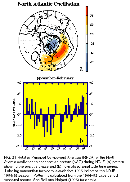
There are several prominent, recurring modes of low-frequency variability over the extratropical North Atlantic and Europe. Perhaps the most well known of these patterns is the North Atlantic oscillation. The NAO exhibits little variation in its climatological mean structure from month to month and consists of a north-south dipole of anomalies of opposite sign, with one center located over Greenland and the other spanning the central latitudes of the North Atlantic between 35° and 40°N. The positive phase of the NAO reflects below-normal heights and pressure across the high latitudes of the North Atlantic and above-normal heights and pressure over the central North Atlantic, the eastern United States, and western Europe (Fig. 31a). The negative phase reflects an opposite pattern of height and pressure anomalies. Both phases of the NAO are associated with basin-wide changes in the intensity and location of the North Atlantic jet stream and storm track, and in large-scale modulations of the normal patterns of zonal and meridional heat and moisture transport (Hurrell 1995), which in turn result in changes in temperature and precipitation patterns often extending from eastern North America to western and central Europe (Walker and Bliss 1932; van Loon and Rogers 1978; Rogers and van Loon 1979).
Strong positive phases of the NAO are often associated with above-normal temperatures in the eastern United States and across northern Europe and below-normal temperatures in Greenland and across southern Europe and the Middle East (Walker and Bliss 1932; Wallace and Gutzler 1981; van Loon and Rogers 1978). The positive NAO phase is also associated with above-normal precipitation over northern Europe and Scandinavia and below-normal precipitation over southern and central Europe. Opposite patterns of temperature and precipitation anomalies are typically observed during strong negative phases of the NAO. During prolonged periods dominated by one phase of the NAO, abnormal height and temperature patterns are also often seen extending well into central Russia and north-central Siberia.
The wintertime NAO exhibits significant interannual and interdecadal variability (Fig. 31b; Hurrell 1995). For example, the negative phase of the NAO dominated the circulation from the mid-1950s through the 1978/79 winter. An abrupt transition to recurring positive phases of the NAO then occurred during the 1979/80 winter, with the atmosphere remaining in this mode through the 1994/95 winter season. During this 15-yr interval, a substantial negative phase of the pattern appeared only twice, in the winters of 1984/85 and 1985/86.
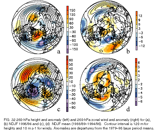
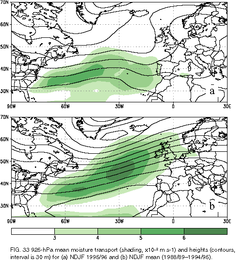
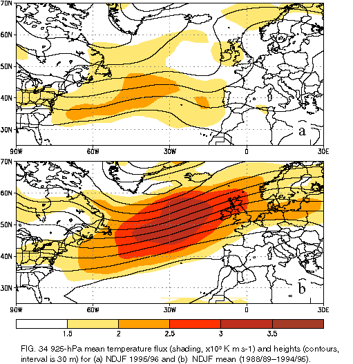
November 1995-February 1996 (NDJF 1995/96) was characterized by a return to a strong negative phase of the NAO. During this period, the circulation was marked by above-normal heights and substantial blocking activity across the high latitudes of the North Atlantic, and by below-normal heights over the eastern United States, the central latitudes of the North Atlantic, central Europe, and southwestern Russia (Fig. 32a). This pattern was associated with a westward retraction of the jet core toward the west ern North Atlantic (Fig. 32b ) and with a strong split in the flow over the central and eastern North Atlantic. This "split" is identified by a strong low-latitude flow extending from the southeastern United States to northern Africa. a poleward shift of the northern branch of westerlies to central Greenland and northern Scandinavia, and a marked reduction in the normal northwesterly flow across northern Europe (Fig. 32a). During NDJF 1995/96, significant low-level (925 hPa) moisture transport (Fig. 33a) and heat flux (Fig. 34a) was confined to latitudes south of 45oN in the southern branch of westerlies, with the axis of largest transport extending from the southwestern North Atlantic eastward to Portugal and extreme northwestern Africa. Farther north, there was abnormally low moisture transport and heat flux across northern Europe and southern Scandinavia during the period.
This stands in strong contrast to the period from NDJF 1988/89 through NDJF 1994/95 (Figs. 32c,d), which was characterized by a prolonged positive phase of the NAO. During this 7-yr period the mean upper-level height field was dominated by below-normal heights throughout the high latitudes of the North Atlantic and by above-normal heights extending across the central latitudes of the North Atlantic from eastern North America to Europe (Fig. 32c). This anomaly pattern reflected an eastward shift toward the Labrador Sea of the mean Hudson Bay trough and a flattening of the mean ridge over the high latitudes of the central North Atlantic. It also reflected a notable absence of blocking activity across the high latitudes of the North Atlantic. Accompanying these conditions was an enhanced North Atlantic jet stream, with a single jet core extending northeastward from the eastern United States to northern Europe and southern Scandinavia (Fig. 32d). During this period, significant poleward moisture transport (Fig. 33b) and heat flux (Fig. 34b) was evident, with the axis of maximum transport extending from the southwestern North Atlantic to Great Britain. The maximum values of heat transport over the North Atlantic averaged nearly double those observed during NDJF 1995/96. Farther south, transports were substantially reduced across the southeastern North Atlantic and southern Europe when compared to NDJF 1995/96.
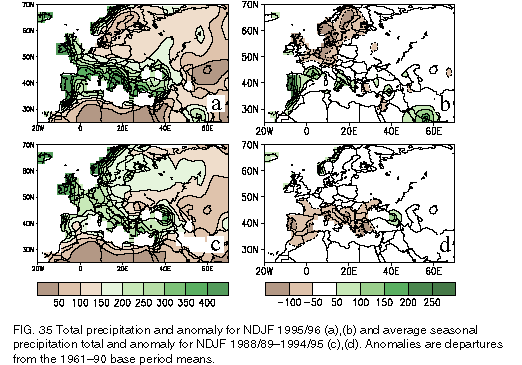
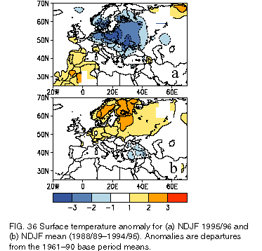
These contrasting conditions contributed to substantial differences in the large-scale precipitation and surface temperature patterns across eastern North America, Europe, and western Russia between the two periods. Overall, northern Europe and Scandinavia were abnormally dry and cold during NDJF 1995/96 and abnormally wet and warm during NDJF 1988/89-1994/95 (Figs. 35, 36). In contrast, southern Europe and northwestern Africa were abnormally wet and warm during NDJF 1995/96 and abnormally dry during NDJF 1988/89-1994/95. These anomalous temperature and precipitation patterns are typical of the opposite phases of the NAO (van Loon and Rogers 1978).
Over North America, the anomalous height and wind patterns during NDJF 1995/96 reflected an intensification and southward extension of the climatological mean Hudson Bay trough, resulting in enhanced northwesterly geostrophic flow and an increased number of cold-air outbreaks into the northeastern and north-central United States and large parts of central Canada. Overall, below-normal surface temperatures were observed throughout the northeastern and north-central United States and large portions of central Canada during the period [see section 4b(3)].