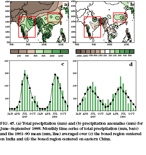
The Indian summer monsoon typically lasts from June through September, with large areas of western and central India receiving more than 90% of their total annual rainfall during the period, and southern and northwestern India receiving 50%-75% of their total annual rainfall. Overall, area-averaged monthly rainfall totals range from 200-300 mm, with the largest values observed during the July-August peak in the monsoon season (Fig. 45c).
Overall, area-averaged rainfall was near-normal across India during June and July 1998, and above-normal during both August and September (Fig. 45c). Abundant rains then continued through October, when area-averaged totals reached 130 mm and exceeded the long-term average by 30%.
Regionally, the 1998 season featured abundant rains (1200-1600 mm) in the typically heavy rainfall area of western India (Fig. 45a ), which is 200-600 mm above the long-term mean (Fig. 45b). Elsewhere, seasonal rainfall was near normal over most of India, with above-normal totals confined to western Nepal and adjacent India and below-normal totals observed in the extremely heavy rainfall areas of Burma and Bangladesh.
The 1998 monsoon season also featured several episodes of catastrophic human loss. Locally heavy rains and flooding killed more than 2800 people in India and Bangladesh and another 250 people in Nepal. Farther west, a major Arabian Sea cyclone hit Gujarat, India on 9 June, claiming 1,126 lives. In Pakistan and northwestern India very hot temperatures typically precede the monsoon rains. From mid-May through early June 1998, this heat was extreme with temperatures occasionally exceeding 50°C (122°F). This heat wave claimed an estimated 2,500 lives.
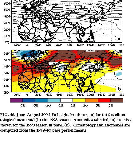
The upper-level monsoon ridge typically extends from northeastern Africa to southeastern Asia (Fig. 46a) and exhibits considerable interannual variability in its strength and zonal extent. During JJA 1998 the ridge was stronger-than-average across northern Africa, the Indian subcontinent, and southeastern Asia (Fig. 46b). This enhanced ridge was associated with a persistent pattern of above-normal heights across the subtropical North Atlantic and most of Eurasia, suggesting a link to the larger-scale circulation features and not to the localized regions of enhanced rainfall over India. In the region downstream of the amplified ridge enhanced cyclonic flow during June and July contributed to excessive rainfall and catastrophic flooding in the Yangtze River basin of central China [see section 4b(2)].
In contrast, the 1997 monsoon season featured a suppressed monsoon ridge from northern Africa eastward to southeastern Asia, despite a pattern of rainfall anomalies over India (Bell and Halpert 1998, see their Figs. 49 and 52) that was similar to that observed in 1998. Accompanying this suppressed ridge was a pronounced southward shift in the extratropical westerly winds along its northern flank, with westerly disturbances impacting northern India and southeastern Asia during much of June-July 1997. These conditions led to severe flooding in southern China and southeastern Asia, which contrasts with the flooding in central China observed during 1998.
2) Yangtze river flooding: July-August 1998
The Yangtze river extends from the Tibetan Plateau to eastern China and is the third longest river in the world. During 1998, record flooding of the Yangtze River and adjacent river valleys ultimately affected more than one-fifth of the entire population of that country and was associated with more than 3600 deaths. The flooding destroyed approximately 7.3 million houses and damaged another 13.8 million. It also destroyed 45,000 schools, which directly affected 8.5 million school children. The estimated total damage from the flooding was US $32 billion.
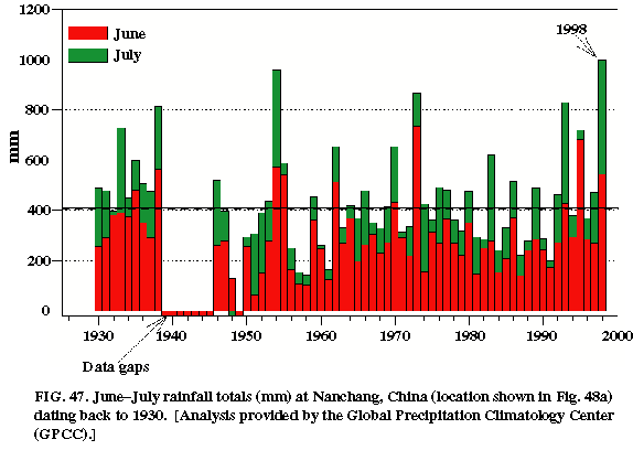
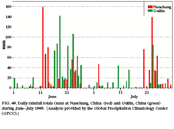
The catchment basin of the Yangtze river, approximated by the boxed region in Fig. 45a, experiences a well-defined rainy season, with the largest totals typically observed during the April-August warm season and the smallest totals observed during the November-March cool season (Fig. 45d ). Area-averaged rainfall totals are largest during May-July, with a peak of 200 mm normally observed in June. There is also considerable interdecadal and interannual variability in summertime rainfall across the Yangtze River basin (Fig. 47). For the period 1930-present, particularly wet periods [illustrated by a time series of June-July rainfall totals at Nanchang, which is located in the northeastern part of the Yangtze River basin (Fig. 48a)] have included 1930-40, 1962-80 and 1992-98, while dry periods have included 1955-62 and 1980_-0.
During June-September 1998 area-averaged precipitation totals were significantly above-normal in the Yangtze River basin (Fig. 45d ). The most excessive rainfall occurred during June and July, when area-averaged totals exceeded 300 mm and 220 mm, respectively. Overall, the largest anomalies were observed over the eastern portion of the basin in the region which includes Nanchang (Fig. 45b ). At this location, record June-July 1998 rainfall totals of 1000 mm surpassed the previous record of approximately 950 mm set in 1954 (Fig. 47).
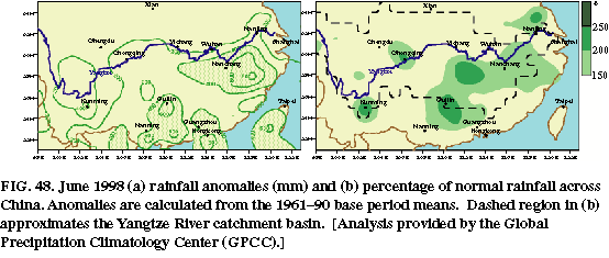
In June more than 200 mm of rain was observed throughout the southern half of the Yangtze River basin (Fig. 48a), with totals exceeding 400 mm (150%_200 % of normal, Fig. 48b ) in the vicinity of Nanchang, in the south-central region near Guilin and in the southwest near Kumming. Much of this excessive rainfall occurred between 12-26 June, when Nanchang and Guilin recorded 510 mm and 650 mm, respectively (Fig. 49). These stations recorded more than 25 mm of rain on six and eight days, respectively, during this 15-day period, and each recorded more than 50 mm of rain on five days. These excessive rains followed a prolonged period of above-normal precipitation and snowfall during the 1997-98 cool season, which increased the flood potential by producing higher than normal river levels prior to the onset of the rainy season. These conditions then contributed to the onset of the first major flooding of the Yangtze River beginning in early July.
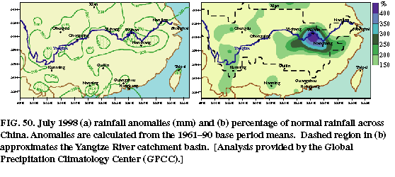
During July an additional 200-400 mm of rain was observed throughout the southern half of the basin (Fig. 50a), with the largest totals again observed in the eastern, south-central, and southwestern sections. Monthly rainfall totals averaged more than 150% of normal in the east, with many locations recording totals of 200-300 % of normal (Fig. 50b ). The largest totals exceeded 600 mm in the region northwest of Nanchang, which is more than 400% of the normal July total. Much of the excessive rainfall at Nanchang occurred during 20-25 July when more than 345 mm were recorded (Fig. 49). During this 6-day period, totals exceeded 25 mm on five days and exceeded 60 mm on three days. This excessive rainfall contributed to additional flooding at the end of the month.
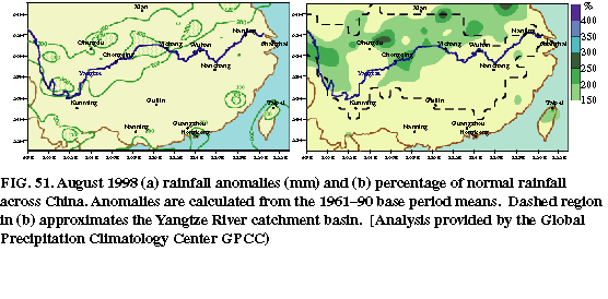
During August, rainfall returned to near normal in the region south of the Yangtze River (Fig. 51a), but averaged 200-300 mm (150-200% of normal) along and north of the river (Fig. 51b ). Despite these lower totals, the continuation of normal and above-normal rainfall over such a large portion of the Yangtze River basin further exacerbated flooding conditions.
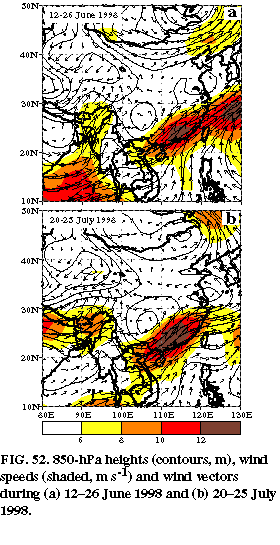
Much of the summertime rainfall across the Yangtze River basin and southern China is convective in nature and is sometimes triggered by midlatitude disturbances embedded in the westerly flow in the region north of the Asian monsoon ridge. The interannual variability of this westerly flow and therefore the interannual variability of rainfall in the Yangtze River basin, can be influenced by both the amplitude and northward/ eastward extent of the monsoon ridge. For example, Bell and Halpert (1998) noted that excessive rainfall across southern China during 1997 was linked to a series of powerful extratropical disturbances moving well south of their normal position in response to a poorly-developed and much weaker-than-average strength of the upper level monsoon ridge. During 1998 the excessive rainfall during both 12-26 June and 20-25 July was linked to the persistence of a strong low-level cyclonic circulation centered over the heart of the Yangtze River basin (near 110°E, 30°N) and to its attendant warm frontal boundary and very strong wind shift line which extended eastward along an axis nearly coincident with the eastern half of the river basin (Figs. 52a, b). During both periods these features were linked to extratropical low-pressure areas and were strengthened at times by powerful upper-level midlatitude disturbances propagating eastward along the northern flank of an amplified monsoon ridge (see Fig. 46b).