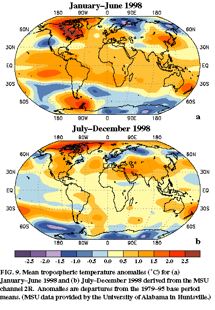
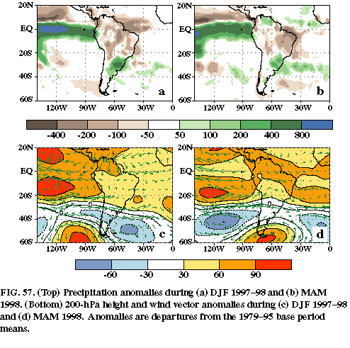
During the first half of 1998 the strong Pacific warm episode greatly impacted temperature (Fig. 9a) and precipitation (Figs. 57a, b) patterns over South America. Typical El Nińo-related impacts (see, e.g., Ropelewski and Halpert 1987, 1989; Aceituno 1988; Halpert and Ropelewski 1992; Kousky and Kayano 1994) at various times of the year over South America include: 1) drier than normal conditions over northern South America, the Amazon basin, and northeastern Brazil, 2) wetter than normal conditions over southern Brazil, Uruguay, northeastern Argentina, and over coastal Ecuador and northern Peru, and 3) above normal temperatures over eastern Brazil. All of these features were evident during the 1997-98 El Nińo.
During December 1997-May 1998 drier than normal conditions extended across most of northern South America, except for western sections of Ecuador and northern Peru. Rainfall deficits of more than 300 mm were observed during DJF (Fig. 57a ) in the central and western Amazon Basin, and more than 400 mm during MAM over portions of northeastern Brazil (Fig. 57b). This dryness contributed to unprecedented wildfire activity in the northern Amazon Basin during January-March, and in southwestern Brazil and Bolivia later in the year.
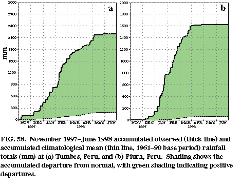
In contrast, excessive rainfall (up to 10 times normal) covered western Peru and Ecuador from November 1997 through May 1998, leading to severe flooding and mudslides in both countries which killed 450 people and caused more than US $3 billion in damage. In coastal Peru, where very little rainfall normally occurs, totals during the period reached 1500 to 2200 mm (Fig. 58). In extreme northwestern Peru, the city of Tumbes (Fig. 58a) experienced much of this rain during January-April, when totals reached 1750 mm. Overall, more than 300 mm of precipitation was measured in each of these months at this location, with the largest totals (700 mm) observed in February. Farther south in Piura, Peru (Fig. 58b ), the excessive rainfall (approximately 1450 mm) was observed during January-March, with the largest totals (650 mm) recorded in January.
Above-normal rainfall was also observed during December 1997-May 1998 over southern Brazil, Paraguay, Uruguay, and northeastern Argentina (Figs. 57 a, b), with many areas recording surpluses exceeding 200 mm in each season. In April alone rainfall in southern Paraguay and northeastern Argentina reached 400 mm (200%-400% of normal). Overall, the excessive rains led to major flooding in each of these countries.
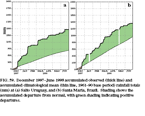
The excessive rainfall in Uruguay and southern Brazil during December 1997_May 1998 is highlighted by time series for two individual stations (Fig. 59). At Salto, Uruguay (Fig. 59a) 1450 mm of rain was recorded between mid-December 1997 and mid-April 1998 (normal is 450 mm), with 900 mm of rain observed during the 41-day period 20 December 1997-31 January 1998. Precipitation after this period was episodic, falling mainly during two extreme rain events that occurred in early March and mid-April. In extreme southern Brazil, Santa Maria experienced the onset of heavy rains in mid-December, and a continuation of excessive precipitation through May (Fig. 59b). Totals during the period reached 1300 mm (normal accumulation is 1000 mm), with the bulk of the rain occurring during three distinct periods: late December (375 mm), late January-early February (175 mm), and the first half of March (350 mm).
This above-normal rainfall was associated with persistent upper-level circulation features over the subtropics and extratropics. Prominent aspects of this circulation (Figs. 57c, d) included 1) positive upper-level height anomalies throughout the Tropics and subtropics, 2) negative height anomalies in the midlatitudes, 3) an enhanced thermal contrast, with positive temperature anomalies to the north of 25°S and negative anomalies over portions of central and northern Argentina (Fig. 9a), and 4) an enhanced jet stream and increased storminess in the subtropics along the poleward flank of the enhanced subtropical ridge. Similar circulation features also contributed to enhanced rainfall in these regions during June-November 1997 (Bell and Halpert 1998, see their Figs. 27c, d, and 29b).
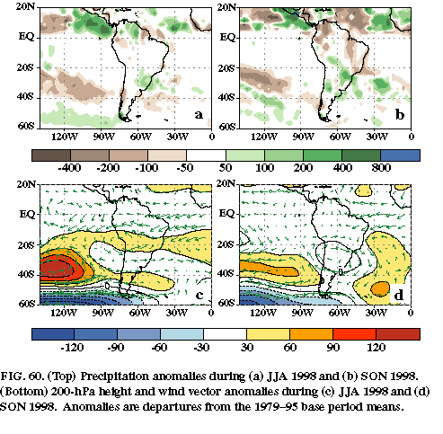
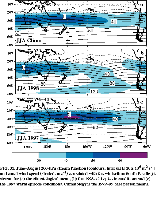
As the rapid transition from El Nińo to La Nińa conditions occurred in the equatorial Pacific during May-June (see section 3a ), upper-level circulation features over the South Pacific also evolved rapidly from those typical of warm episodes to those commonly found during cold episodes. For example, the negative height anomalies and anomalous cyclonic circulation observed near 40°S across the eastern South Pacific during the first half of 1998 were replaced by above-normal heights and an anomalous anticyclonic circulation during JJA and SON (Figs. 60c, d). Also, the anomalous anticyclonic circulation in the subtropics was replaced by a cyclonic circulation anomaly. Accompanying these changes the jet stream shifted to well south of its normal position and completely disappeared from the 20°-40°S band (see Fig. 31b). This pattern contributed to drier-than-normal conditions between 20°-40°S across the eastern South Pacific (Figs. 60a, b) extending into central Chile and portions of southern Argentina, and to enhanced rainfall at higher latitudes of the South Pacific between 40°-60°S.