|
Latest Monthly Assessment -
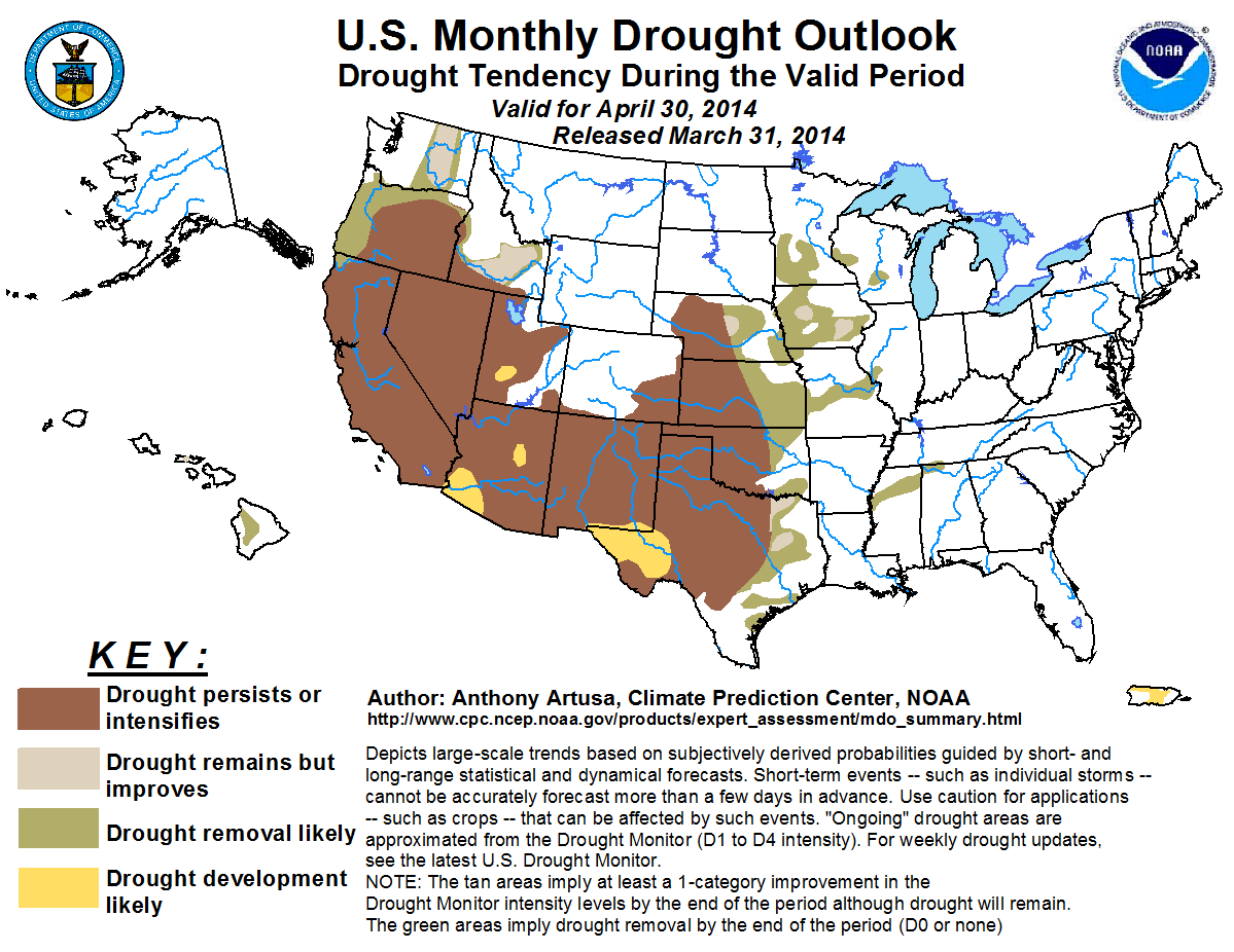
In the past two weeks, heavy precipitation (2 inches or more) fell over the coastal ranges, Cascades, northern Sierras, and Bitterroots of the mountainous West, much of
the Central and Eastern Gulf Coast region, and from the Nation’s Capital northeastward across southern and eastern New England. The Southwest, southern Rockies, and most of the
central and southern Plains received a half-inch or less of precipitation during this same time period. California and the Pacific Northwest are expected to receive periods of
precipitation during the next two weeks, but it is unlikely to be enough to change the current drought depiction over California and interior Oregon, where drought
persistence/intensification is forecast. Improvement and/or drought removal is anticipated over coastal Oregon, east-central Washington, and southeastern Idaho. The Great
Basin, Southwest, and the central and southern High Plains are not predicted to receive enough precipitation to warrant a one-category improvement during April. Precipitation
anticipated during the first week of April, and an increasingly wet climatology favor improvement and/or drought removal across the lower Great Plains. Precipitation forecasts
at various time-scales out to one month in advance and climatology support Improvement and/or Removal across the Upper (and especially Middle) Mississippi Valley. Improvement
and/or removal of drought is also anticipated across the Hawaiian Islands, while drought development is expected across much of Puerto Rico.
|
|
Tools used in the monthly U.S. Drought Outlook (MDO) included the official CPC temperature and precipitation outlook
for April 2014, various short- and medium-range forecasts and models such as the 6-10 day and 8-14 day forecasts, the NAEFS and ESRL precipitation
outlooks, the soil moisture tools based on the Constructed Analog on Soil (CAS)
moisture, dynamical models (CFSv2, NMME, and IMME), the 384-hour total precipitation forecasts from several runs of the
GFS, the 7-day quantitative precipitation forecast from the NCEP Weather Prediction Center (WPC), climatology, and
initial conditions. The phase of ENSO is expected to remain neutral during the period.
Persistent upper-level ridging across western North America continued to promote drought conditions across California, the Great Basin, the Desert Southwest, and the
southern Rockies. Percent of Normal Precipitation (PNP) values (past 14-days) are in the lowest 10 percent over much of southern California, western and southern
Nevada, eastern Utah, Arizona, and extreme western portions of both Colorado and New Mexico. As a whole, the state of California received only about 25-50 percent of
the precipitation that it typical gets during the Water-Year so far (which started on October 1, 2013). In the hardest hit region of south-central California, 10 to
20 inches of precipitation are needed to bring the Long-term Palmer Drought Severity Index (PDI) back up to -0.5 or higher, which is one way of determining the end of
a drought. Climatologically, southern California, the southern Great Basin, Desert Southwest, and the southern Rockies are also experiencing the tail end of their
winter wet season. Periods of precipitation are forecast across the northern half of California, and the coastal portions of southern California during the first week
of April, and during the Week 2 period. The official updated 30-day precipitation outlook calls for elevated odds of below-median rainfall across southeastern
California, and much of Nevada, Utah, and Arizona.
Forecast confidence for California, Great Basin, Desert Southwest, and the southern Rockies is moderate to high.
The Pacific Northwest has seen a succession of cyclonic storm systems in recent weeks, in the wake of relatively warm and dry conditions which prevailed during the
early winter in association with the persistent West Coast ridge. PNP values ranged from 25-50 percent over the past 2 weeks over interior Oregon and southeastern
Idaho to 150-200 percent over the northern Cascades in Washington. Mountain snowpack (latest available, as of March 1, 2014) ranged between 70-110 percent of median
(Washington, southeastern Idaho, and the northern interior of Oregon), and only within the lowest 25 percent in the southern interior of Oregon. Mountain snowpack
conditions will be reassessed within the first few days of April. Precipitation at various time-scales out to one month in advance, and a still favorable (though
declining) precipitation climatology favor opportunities for at least a 1-category improvement across much of this region (which in some cases equates with drought
removal, with the possible exception of interior Oregon).
Forecast confidence for the Pacific Northwest is moderate.
Long-term dryness and drought continues across the central and southern Plains, in particular the High Plains. PNP values range between 5-25 percent of normal across
western and central Kansas, western Oklahoma, the Texas Panhandle, and from central Texas westward to the Big Bend region. According to the PDI, 3-6 inches are needed
over the next 4 weeks (assuming the region receives normal precipitation in that 4-week period) to end the drought in western Oklahoma and the Texas Panhandle. Though
0.5-1.0 inch of rain is forecast during the first week in April, it is unlikely to be enough to warrant a one-category improvement in the U.S. Drought Monitor. The
updated 30-day precipitation outlook shows no significant tilt in the odds towards any one category, so EC is assigned. It is thought that the lower Plains, being
more susceptible to the influx of low-level Gulf moisture and frontal boundaries, has the best odds for drought Improvement and/or Removal. However, drought
Persistence and/or Intensification appears more likely for the central and southern High Plains.
Forecast confidence for the central and southern Plains is low to moderate.
The Upper and Middle Mississippi Valley: Temperatures during the past 30-days have averaged between 5-9 degrees F below-normal in this region. In the Upper
Mississippi Valley, soils are still frozen down to several feet. Like last April, frozen soils will be slow to thaw, especially given the below-normal temperatures
favored in this region for the upcoming two-week period. According to the Weekly Weather and Crop Bulletin issued March 25, 2014, snow depths are generally 8 inches
or less over most of the drought areas indicated on this latest Monthly Drought Outlook. In much of Iowa, where the driest conditions in the Midwest are located, the
PDI shows 3-6 inches of precipitation is needed to bring conditions back to normal. The Week 2 and updated 30-day precipitation outlooks anticipate enhanced odds of
below-normal temperatures and above-median precipitation for most of the upper and middle Mississippi Valley. Climatologically, these areas experience a ramping up of
precipitation in the AMJ season, receiving between 30-40 percent of their annual total. Improvement and/or Removal of drought throughout this region is based on 1-7
day, 8-14 day and updated 30-day precipitation outlooks and climatology.
Forecast confidence for the upper and middle Mississippi Valley is low to moderate.
Periods of enhanced rainfall during the winter rainy season have promoted drought reduction across the Hawaiian Islands. The anticipation of April showers forms the
basis for the removal of drought across the Big Island, with at least a 1-category improvement expected for Molokai.
Forecast confidence for Hawaii is moderate.
Puerto Rico: Very dry conditions and low reservoirs favor the Development of drought over central and northwestern portions of Puerto Rico, with April being a
climatologically dry time of year. However, it is expected to be short-lived, as May is typically one of the wettest months of the year, in addition to October.
Forecast confidence for Puerto Rico is moderate.
|


