|
Latest Monthly Assessment -
During the past 14 days (since the SDO release on Oct. 16), above-normal precipitation in the lower 48 States was limited to the
Northwest, New England, upper Great Lakes, and upper Rio Grande Valley. The remainder of the Nation observed subnormal
precipitation and above normal temperatures, with only parts of the Southeast experiencing slightly below normal readings.
Moderate to heavy rains fell on most of Hawaii from Tropical Storm Ana which passed to the west of the islands. Western Puerto
Rico measured surplus rains, but eastern sections recorded subnormal amounts. ENSO neutral conditions remained in the
equatorial Pacific Ocean, but an El Niño watch continued as El Niño is favored to begin in the next 1 to 2 months and last
into the Northern Hemisphere spring 2015.
Precipitation normally peaks in the Pacific Northwest during the late fall and winter months, while California's main wet
season usually occurs from the late fall into the early spring, with December-February most critical for receiving the bulk of
their annual precipitation. In contrast, the Southwest, Plains, and Southeast are typically dry during November, but with
lower temperatures and little to no evapotranspiration, this time of the year is ideal for soil moisture recharge before the
ground freezes in the north. During early November, a storm system laden with tropical Pacific moisture should drop ample
rains on most of the south-central Plains before tracking into the Ohio Valley and Northeast, while yet another system brings
precipitation to the Pacific Northwest and northern Rockies. Meanwhile, a possible Nor'easter will remain just off the Atlantic
Coast, although it may brush coastal New England with rain. This precipitation in the Northwest, south-central Plains, and New
England should be enough for some improvement, with the western edge of improvement in Texas and Oklahoma highly dependent on
storm totals and November normals (that rapidly decrease from east to west). By mid-month, the odds favor above-median
precipitation across the northern third of the U.S. and in Florida, with subnormal precipitation in California and the
Southwest. Temperatures are likely to be above-normal in the western and northern U.S. Although the updated November
precipitation outlook favors above-median amounts in Arizona, New Mexico, and western Texas, November normal are quite low and
much of the remaining drought is long-term (hydrological)- requiring large amounts of precipitation - which is not likely
during November, hence persistence was shown. In California and the Great Basin, persistence is expected with the normal wet
season still about a month away, and dry and warm conditions forecast during the first half of November. In the Southeast, the
forecasts over various time frames showed uncertainty as to possible wetness (improvement) or dryness (development), hence
persistence was depicted.
In Hawaii, widespread moderate to heavy rains from Tropical Storm Ana provided some drought relief, but expected drier
conditions and the onset of the normal dry season should keep existing D1 areas as is. In Puerto Rico, the late summer and
fall months are typically wet, and although October was dry in eastern sections, November outlooks tilt toward near-normal
rainfall, not enough to erase D1 but enough to prevent deterioration, hence status-quo conditions.
|
|
Tools used in the U.S. Monthly Drought Outlook (MDO) included the official Climate Prediction Center (CPC) updated temperature
and precipitation outlooks for November 2014, various short- and medium-range forecasts and models such as the 5-day and 7-day
precipitation totals from the Weather Prediction Center, the 6-10 day and 8-14 day CPC forecasts, the NAEFS precipitation
outlooks, the soil moisture tools based on the Constructed Analog on Soil (CAS) moisture, dynamical models (CFSv2, NMME, IMME,
and IRI), the 384-hour total precipitation forecasts from several runs of the GFS, climatology, the latest official Drought
Monitor analysis, observed precipitation during the last few weeks, and initial conditions.
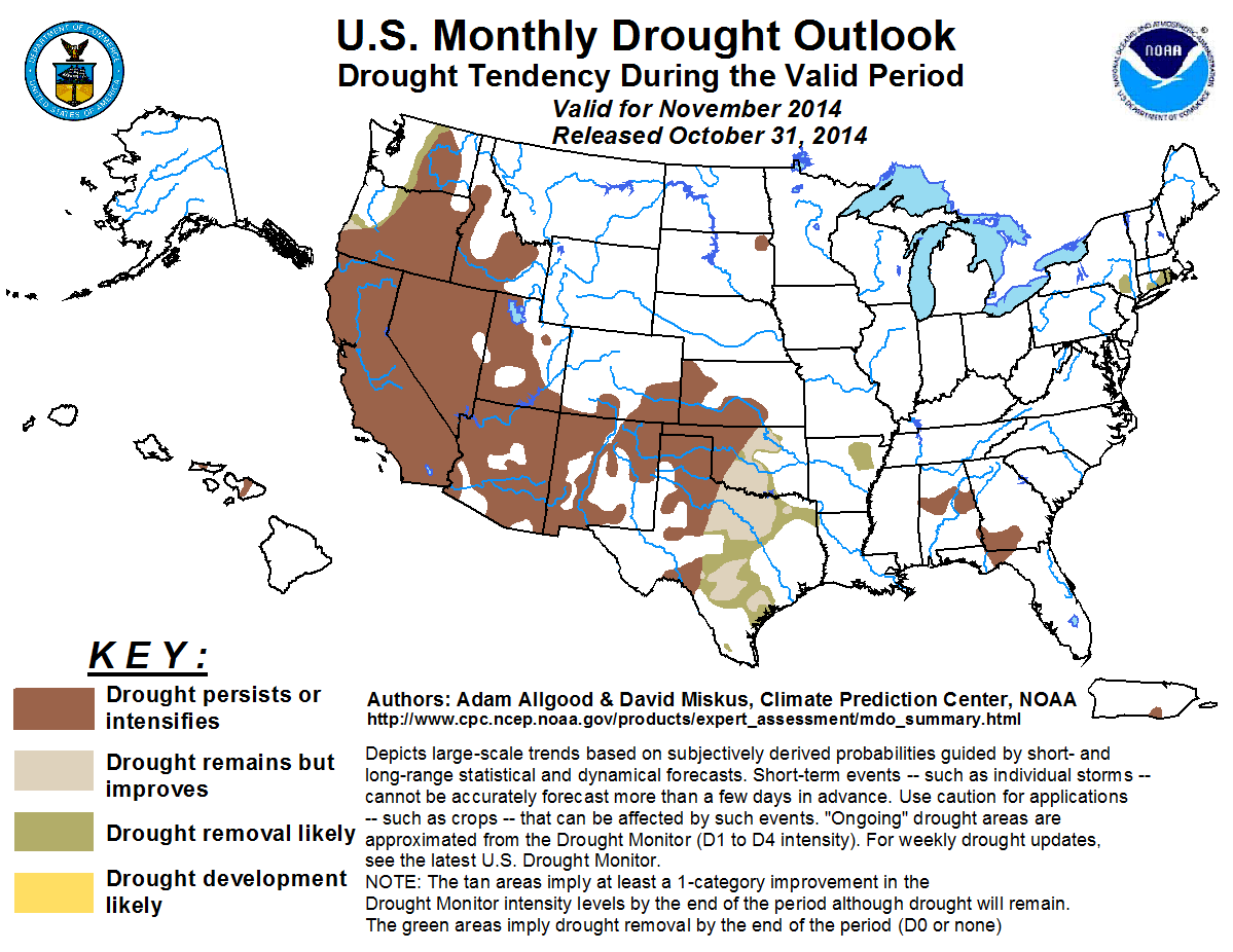
A late October Nor'easter brought widespread soaking rainfall (0.5 to over 4 inches) to New England, boosting moisture across
Massachusetts, Vermont, New Hampshire, and Maine. Smaller accumulations were observed across southern New England, where
moderate drought (D1) conditions persist across parts of southern New York, southeastern Connecticut, and Rhode Island.
Significantly reduced evapotranspiration due to the end of the growing season and cooler temperatures makes November an ideal
month for soil moisture recharge across the Northeastern States before the ground freezes during the winter. Therefore, any
precipitation that falls during the month has the potential to efficiently reduce lingering drought conditions. During the
upcoming week, an area of low pressure is forecast to deepen rapidly off of the mid-Atlantic coast and lift northward.
Although the majority of the rainfall is anticipated to remain offshore, the WPC 7-day outlook indicates accumulations of
0.5 inches or more across coastal New England, with lighter amounts further inland. Both the CPC 6-10 and 8-14 day outlooks
tilt the odds towards above median precipitation across the northeastern U.S., while the revised November monthly outlook
maintains equal chances for near, above, and below median precipitation. Based on recent rainfall and an anticipated wet
signal during the first half of November, drought removal is forecast for the D1 areas of southern New England and New York.
Forecast confidence for the Northeast is moderate.
Below normal rainfall across the southeastern Atlantic coastal Plain and adjacent Piedmont resulted in an expansion of
abnormal dryness (D0) across parts of the Florida Panhandle, Georgia, and the Carolinas during the past week. D0 conditions
also expanded westward across parts of Mississippi, while moderate to severe drought conditions persisted across central
Alabama, southwestern Georgia, and northern Florida. November is a relatively dry time of year across the Southeast,
particularly along the Atlantic coastal Plain, dry weather during this period typically aids fieldwork activities, while
cooler temperatures reduce the evapotranspiration rates. Therefore, drought expansion tends to slow during November, while
periods of rainfall can be effective in ameliorating existing drought conditions. Scattered showers fell across Alabama,
Georgia, and the coastal Carolinas late in the week. The WPC 7-day precipitation outlook forecasts light precipitation across
the Southeast, while the CPC 6-10 day outlook tilts the odds towards above median rainfall. The revised November monthly
outlook tilts the odds towards above median precipitation for the central Gulf Coast primarily west of the drought areas,
while maintaining no signal for the remainder of the Southeast. Based on the seasonably dry climatology and lack of a strong
signal favoring enhanced rainfall, drought persistence is maintained across central Alabama, southern Georgia and northern
Florida.
Forecast confidence for the Southeast is moderate.
Although near average precipitation early in the month brought localized relief across parts of the central and southern
Plains, below normal rainfall and unseasonable warmth during late October promoted drought persistence and expansion across
eastern Texas and southeastern Oklahoma, where rainfall deficits exceeded 1 inch during the last week of the month. Much of
Texas and Oklahoma remain entrenched in long-term and significant drought conditions. During November, there is a tight
gradient in climatological precipitation, with dryness increasing towards the west across Kansas, Oklahoma, and Texas. The
WPC forecasts widespread, soaking rains exceeding two inches across much of the core drought regions of Texas and Oklahoma
for the upcoming week. These rains may be augmented by the remnants of Tropical Storm Vance, which is forecast to attain
hurricane intensity over the eastern Pacific before making landfall along the western coast of Mexico. The CPC 6-10 day
outlook favors enhanced rainfall across eastern Texas and Oklahoma, and the updated November monthly outlook also tilts the
odds towards above median precipitation for the southern Plains. These forecasts indicate a potential for widespread short
term drought amelioration during November; however, the potential for improvements to the more entrenched long term drought
conditions across central Texas and the extreme to exceptional drought across northern Texas and central Oklahoma, is more
uncertain. Therefore, an area of drought improvement and removal of moderate (D1) drought is indicated for the southeastern
Plains, including parts of eastern and central Texas and eastern and central Oklahoma. Drought persistence is maintained for
west-central and western Texas, as well as western Oklahoma, where climatological precipitation is low and long-drought
is more entrenched.
Forecast confidence for the central and southern Plains is moderate to high.
Below normal precipitation during the previous two months promoted the expansion of abnormal dryness (D0) across Minnesota
and the Dakotas, while a small area of moderate drought (D1) developed over northeastern South Dakota. November is a
climatologically dry time of year for the northern Plains and upper Midwest, and seasonably cold temperatures keep
evapotranspiration rates very low. Therefore, drought conditions tend to develop slowly during the Fall, while bouts of
precipitation can boost soil moisture efficiently before the winter freeze. Mostly dry weather is anticipated during the
first week of November. While the CPC 6-10 and 8-14 day outlooks tilt the odds towards above median precipitation along the
northern tier of the CONUS, the updated November outlook maintains equal chances for below, near, or above median
precipitation. Based on the cool and dry climatology and a potential for above average precipitation near the middle of the
month, no further drought expansion is anticipated for the northern Plains or upper Midwest. Drought persistence is maintained
for the D1 area in northeastern South Dakota, however, due to the low climatology.
Forecast confidence for the northern Plains and upper Midwest is moderate to high.
Climatological precipitation begins to increase across California from north to south during November, but the primary wet
season for the State begins during December. November is a climatologically dry time of year for the Great Basin and interior
Southwest as the monsoon season is over. During the past month, seasonably dry weather was observed over central and southern
California and Nevada, while late monsoon rains fell across parts of southern Arizona and New Mexico. Outside of small
improvements across western New Mexico, drought conditions remained largely unchanged across the Southwest during the past
four weeks. In contrast, widespread heavy precipitation fell across northwestern California and the southern Cascades, which
may result in some short-term improvements. During the upcoming week, a series of storms impacting the Northwest is
anticipated to bring precipitation to coastal areas of northern California and across the Cascades and northern Sierras.
Although these rains would be welcome, it is unlikely that they will be robust enough to provide significant early relief to
the entrenched, multi-year drought. Additionally, the CPC 8-14 day outlook indicates a pattern shift towards drier weather
across California. The revised monthly outlook indicates no signal for wet or dry during November. Therefore, based on
climatology, where the bulk of California's winter precipitation falls after November and the interior Southwest is dry, as
well as the significantly dry initial conditions, drought persistence is forecast for all of California and the rest of the
Southwest.
Forecast confidence for the Southwest and California is high.
Widespread heavy precipitation from multiple systems since mid-September yielded above average rainfall to coastal regions of
Oregon and Washington and boosted moisture across the Cascades ranges. The favorable pattern brought relief to abnormal
dryness and drought conditions across northwestern Oregon and northwestern Washington. In contrast, drier conditions east of
the Cascades resulted in degradation for northeastern Oregon. Climatological precipitation increases markedly during November
across the Northwest, and the early storms have resulted in a wet start to the rainy winter season. Additional heavy
precipitation is forecast during the upcoming week across coastal areas and the Cascades, with moisture anticipated to
increase across the northern Rockies of Idaho and Montana as well. Much less precipitation is forecast over eastern
Washington and Oregon, however, due to the rain shadow effects of the mountain ranges, and most of the remaining core drought
areas are in this rain shadow region. Therefore, improvement is anticipated across the drought areas of the Cascades, while
persistence is maintained further east.
Forecast confidence for the Northwest is moderate to high.
Hurricane Ana passed just south and west of the Hawaiian Islands during mid to late October, bringing abundant moisture.
Reservoir deficits remain in some locations, however, so moderate hydrological drought areas across Molokai and Maui persisted
through the end of the month. The CFS model indicates that some moisture along an active ITCZ south of Hawaii may propagate
northward and affect the islands early in the month; however, it is unlikely that sufficient rainfall will fall during
November to reduce long term drought conditions before the winter rainy season.
Forecast confidence for Hawaii is moderate.
Scattered thunderstorms fell across western Puerto Rico during the past week, but eastern sections saw subnormal October
rainfall, increasing the abnormal dryness there. November is climatologically wet across Puerto Rico, and a return to
suppressed convective conditions across the Caribbean could result in drought degradation. Both the CFS and ECMWF indicate
enhanced rainfall for Puerto Rico during early October. While the CFS trends slightly drier during mid-October, the ECMWF
maintains a wet signal during Week-2. Both models have little signal during the end of the month. Based on a lack of a dry
signal in the tools, no further drought development is anticipated, but sufficient rainfall to significantly improve drought
is likewise not anticipated.
Forecast confidence for Puerto Rico is moderate.
There is no drought indicated or anticipated to develop across Alaska during November.
|


