|
Latest Monthly Assessment -
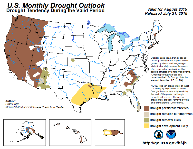
During July, limited drought improvement occurred across the Southwest, with drought intensifying over the Pacific Northwest.
Drought continues to affect parts of the Southeast, while short-term rainfall deficits increased across the western Gulf
Coast, East Texas, and the Lower Mississippi Valley. Drought doubled in coverage across Alaska during the past month, with
the state's wildfire season on a record pace. Below-average rainfall associated with the ongoing El Niño intensified drought
across Puerto Rico this summer.
The monthly drought outlook valid for August is based on initial conditions, the CPC August precipitation and temperature
outlooks, and climatology. The most likely area for drought development across the continental U.S. is the Lower Mississippi
Valley and East Texas due to a lack of rainfall during July. Also, the first half of August is expected to remain mostly dry
with above-normal temperatures. Drought persistence is forecast for inland areas of the Southeast. Soil moisture typically
declines across this region during August and there is no strong wet signal among the precipitation tools. Prospects for
drought improvement or removal increase across Florida since August is typically a wet time of year and the start of the month
looks to be quite wet. Persistence is forecast for the small areas of long-term drought across parts of Long Island and New
England.
Since August is a relatively dry time of year, persistence is likely across California, the Great Basin, and the Pacific
Northwest. Monsoon rainfall could provide beneficial rainfall to the Southwest, but opportunities for widespread improvement
to the protracted drought across the Southwest are not expected until the 2015-16 winter. New Mexico and parts of eastern
Arizona have experienced a wet start to the summer. This factor and expected short-term rainfall increase chances for
additional drought improvement/removal across eastern Arizona and New Mexico.
Drought is expected to persist across interior Alaska, while chances for drought removal are higher at and near the Kenai
Peninsula and the southern Alaska Panhandle. The small areas of moderate drought are expected to persist across the Hawaiian
Islands with sufficient rainfall limited to the windward, east-facing slopes of Hawaii. However, potential effects from
Hurricane Guillermo reduce confidence. Suppressed convection, including a reduction of tropical cyclone activity is typical
during El Niño summers across the Caribbean. Therefore, drought persistence and development is likely for most of Puerto Rico.
|
|
Tools used in the U.S. Monthly Drought Outlook (MDO) included the official Climate Prediction Center (CPC) updated temperature
and precipitation outlooks for August 2015, various short- and medium-range forecasts and models such as the 7-day
precipitation totals from the Weather Prediction Center (WPC), the 6-10 day and 8-14 day CPC forecasts, week 3 and 4
experimental outlooks, the NAEFS precipitation outlooks, dynamical models (CFSv2), the 384-hour total precipitation forecasts
from several runs of the GFS, climatology, the latest official U.S. Drought Monitor analysis (released on July 30), observed
precipitation during the previous month, and initial conditions.
A dry August climatology supports persistence across most if not all of California during August. Any drought improvement
would likely be limited to southern California. If a tropical cyclone develops in the East Pacific later in the month and
takes a similar track to Dolores, then a Gulf surge could result in heavy rainfall across the southeast desert of southern
California.
Forecast confidence for California is high.
Drought intensified across the Pacific Northwest, Idaho, and western Montana since late June. According to the U.S. Drought
Monitor valid on July 28, severe to extreme (D3-D4) drought is depicted for Oregon and Washington. USGS stream flows are at
record low levels across Oregon, Washington, and northern Idaho. During early August, the extended range forecast models
indicate the development of an upper-level trough, favoring above-median precipitation from the Pacific Northwest east to
Montana. This rainfall is not expected to provide substantial drought relief and thus persistence is most likely across the
Pacific Northwest, Idaho, and Montana.
Forecast confidence for persistence across the Pacific Northwest and Idaho is high and moderate for Montana.
During the past month, rainfall associated with the monsoon and Hurricane Dolores resulted in some areas of drought
improvement across Arizona and New Mexico. According to the U.S. Drought Monitor valid on July 28, the coverage of severe
drought (D2) decreased from 24.56 to 9.57 percent across Arizona with severe drought (D2) nearly eliminated from New Mexico.
Drought coverage/intensity remained nearly steady across the Great Basin. The active East Pacific hurricane season is expected
to continue due to the ongoing El Niño with the potential for additional Gulf surges. Increased chances for above-median
rainfall are forecast during a climatologically wet time of year. Typically, 14 to 26 percent of the annual precipitation
occurs during August across much of Arizona and New Mexico. Despite the relatively strong and consistent wet signal among
successive CFS model runs, persistence is forecast for a majority of the Great Basin and Southwest. Widespread improvement is
unlikely on a monthly time scale considering the long-term nature of the drought. Winter precipitation, most importantly
snowpack, will likely play a major role in the prospects for long-term drought recovery. Improvement or removal of drought is
forecast for eastern Arizona and New Mexico due to anticipated short-term rainfall and the wetter summer so far.
Forecast confidence for the Southwest and Great Basin is low.
A small area of moderate drought exists across northwest Kansas. Due to rainfall this past week, a slightly wet climatology,
and a weak signal for above-median rainfall among many of the precipitation tools, drought removal is forecast for this
drought area.
Forecast confidence for northwest Kansas is low.
Drought development is forecast for areas across East Texas and the Lower Mississippi Valley. Maximum temperatures averaged
more than 2 degrees F above-normal during the final week of July. This heat combined with increasing short-term rainfall
deficits primed these areas for rapid drought development. Lake Charles only recorded 1.08 inches of rainfall during July
which is more than 4 inches below-average. Since below-median precipitation and above-normal temperatures are expected to
persist during the first two weeks of August, drought development is favored for much of East Texas and the Lower Mississippi
Valley. In addition, the CFS monthly outlook favors below-median rainfall across the western Gulf region.
Forecast confidence for Texas and the Lower Mississippi Valley is moderate.
Short-term drought continues across parts of Alabama, Georgia and the Carolinas. During the past week, scattered areas of
convection were observed across these areas. Persistence is favored for the inland areas of the Southeast due to the absence
of a wet signal among the precipitation tools. Closer to the South Carolina coast and across southern Georgia, drought removal
is favored due to rainfall this past week and heavier short-term rainfall forecasts.
Forecast confidence for the Southeast is low.
Heavy rainfall overspread central and northern Florida during July, with the heaviest rainfall (more than 8 inches) across
parts of Florida's Nature Coast. Below-average rainfall persisted, however, along the Atlantic side of Florida. The
WPC 7-day QPF indicates a maximum of nearly 10 inches along Florida's Nature Coast, with rainfall totals of a few inches
across the Florida Big Bend where moderate drought exists. Several recent runs of the CFS indicate increased chances of
above-median rainfall across the Florida peninsula. These precipitation forecasts along with a wet climatology support drought
improvement or removal across Florida.
Forecast confidence is moderate for Florida.
Small areas of long-term drought continue across parts of New England and Long Island. Since rainfall was generally average
below-normal during the past 30 days and signals vary among the precipitation forecast tools, persistence is most likely on a
monthly time scale for long-term drought.
Forecast confidence for New England and Long Island is low.
Hawaii experienced unseasonably hot temperatures during July with 16 days of 90 degree heat at Honolulu compared to only 6
days the previous year. For Hawaii, there is a tendency toward wetter conditions during El Niño summers. Trade winds occurring
about 90 percent of the time favor the windward (generally east-facing) slopes of the Islands receiving sufficient rainfall.
However, drought persistence is forecast along the leeward or west-facing slopes of the Hawaiian Islands. The eventual track
and rainfall associated with Hurricane Guillermo is a wildcard in this outlook and reduces forecast confidence.
Forecast confidence in Hawaii is low.
More than 70 percent of Alaska is depicted with abnormal dryness (D0) in the latest U.S. Drought Monitor valid on July 28.
Moderate drought exists across parts of central/eastern Alaska and the southern Alaska Panhandle. According to the Alaska
Interagency Coordination Center, wildfires have burned nearly 5 million acres during 2015. The latest model guidance indicates
an upper-level trough over the Gulf of Alaska during early to mid-August which could provide a wetter pattern to the Kenai
Peninsula and the Alaska Panhandle. Therefore, drought removal is forecast for these areas. Elsewhere, across interior Alaska,
drought persistence is forecast with a tendency for below-median precipitation among recent CFS monthly precipitation model
runs.
Forecast confidence in Alaska is low.
USGS stream flows are at record or near-record lows at many time scales across the eastern third of Puerto Rico. San Juan,
Puerto, Rico received 3.70 inches of rainfall from June 1-July 28 which is a deficit of more than 5 inches. Climate anomalies
associated with El Niño strongly favor suppressed convection and reduced tropical cyclone activity across the Caribbean, and
this signal is supported by the latest dynamical model guidance. Therefore, drought is likely to persist and develop across
Puerto Rico during August.
Forecast confidence in Puerto Rico is moderate to high.
|


