|
Latest Monthly Assessment -
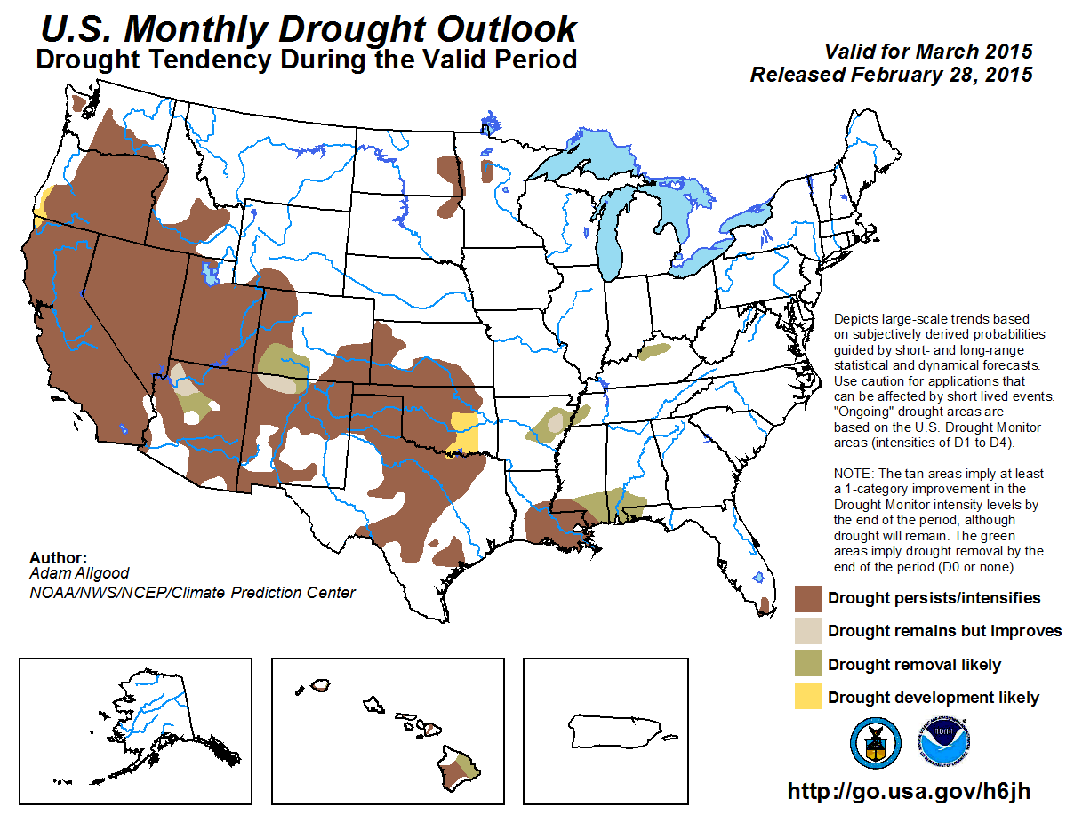
During late February, mostly dry weather returned to the Pacific Northwest and northern California, limiting any further
drought improvements. Localized precipitation fell across portions of the Southwest, although mostly dry conditions prevailed
across southern Arizona and New Mexico. Seasonably dry weather continued throughout most of the Plains states, while a series
of potent winter storms brought considerable rain, snow, and ice to the Tennessee and Ohio Valleys, easing drought conditions
across western Tennessee and much of Kentucky. In contrast, continued below median precipitation was observed across the
central Gulf Coast, where decreasing soil moisture and low streamflow values promoted drought expansion. During March, near
term precipitation over the West followed by a return to drier conditions is forecast during early March, with the updated CPC
monthly outlook tilting the odds towards below median precipitation across northern California, Oregon, and Washington.
Additionally, the CPC temperature outlook maintains enhanced chances for above normal temperatures. These outlooks, coupled
with a warming and drier March climatology, do not support any additional improvements across the West. Drought expansion is
also possible across parts of far northwestern California and southwestern Oregon. A potent winter storm is forecast to
impact the Four Corners states during early March, bringing much needed rainfall and mountain snow. While this precipitation
has the potential to bring short term localized drought improvements to northwestern Arizona, southwestern Colorado, and far
northern New Mexico, the overall longer term impact of this storm on widespread multi-year drought conditions is anticipated
to be relatively insubstantial. This is primarily due to the very low incipient snowpack conditions, low reservoir levels,
and an anticipated return to a warmer pattern later in the month which would promote early snow melt. Outside of higher
elevation areas that receive the heaviest precipitation, drought persistence is more likely during March across the Four
Corners. Climatologically dry conditions prevailed across most of the Plains States during February, and March is also a
climatologically dry month. With no significant tilt in the climate signals, drought persistence is anticipated for Texas,
Oklahoma, and Kansas. Additional drought development is possible over southeastern Oklahoma before climatological
precipitation increases later in the Spring. Across the East, additional widespread precipitation is forecast from more
winter storms across the Tennessee and Ohio Valleys, which is predicted to result in additional drought reduction. The
central Gulf Coast will likely miss out on this precipitation once again, although the updated CPC March outlook tilts the
odds towards above-median precipitation across the Southeast. Based on climatological drought reduction potential and the CPC
monthly outlook, drought removal is anticipated across most of Mississippi, Alabama, and the Florida Panhandle, while
persistence is favored over Louisiana and South Florida. Across Hawaii, an anticipated wetter pattern during early and
mid-March may bring some relief to the eastern portions of the Big Island and Kauai.
|
|
Tools used in the U.S. Monthly Drought Outlook (MDO) included the official Climate Prediction Center (CPC) updated
temperature and precipitation outlooks for March 2015,
various short- and medium-range forecasts and models such as the 7-day precipitation
totals from the Weather Prediction Center (WPC), the 6-10 day and 8-14 day CPC forecasts, week 3 and 4 experimental
outlooks, the NAEFS precipitation outlooks, dynamical models (CFSv2), the 384-hour total precipitation forecasts from
several runs of the GFS, climatology, the latest official Drought Monitor analysis (valid on February 24), observed
precipitation during the previous month, and initial conditions.
During late February, below average precipitation returned to the northern Sierras, coastal northern California, Oregon,
and Washington, while a storm system brought localized precipitation to portions of southern California, yielding minor
drought improvements. Little change in the situation has occurred since the release of the seasonal drought outlook.
Basin water year to date precipitation values are near normal across Washington and Oregon, but snow water equivalent
(SWE) values remain generally under 25 percent of normal. The Sierras received 50 to 75 percent of normal water year to
date precipitation, but SWE values are below 50 percent of normal. The lack of sufficient snowpack is largely due to
persistent above normal temperatures, which have kept snow elevations much higher than normal. Any winter precipitation
that has fallen has largely been rain, which yields more ephemeral benefits to reservoirs heading into the spring and
summer dry season than mountain snowfall. Over the next day or two, a storm system is anticipated to bring additional
precipitation to the West, with around an inch possible for far southern California, and up to 1.5 inches liquid
equivalent for the central Sierras. Similar amounts are anticipated across Washington and Oregon. A return to dry
conditions is anticipated during the late Week-1 and early Week-2 period, and forecasts are mixed during the remainder
of the month, with several models indicating a potential for above median precipitation. The CFS maintains a drier
signal across the West during March as a whole, and the CPC updated March outlook tilts the odds towards below median
precipitation across northern California, Washington and Oregon, due to both the anticipated drier conditions early in
the month and the CFS guidance. Most forecast guidance also favors above normal temperatures, which coupled with spring
warming would effectively limit additional snowpack building over the mountains. Climatological precipitation decreases
substantially over the West during March. Based on recent conditions including very low SWE values, and a decreasing
spring precipitation climatology, drought persistence or intensification is anticipated across the West. Additionally,
drought development is possible during March across coastal northwestern California and southwestern Oregon, which have
missed out on late February precipitation.
Forecast confidence for the West is moderate to high.
Localized above median precipitation fell across northeastern Arizona, southeastern Utah, southern Colorado, and
northeastern New Mexico during the second half of February, while mostly dry conditions prevailed across the remainder
of the Four Corners states, with a net effect of little change in drought conditions during the past week. Conditions
in the Four Corners region are similar to the remainder of the West, with generally below normal snowpack conditions
and low reservoir levels, particularly across Arizona and New Mexico. During the next week, a potent storm system is
forecast to bring widespread precipitation to the Four Corners region, with a deep trough in place supporting lower snow
elevations across the mountains. Liquid equivalent precipitation values across the higher elevations are forecast by WPC
to be as high as 6 or more inches across central Arizona and over 7 inches across southern Colorado. This anticipated
precipitation would be extremely beneficial for the region, and would help boost water year to date values to near or
above normal in many locations. It is uncertain, however, how much improvement this storm would generate for SWE values
over the southern Rockies, which are currently below 25 percent of normal across Arizona. Reservoir levels across
Arizona, New Mexico, Nevada, and southwestern Colorado also remain generally well below normal, similar to last
year. The CPC 8-14 day outlook returns precipitation probabilities to near normal. The CPC updated March outlook tilts
the odds towards above median precipitation across the Four Corners, mostly due to the short term forecast. March is a
climatologically dry time of year across the region. Based on the currently low snowpack and reservoir conditions,
improvements from the forecasted storm system are anticipated to be relatively limited, with persistence more likely
across most of the Four Corners region. Small areas of drought improvement or removal are depicted across the higher
elevations of northwestern Arizona, southwestern Colorado, and northern New Mexico, where WPC forecasts indicate the
highest precipitation amounts. It should be noted that these improvements may be rather short lived, as a continuation
of below normal SWE values has a greater impact on reservoir supplies later in the Spring and Summer
seasons. Accordingly, the latest CPC seasonal drought outlook maintains drought persistence across the entire Four
Corners region.
Forecast confidence for the Four Corners states is low.
A series of winter storms over the southeastern U.S. brought above median precipitation as far west as northeastern
Texas and far eastern Oklahoma, while below median precipitation was observed across the remainder of Oklahoma,
southeastern Kansas, and southern Texas. March is the climatologically driest Spring month across the central and
southern Plains, and it is unlikely that near median rainfall would have much of an impact on largely entrenched,
multi-year drought conditions across Texas, central and western Oklahoma, and Kansas. Light to moderate precipitation on
the western edge of additional winter storms is forecast for the eastern Plains during the next 7 days, while the CPC
8-14 day outlook tilts the odds towards below-median precipitation for Kansas, Oklahoma, and northern Texas. There
is not a clear precipitation signal from either the CFS or ECMWF during the Weeks 3 and 4 period, and the updated CPC
March outlook maintains equal chances for below, near, or above median precipitation. Based on climatology and these
outlooks, drought persistence is the most likely outcome across the central and southern Plains. Additionally, further
drought development over south-central Oklahoma is possible, based on recent dryness and low streamflow values.
Forecast confidence for the Plains is moderate.
Little change has occurred across the upper Midwest since the release of the seasonal drought outlook, with generally
near to below median precipitation observed during a climatologically dry time of year. The CPC 6-10 outlook tilts the
odds towards below normal temperatures, while the 8-14 day outlook indicates near normal temperatures. CFS and
ECMWF-based Weeks 3 and 4 forecasts generally support a continuation of near to below normal temperatures during late
March. Based on these forecasts, an early Spring thaw is not anticipated across the upper Midwest, and drought
conditions are likely to persist. Additional drought development is possible in this region due to below average snow
cover following a dry Fall season, but this deterioration is more likely to occur after the Spring thaw is underway
beyond this forecast period.
Forecast confidence for the upper Midwest is moderate.
During the previous two weeks, a series of winter storms have brought much above normal precipitation to the Tennessee
and Ohio Valleys, boosting soil moisture and streamflows, and reducing or removing drought conditions across western
Tennessee and much of Kentucky. A continuation of this cold and wet pattern is anticipated during the upcoming week,
with WPC 7-day forecasts indicating an additional widespread 2 to 4 inches of precipitation, with a somewhat drier but
continued cold pattern anticipated during the Week-2 period. The ECMWF and CFS Weeks 3 and 4 outlooks show a weak wet
signal during late March, and the CPC updated monthly outlook tilts the odds towards above-median precipitation across
much of Tennessee and Kentucky, largely based on the early month forecasts. Based on the short term forecasts and a
relatively wet climatology, further drought improvements are forecast for Arkansas, Tennessee, and Kentucky.
Forecast confidence for the Tennessee and Ohio Valleys is high.
Although widespread heavy rainfall, ice, and snow have fallen in recent days across the upper South, below median
precipitation was observed along the central Gulf Coast, where below normal soil moisture and streamflows have promoted
the expansion of D1 conditions into southern Mississippi, Alabama, and the western Florida Panhandle. Additional winter
storms may bring some precipitation to the region during the next 7 days, but the focus will continue to be well north of
the area. March is a relatively wet time of year across the Southeast. The CPC 6-10 and 8-14 day outlooks maintain
near normal probabilities of precipitation, while the Weeks 3 and 4 CFS and ECMWF forecasts both indicate a wet signal
towards the end of March. Accordingly, the updated CPC monthly outlook tilts the odds towards above-median
precipitation, favoring eastern portions of the drought areas. Therefore, drought removal is anticipated across much of
southern Mississippi, Alabama, and the Florida Panhandle based on a slightly wetter signal and greater probabilities of
drought amelioration based on NCDC March climatologies. Drought persistence is anticipated across southwestern
Mississippi and Louisiana, where climatology is somewhat less supportive of drought reduction. Drought persistence is
also forecast for interior South Florida, where March is a dry time of year.
Forecast confidence for the central Gulf Coast and interior South Florida is low to moderate.
A relatively dry winter season promoted expansion of abnormal dryness and drought across Hawaii. During the next several
weeks, dynamical models including the GFS, CFS, and ECMWF support a pattern change, with a plume of moisture extending
from the Date Line north of the equator northeastward across the Hawaiian Islands. The enhanced precipitation may ease
some of the shorter term drought conditions, particularly across the eastern portions of the Big Island and Kauai.
Forecast confidence for Hawaii is moderate.
|


