|
Tools used in the U.S. Monthly Drought Outlook (MDO) included the official Climate Prediction Center (CPC)
updated temperature and precipitation outlooks for November 2015, various short- and medium-range forecasts and models such as
the 7-day precipitation totals from the Weather Prediction Center (WPC), the 6-10 day and 8-14 day CPC Extended-Range Forecasts
(ERFs), Weeks 3 and 4 experimental outlooks, the NAEFS precipitation outlooks, dynamical models (CFSv2), the 384-hour total
precipitation forecasts from several runs of the GFS, climatology, the latest official U.S. Drought Monitor analysis
(released on October 29), observed precipitation during the previous month, and initial conditions.
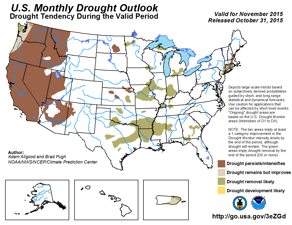
During late October, widespread heavy rain, partly associated with the remnants of Hurricane Patricia, fell across south-central
and eastern Texas, Louisiana, southern Arkansas, and the northern Gulf Coast, bringing rapid relief to short term flash drought
conditions, but also causing widespread flooding. In contrast, dry, warm conditions across the central Plains and mid-Mississippi
Valley promoted continued expansion of short term abnormal dryness and moderate drought conditions. A second round of widespread,
heavy rainfall occurred on October 30, with widespread observations between 1 and 3 inches (locally more than 5 inches) across the
southern Great Plains and westtern Gulf Coast region. Additionally, the WPC 7-day precipitation depicts widespread moderate to heavy
rainfall across the southern Great Plains to the middle Mississippi Valley. The CPC 6-10/8-14 day outlooks favor above median
precipitaiton across the south-central conus. Longer range guidance, including the CFS and ECMWF, maintain a wet pattern across the
southeastern quadrant of the CONUS through Weeks 3 and 4. Based on the very wet short term forecasts, and the prospects for
continued wetness throughout November, widespread drought removal, even of areas currently D2 or worse, is anticipated across the
southern Plains, Mississippi Valley, and the Southeast. Drought persistence is forecast for central and northeastern Kansas where
lower rainfall amounts are expected during the first week of November.
Forecast confidence for the southern and central Plains, southern and central Mississippi Valley, and the Southeast is high.
Since October 27, widespread beneficial rainfall, generally an inch above normal, fell across the upper Mississippi Valley and
eastern Corn Belt, which will likely ease short term drought conditions. Much less rainfall was observed across Minnesota and North
Dakota. During the upcoming week, additional rainfall (0.5 to 1.25 inch) is forecast for Illinois, southern Iowa and Wisconsin, and
southwestern Michigan. The CPC 6-10 day outlook maintains a wet pattern across much of the Midwest and Great Lakes region, although
a drier pattern is anticipated over the northern Plains. Longer range dynamical guidance for the Weeks 3 and 4 period are mixed, but
generally favor above-normal precipitation. Based on the shallowness of the existing drought conditions, recent beneficial rainfall,
a seasonal period that strongly favors soil moisture recharge due to little evapotranspiration, and forecasts for a near-normal to
wet November, drought removal is anticipated across the upper Midwest and Great Lakes region. Drier incipient conditions and
outlooks at all time scales favor drought persistence across North Dakota, with a slight chance for additional expansion during the
month.
Forecast confidence for the northern Plains, upper Midwest, and Great Lakes region is moderate.
As of the October 27 U.S. Drought Monitor, moderate drought conditions continue to persist from northern New Jersey through eastern
New England. During the past week, widespread rainfall fell across the northeastern U.S., with the highest amounts focused over the
higher elevations of interior New York and New England. In the existing drought areas, the heaviest rainfall fell across northern
New Jersey and western Connecticut. The recent rainfall is likely to ease drought conditions as it absorbs into the soils and boosts
streamflows. Therefore, removal of drought is likely across northern New Jersey and western Connecticut. Little rainfall (generally
below a tenth of an inch) is forecast during the next week across the remaining drought areas of the Northeast. Weeks 3 and 4 tools
generally depict a dry signal, and the CPC updated monthly outlook maintains enhanced chances for below-median precipitation across
parts of the Northeast. These outlooks are also consistent with El Niño composites for the October through December period.
Based on the potential for a drier than average November, persistence of the existing drought areas outside of the regions discussed
above is favored.
Forecast confidence for the Northeast is moderate.
During the past month, generally below average precipitation fell across the Pacific Northwest; however, the precipitation was
sufficient to ease drought conditions along Washington's northern Coastal Range and the far northern Cascades. A storm system is
forecast to bring widespread rainfall and mountain snows to the Pacific Northwest from October 31-November 3, with the highest
amounts across the higher elevations of the Coastal Range, Cascades, and northern Rockies. As is typical during these precipitation
regimes, a rain shadow is forecast east of the Cascades across east-central Washington. Based on the short-term precipitation,
additional improvements are possible across the Coastal Ranges in northwestern Oregon and western Washington, which are less
dependent on mountain snowfall. Persistence is favored elsewhere, and any continuation of a dry pattern beyond November would
promote redevelopment or re-intensification of drought conditions.
Forecast confidence for the Northwest is moderate.
October is a dry time of year for the Southwest, and status quo drought conditions persisted across California. In contrast, areas
of unseasonable rainfall across the interior Southwest brought localized improvements to parts of the Great Basin, desert Southwest,
and the southern Rockies. The updated November outlook maintains equal chances for below, near, and above median precipitation for
California, and above-median precipitation is favored across the Great Basin and southern Rockies. The monthly forecast is based
partly on the first week of the month, when a storm system is anticipated to bring widespread snow to the central and southern
Rockies, and rainfall at the lower elevations. Near to below-median precipitation is favored to return during the 8-14 day period.
Based on these outlooks, further localized drought improvements are likely; however, it is difficult at this time to determine which
local areas would receive the highest precipitation totals. In general, the areal coverage of persistence is anticipated to be
greater than the areal coverage of improvements, therefore, drought persistence is forecast in this outlook across the Great Basin
and southern Rockies. Persistence is also forecast across California, with the greater potential for significant drought
improvements occurring beyond November.
Forecast confidence for the Southwest is low.
Dynamical models depict mixed precipitation signals across Hawaii during November, although El Niño conditions favor
suppressed rainfall. There is currently no D0 areas across the islands, and in the absence of a strong dry signal during November,
2-category degradation necessary to achieve drought development is unlikely to occur by the end of the month. Therefore, no drought
development is forecast in this outlook, but areas of abnormal dryness could develop and expand during the period.
Forecast confidence for Hawaii is moderate.
During the next two weeks, widespread, heavy rainfall is forecast across Puerto Rico, which should result in additional drought
reductions. Beyond the Week-2 period, dynamical models do not forecast a pronounced wet or dry signal as the rainy season ends and
the dry season begins. Climate anomalies associated with El Niño favor above average rainfall across Puerto Rico during the
dry season. Based largely on forecasts for the first two weeks of the month and the El Niño composites, drought improvement
(and removal of D1 areas) is forecast for Puerto Rico.
Forecast confidence for Puerto Rico is moderate to high.
There are currently no drought areas in Alaska. Climatological precipitation decreases across the state during the Fall months, and
the updated November outlook favors above-median precipitation. Therefore, no drought development is anticipated for Alaska through
the end of the month.
Forecast confidence for Alaska is high.
|


