|
| |
 |
| |
|
October 2015
|
| |
|
Outlook Graphic: PNG PDF 
|
| |
|
Latest Monthly Assessment -
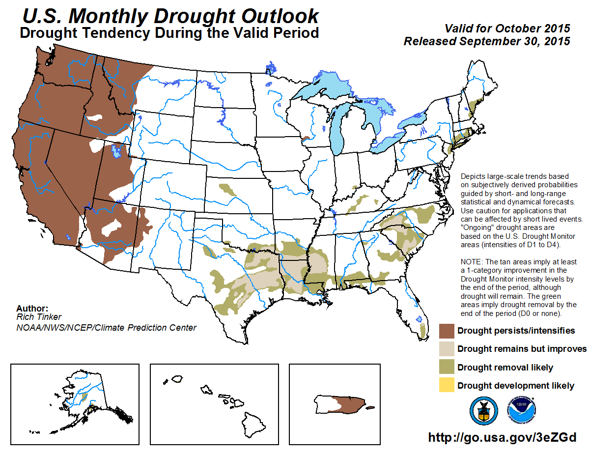
Since late August, the Drought Monitor indicates worsening dryness and drought prevailed across the central and eastern U.S., though there were some pockets of improvement. In particular, parts of the northern Plains, the Great Lakes region, the central and western Gulf Coast, Georgia, and southern Florida bucked the trend and showed more areas of improvement than deterioration.
In contrast, drought conditions eased in more than half of the dry areas in Alaska and Puerto Rico. In addition, improvement was significant and widespread across Hawaii, where excessive rains fell in association with two tropical systems. Reports of 10 times normal or more since late August were not uncommon, and drought is now relegated to small areas in southern sections of Kauai, Maui, and the Big Island.
Drought persisted with little deterioration or improvement from the Rockies to the Pacific Coast. Locally heavy rain brought pockets of improvement to western Washington, southern Idaho, southern and eastern Montana, and the southern Rockies while deterioration was limited to much of central Montana.
The October Drought Outlook is based on initial conditions, the updated October precipitation and temperature outlooks, climatology, and the expected effects of Hurricane Joaquin in the East. Located about 200 miles east-northeast of the central Bahamas on midday September 30, Joaquin is expected to meander westward or southwestward for the next couple of days before taking a turn to the north, with an increase in forward speed. Its eventual impact on the eastern U.S. will depend on how it interacts with a developing upper-level trough in the Southeast. Regardless of its track, heavy rain is expected along a frontal system at the beginning of October across parts of the East.
As far as the October Drought Outlook is concerned, improvement is expected in the East whether or not Joaquin makes landfall. Other short-term features, most notably and upper-level trough developing in the Southeast, should bring enough rain to promote improvement in any case. Joaquin is not likely to affect southern Florida at all, but moderate short-term rains and the potential for additional precipitation later in the month should continue the trend toward improvement that has been observed over the past several weeks.
In fact, most of the central and eastern U.S. should see at least some drought improvement, save the small area in southern Wisconsin, where the October precipitation outlook shows enhanced chances for below-normal precipitation.
Even more broadly, the first half of the month is expected to be wetter than normal for a large part of the contiguous 48 states. Only parts of the Southwest and Southeast are excluded from the generally wet outlook, and late September rains should be enough to promote improvement in the Southeast even if the region misses out on the anticipated wet spell. For the month as a whole, odds favor wetter than normal weather from most of the Four Corners states southeastward through Texas and Louisiana.
Drought is expected to persist from the Rockies westward despite expected above-normal rain early in the month outside central and southern California, and for the month as a whole in most of the Four Corners states. Drought dates back longer than in most of the East, and with the water year just getting underway, any precipitation should have negligible impact on the longer-term situation.
Drought is forecast to be removed from both Hawaii and Alaska by the end of the month, but should persist in central and eastern Puerto Rico. Enhanced rainfall may affect the Commonwealth next week, but there is a lot of uncertainty, and it is unlikely there will be widespread improvement.
|
| |
|
Discussion for the Monthly Drought Outlook
|
| |
|
Tools used in the U.S. Monthly Drought Outlook (MDO) included the official Climate Prediction Center (CPC) updated temperature and precipitation outlooks for October 2015, various short- and medium-range forecasts and models such as the 7-day precipitation totals from the Weather Prediction Center (WPC), the 6-10 day and 8-14 day CPC Extended-Range Forecasts (ERFs), weeks 3 and 4 experimental outlooks, the NAEFS precipitation outlooks, dynamical models (CFSv2), the 384-hour total precipitation forecasts from several runs of the GFS, climatology, the latest official U.S. Drought Monitor analysis (released on September 22), observed precipitation during the previous month, initial conditions, and forecasts for Hurricane Joaquin from the Tropical Prediction Center (TPC).
In the Northeast and the Carolinas, all eyes are on Hurricane Joaquin, which is likely to affect at least part of the region, though there is a small chance that it will remain offshore. However, as far as the October Drought Outlook is concerned, improvement is likely even if Joaquin's effects prove to be minimal. The Drought Monitor valid September 22, 2015 is the most recent at this time, and serves as the starting point for this Outlook. Outside anything Joaquin might directly deliver, enough rain has either already fallen or is expected to fall in the short-term to promote improvement.
Forecast confidence from the Carolinas northward through the Northeast is high.
Drought improvement is also anticipated in southern Florida, but with less certainty. Late September through early October, at least a couple inches of rain is expected across most of the area, which should be enough to provide continued improvement despite an expected decline in precipitation the second week of October. The October precipitation outlook does not favor enhanced dryness or wetness in the region.
Forecast confidence for southern Florida is moderate.
Drought is also expected to ease from the central and southern Plains eastward through Georgia and northwestern Florida. The odds favor above-normal precipitation for the month as a whole across Texas and Louisiana, and wet weather is anticipated region-wide during the second week of the month. Moderate to heavy late-September rains in southern Alabama, northwestern Florida, and eastern Georgia add to the chances for improvement there even though there is less certainty about enhanced rainfall the second week in October.
Forecast confidence from the central and southern Plains eastward through Georgia and northwestern Florida is high.
The small area of drought in southwestern Wisconsin is expected to persist, with marginally-increased chances for below-normal precipitation for the month as a whole. The potential for above-normal precipitation during the second week of October reduces forecast confidence.
Forecast confidence for southwestern Wisconsin is low.
From the Rockies westward to the Pacific Coast, drought should persist. This is a tricky forecast, balancing expected above-normal precipitation for some places and times with the long-term, entrenched nature of the drought in this region. In particular, the October precipitation outlook favors above-normal precipitation for the month as a whole in Arizona, New Mexico, and Utah. It is a neutral to slightly dry time of the year in this area, and the CPC soil moisture model's raw values increase slightly more often than they decrease across Utah in October. In addition, the second week of October should be wetter than normal across most of the Intermountain West, the Pacific Northwest, and northern California, although the outlook for the month as a whole favors neither wetter- nor drier-than-normal conditions. As in areas farther south, climatology is neutral or leans slightly dry. However, the bottom line is that, region-wide, this is just the start of the water year, and events during this single month should have only minimal impact on the long-term drought conditions covering the area. But confidence is tempered by forecasts favoring wetter-than-normal weather.
Forecast confidence is low in the Four Corners states, moderate in the rest of the Intermountain West, and high elsewhere.
A southerly wind flow may bring increased rainfall to much of Puerto Rico during the second week of the month, but there is considerable uncertainty regarding the location and amount of potential rainfall. Otherwise, it seems unlikely that enough rain will fall to bring significant improvement to the drought conditions that have been entrenched in eastern parts of the Commonwealth for many months.
Forecast confidence in Puerto Rico is moderate.
The small areas of drought in Hawaii are expected to be removed by the end of the month. On the heels of an exceptionally wet period extending from late August through much of September, odds favor above-normal precipitation for the month as a whole.
Forecast confidence in Hawaii is high.
Wet weather for part or all of the month in Alaska is expected to lead to the removal of the small areas of drought by the end of October. It is a relatively wet time of the year, especially in south-central Alaska, which enhances the chances for improvement.
Forecast confidence in Alaska is moderate.
|
|


