|
Latest Monthly Assessment -
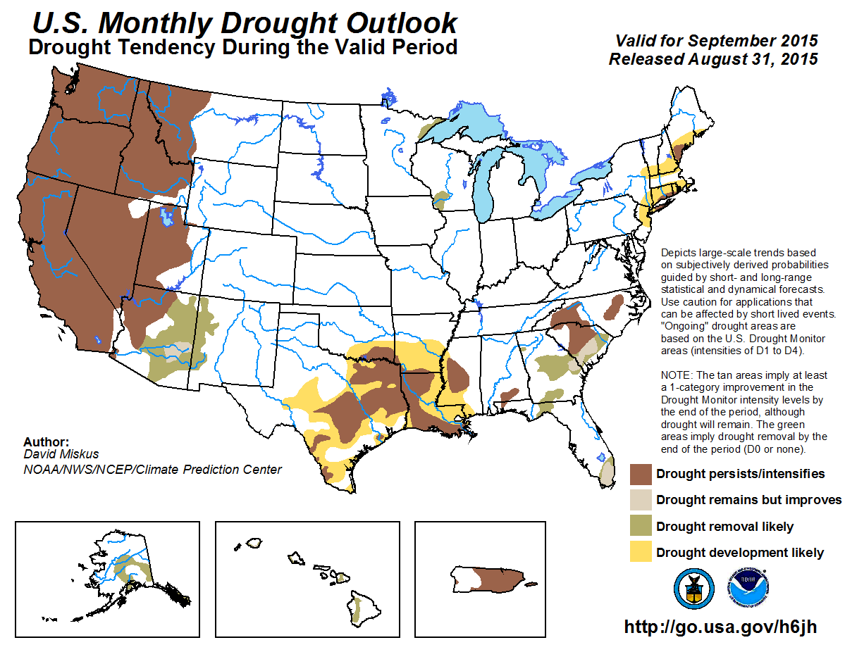
During August, limited drought improvement occurred across the Southwest, with drought intensifying over the Pacific Northwest
as numerous large wild fires charred much of the region. Short-term drought continued to affect parts of the Southeast
although some relief occurred in portions of Alabama, Georgia, and Florida. Meanwhile, subnormal rainfall and unseasonable
warmth persisted across the western Gulf Coast, southern Great Plains, and the lower Mississippi Valley, producing "flash
drought" in most of these areas after record wet May and June rains had eliminated long-term drought in the southern Plains.
Late in the month, however, heavy rains drenched portions of the western Gulf Coast, providing some drought relief. Increased
precipitation stabilized drought conditions in Alaska and Hawaii, but was not great enough to make any improvements.
Meanwhile, well below-average rainfall associated with the ongoing El Niño intensified drought across Puerto Rico during the
first half of August. After mid-month, however, moisture associated with Tropical Storms Danny and Erika increased rainfall
(1 to 5 inches) across most of the island, but storm totals were much less than forecast.
The monthly drought outlook valid for September is based on initial conditions, the updated CPC September precipitation and
temperature outlooks, and climatology. The most likely area for drought development across the lower 48 States is the southern
Plains and lower Mississippi Valley due to subnormal rainfall and high temperatures during July and August (flash drought),
and continued dryness and warmth expected during the first half of September. Similarly, some development is forecast for
parts of New England where D0 and D1 currently exist as sub-median rainfall and above-normal temperatures are predicted for
early September. Additionally, a dry fall signal is favored in New England during strong El Niño events. In contrast,
prospects for some drought improvement or removal increase across Florida and the southern Atlantic Coast as moisture from
the remnants of Erika combined with an upper-air low to the west have recently and are expected to drop ample rains on this
region during the next few days. Two small D1 areas in the upper Midwest are forecast for removal with recent heavy rains
(more than 2 inches) and forecasts of above-median precipitation at all September time periods (short, extended, and monthly).
Since September is climatologically dry and warm, persistence is very likely across the Far West (e.g. California, the Great
Basin, and Pacific Northwest). The tail end of the summer monsoon may provide beneficial rainfall to the Southwest,
especially in eastern areas where drought has been less in intensity and duration and September is still climatologically
wet (e.g. eastern Arizona, New Mexico, and west Texas). Since New Mexico and parts of eastern Arizona have experienced a wet
monsoon to date, these factors and expected short-term rains and odds for above-median monthly rainfall increase chances for
additional drought improvement/removal (e.g. short-term topsoil moisture) across these two areas. However, opportunities for
widespread major improvement to the hydrological drought (e.g. major reservoirs) across the Southwest are not expected until
the 2015-16 winter.
With September climatologically wet in Alaska, reduced temperatures, and widespread moderate to heavy August precipitation,
removal of drought is expected across interior Alaska and in the southeastern Alaskan Panhandle where even near-median
precipitation translates to large totals (10 to 20 inches) in the latter area. With recent and expected active tropical
activity in the central Pacific Ocean, widespread rains last week, and increased odds for above-median September rainfall,
improvement to the D1 and D2 areas are expected across the Hawaiian Islands. This would be welcome as strong El Niño events
typically bring dryness during the winter and spring. Suppressed convection, including a reduction of tropical cyclone
activity, is typical during El Niño summers across the Caribbean, and this has occurred in Puerto Rico and the U.S. Virgin
Islands. During late August, however, moisture from weak Tropical Storms Danny and Erika finally brought increased but less
than forecasted rainfall to parts of the island, limiting relief. With September normally wet and diminished tropical activity
expected to continue, persistence was predicted for Puerto Rico.
|
|
Tools used in the U.S. Monthly Drought Outlook (MDO) included the official Climate Prediction Center (CPC) updated
temperature and precipitation outlooks for September 2015, various short- and medium-range forecasts and models such
as the 7-day precipitation totals from the Weather Prediction Center (WPC), the 6-10 day and 8-14 day CPC Extended-Range
Forecasts (ERFs), Weeks 3 and 4 experimental outlooks, the NAEFS precipitation outlooks, dynamical models (CFSv2),
the 384-hour total precipitation forecasts from several runs of the GFS, climatology, the latest official U.S. Drought
Monitor analysis (released on August 27), observed precipitation during the previous month, and initial conditions.
A very dry September climatology (less than 2 percent of the annual precipitation) supports persistence across all of
California. Any drought improvement would be limited to southeastern California (currently in D0-D2) where late-season
Southwest monsoon moisture can occasionally push northwestward. And if a tropical cyclone develops in the East Pacific and
takes a similar track to Dolores, then a Pacific moisture surge could result in heavy rainfall across southern
California - although this is currently not expected.
Forecast confidence for persistence in California is high.
Drought persisted or intensified across the Pacific Northwest, Idaho, and western Montana last month as numerous large wild
fires continued burning. As of Aug. 29, the NIFC reported that 55 large wild fires affecting 1.64 million acres were active
across Washington, Oregon, Idaho, and Montana, roughly in the area where extreme drought (D3) was depicted in these states in
the Aug. 25 U.S. Drought Monitor. In addition, USGS 28-day averaged stream flows were at near- or record low levels across the
western thirds of Oregon and Washington, in northern Idaho, and northwestern Montana. During late August and early September,
the storm track will dip southward to bring precipitation along the U.S. and Canadian border including the Pacific Northwest,
but this rainfall is not expected to provide substantial drought relief (but should aid firefighters). And with favorable
chances of sub-median precipitation during the extended-range period (into mid-Sep) in the Far West, persistence is most
likely across the Pacific Northwest, Idaho, and western Montana. Wetter initial conditions and good odds for above-median
precipitation into mid-month should keep eastern Montana (some in D0) drought free through the end of September.
Forecast confidence for persistence across the Northwest is high.
According to the August 25 U.S. Drought Monitor, the coverage of drought (D1 or drier) in New Mexico decreased
from 36 to 13 percent while severe drought (D2 or worse) in Arizona dropped from 29 to 5.5 percent since June 2. Drought
coverage/intensity remained steady across the Great Basin. The active East Pacific hurricane season is expected to continue
due to the ongoing El Niño with the potential for additional Pacific moisture surges. Increased chances for above-median
rainfall are forecast during a climatologically wet time of year in eastern sections (eastern Arizona, New Mexico, and west
Texas). Ten to 17 percent of the annual precipitation occurs during September across this area. Despite the relatively strong
and consistent wet signal among successive model runs, persistence is forecast for most of the Great Basin and
Southwest. Widespread hydrological improvement is unlikely on a monthly time scale considering the long-term nature of the
drought, especially in western and northern locales. Winter snowpack will play a major role in the prospects for long-term
drought recovery. Improvement or removal of drought (mainly short-term topsoil moisture) is forecast for eastern Arizona and
New Mexico due to anticipated short-term rainfall and the wet southwest monsoon thus far.
Forecast confidence in the Southwest and Great Basin for persistence (western and northern areas) is high and improvement (eastern areas) is moderate.
Two small D1(S) areas lingered in parts of the upper Midwest (northeastern Minnesota and southwestern Wisconsin). But with
moderate to heavy rains falling on both the areas during late August, reduced September temperatures and evapotranspiration, a
slightly wet climatology, and near to above-median precipitation favored during all time periods (short, medium,
and monthly), removal of the D1(S) is probable by the end of September.
Forecast confidence for removal in the upper Midwest is moderate to high.
After record wet May and June rains virtually eliminated long-term drought across the southern Plains, a complete reversal of
conditions (very dry and hot) during July and into early August rapidly depleted the topsoil moisture, priming the region for
flash drought. During August, although temperatures were only slightly above normal, subnormal rainfall continued across much
of this region (except along the western Gulf), accumulating 60-day deficits of 4 to 8 inches and rapidly expanding short-term
dryness and drought across the southern Great Plains and the lower Mississippi Valley. Since near or below-median
precipitation and above-normal temperatures are expected to persist during the first two weeks of September, that September
is climatologically wet in south Texas, and the updated monthly precipitation outlook favors dryness in southern Texas,
persistence with expansion of the ongoing short-term flash drought is forecast for the southern Plains and the lower
Mississippi Valley. Although this September MDO forecast (persistence) is the opposite of the SON SDO outlook (improvement),
it is still probable that the ongoing strong El Niño will enhance the sub-tropical jet (increased storms and moisture) across
the southern tier of States later this year; however, this is more likely during the winter and early spring months and
possibly not by the end of November.
Forecast confidence of persistence and development for the southern Plains and lower Mississippi Valley is moderate.
Short-term dryness and drought continued across parts of Alabama, Georgia, and the Carolinas, with some areas improving while
others deteriorated since late July. During the past week, moisture from the remnants of TS Erika were funneled northward,
producing showers and thunderstorms across central Alabama, most of Georgia, and the eastern Carolinas. With the recent rains
and both short-term and extended-range forecasts favoring above-median rainfall, especially along coastal locations, some
improvement is expected here. In contrast, with less rain falling on central sections of the Carolinas during the past 60 days
and recently, persistence is favored for the inland areas of the Carolinas due to larger short-term deficits.
Forecast confidence for the Southeast is low to moderate.
Widespread moderate to heavy rains (2 to 5 inches) overspread much of Florida (except the Panhandle) during the past week as
moisture from the remnants of TS Erika were funneled northward by a upper-air low located over the central Gulf. With the WPC
7-day QPF indicating more than 2 inches statewide, somewhat favorable odds of above-median rainfall into mid-month, and a wet
climatology, these precipitation forecasts support drought improvement or removal across Florida, except persistence in the
western Panhandle where less rain has fallen in the short-term.
Forecast confidence for Florida is moderate.
Small areas of short and long-term drought (D1) continued across parts of eastern New England and Long Island, while a slight
expansion of D0 was recently added. With 30- and 60-day rainfall generally below-normal, 7-day QPF and 6-10 day ERF
(monthly precipitation forecast = EC) predicting above-normal temperatures and sub-median precipitation, and strong El
Niño events favoring a dry signal in the Northeast during the fall, persistence with some development in current D0
areas is most likely on a monthly time scale. However, the equally-distributed monthly precipitation climatology
(e.g. active weather year-round) makes it difficult for this region to stay dry for extended periods (months) of time,
throwing some uncertainty into this forecast.
Forecast confidence for persistence and development for the Northeast is low to moderate.
For Hawaii, there is a tendency toward wetter conditions during El Niño summers, then good odds for dryness during
the climatologically wet winter months. Tropically, the western and central Pacific Ocean has been very active this season,
although no storms have directly made landfall in Hawaii. With recent widespread rains during late August, the odds tilted
toward above-median September rainfall, and an expected continuation of the active Pacific hurricane season (e.g. Ignacio and
Jimena) possibly providing extra moisture to the islands, improvement of drought is forecast, with higher confidence on the
windward (east) side than the leeward (west).
Forecast confidence in Hawaii for improvement is low (leeward) to moderate (windward).
More than 70 percent of Alaska is depicted with abnormal dryness (D0) in the latest U.S. Drought Monitor (USDM) valid on
August 25, unchanged since the July 28 USDM. Moderate drought (D1) existed across east-central Alaska and the extreme
southeastern Panhandle. After a warm and dry spring and early summer that burned nearly 5 million acres this year, cooler and
wetter conditions during August have greatly diminished wild fires across the state, with only one active large wild fire as
of Aug. 31, according to NIFC. With September normally one of the wettest months statewide (transition from summer to winter
conditions), recent moderate to heavy precipitation statewide, lower temperatures and evapotranspiration, and favorable odds
of above-median precipitation into mid-month and for the month in western areas (EC east), drought removal is forecast.
Forecast confidence for removal in Alaska is moderate.
Although two tropical systems (Danny and Erika) impacted Puerto Rico and the U.S. Virgin Islands during late August, observed
totals were much lower than forecast. During Aug. 25-26, Danny produced 0.5-2 inches of rain on the eastern third of the
island, and less than 0.5 inches (many areas less than 0.1 inches) on the western two-thirds. During late August, Erika did a
bit better, dropping 2-6 inches of rain on interior central and eastern sections, but less than 0.5 inches in far western
portions. The rains were enough to halt a downward drought spiral, especially in eastern sections, but not enough to
significantly reduce drought conditions. Climate anomalies associated with El Niño strongly favor suppressed
convection and reduced tropical cyclone activity across the Caribbean, and this signal is supported by the latest dynamical
model guidance. Therefore, with expected persistent suppressed tropical activity during September (peak hurricane month and
wet climatology), drought is likely to persist across Puerto Rico. A September wild card would be an unexpected rogue tropical
system that slightly lowers the confidence level.
Forecast confidence for persistence in Puerto Rico is moderate to high.
|


