|
Latest Seasonal Assessment -
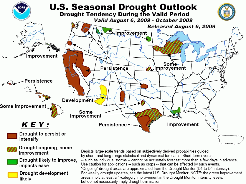
As southern Texas continues to struggle with an historic drought, there are indications that the drought may begin
to loosen its grip on some areas going into autumn. The beneficial impacts from the ongoing El Niño are usually
more pronounced in this region from November on, but long-range forecasts suggest decreasing odds for below-normal
rainfall by October. As a result, some improvement is forecast for parts of the Texas drought region over the next
3 months. Significant rains in the near term should contribute to drought improvement for southern Louisiana,
southern Mississippi, eastern North Dakota, northwestern Montana, and southeastern Alaska. Some improvement is
expected for the long-term drought affecting Wisconsin and parts of Minnesota, with substantial rains forecast
during early August. In the Pacific Northwest, some improvement is shown for the recently-developed drought in
Washington’s Olympic Peninsula, but the drought should persist over the interior areas. Continued drought is also
called for in California and parts of Nevada, while below-normal rainfall during the first half of August is
expected to contribute to drought development over southern and eastern Arizona, where conditions have dried out
quite sharply during the past several weeks. Below-normal rainfall during the latter part of the summer
thunderstorm season is expected to lead to persisting drought for parts of New Mexico. In the Pacific, Hurricane
Felicia’s forecast track could result in the storm affecting Hawaii by August 10-11. It is too early to know the
impacts, if any, from the storm given that this Outlook was prepared on August 5, but Felicia increases the
chances for significant rainfall and some drought relief over the Big Island and Maui.
|
|
Tools used in the Drought Outlook included the
official CPC precipitation outlook for August 2009 and the long lead forecast for August – October 2009,
the four-month Palmer drought termination and amelioration probabilities, various medium- and short-range
forecasts and models such as the 6-10 day and 8-14 day forecasts, the soil
moisture tools based on the GFS model and the Constructed Analogue on Soil (CAS) moisture, the
Climate Forecast System (CFS) seasonal precipitation forecasts, El Niño precipitation and temperature
composites for August-October, climatology, and initial conditions.
Parts of the Wisconsin-Minnesota
drought area are forecast to see substantial rains during the first week of the forecast period. Nevertheless,
the Drought Outlook indicates only some improvement because above-normal temperatures are expected to reduce
the benefits of the rain during the next 2 weeks, and the latest (August 5) CPC forecasts show the odds tilting
toward below-normal rainfall during the 6-10 day and 8-14 day period. Similarly, the weeks 1 and 2 CPC soil
moisture forecasts show the largest increases west and north of the drought area. El Niño composites for
August – October and soil moisture forecasts for October based on historic El Niño events indicate variable
conditions.
Forecast confidence for Wisconsin and Minnesota is moderate.
Forecast improvement for eastern
North Dakota is partly based on the wet outlook for the first 5 days of the period, and also on some seasonal
indications for improvement, including the University of Washington 3-month runoff and soil moisture probability
forecasts based on El Niño. In contrast, the Extended Range Forecasts from CPC look warm and dry, so some
resumption of dry conditions may occur after the first week. El Niño composites for August-October show a
tendency for above-normal rainfall in eastern North Dakota.
Forecast confidence for North Dakota is low.
Some improvement is shown for the
small drought area in Nebraska based on worsening conditions forecast for the first 2 weeks of the period
offset by increased odds for relief later in the season, as indicated by the CPC monthly and seasonal
precipitation outlooks. To the south, the lingering drought area in western Oklahoma is forecast to experience
mostly hot, dry weather during the next 2 weeks. The odds for relief later in the season appear somewhat less
than in areas farther to the north, and drought in this area is expected to persist, a more pessimistic
assessment than the previous Outlook.
Forecast confidence for Nebraska and Oklahoma is moderate.
In Texas, the lingering small
drought area in north Texas is forecast to experience hot, dry conditions during the first 2 weeks. There are
no strong seasonal forecast signals in this area from global forecast models or El Niño composites, although
the CFS soil moisture output does indicate increases in moisture by October. This Drought Outlook continues the
prior forecast for some improvement, but the odds for persistence may be nearly as high. Southern and
south-central Texas continues to endure one of their most intense droughts on record. The odds for significant
improvement increase considerably starting in November based on composites from historic El Niño episodes and
seasonal forecasts from the global models, such as the CFS, but the outlook into October is not as clear cut.
Monthly El Niño composites indicate the dry signal for southern Texas ends after September, while the CFS is
depicting above-normal rains for September. The weight of the evidence from the various seasonal models, El
Niño soil moisture composites, and forecasts from the short term out to the 3-month time periods suggests that
the odds for some improvement increase toward the north and the coast. As a result, persistence is shown for
the South Texas area, while some improvement is depicted across the northern and eastern parts of the drought
area.
Forecast confidence for north Texas is low and for southern and south-central Texas is moderate.
Subtantial rains during the first
2 weeks of the forecast period should virtually eliminate drought in southern Louisiana and southern
Mississippi.
Forecast confidence for Louisiana and Mississippi is high.
The latter part of the Southwest
monsoon season has been weak, especially in Arizona, where several areas have quickly dried out over the last
few weeks and are nearing drought status. With forecasts out to 2 weeks indicating a continuing lack of
significant rain, and with September-October typically drier climatologically, this Outlook presents a more
pessimistic picture for the Southwest, showing development in Arizona and persistence in New Mexico.
Forecast confidence in Arizona and New Mexico is moderate.
The Outlook continues to indicate
persisting drought in California and Nevada. Although the West Coast typically sees a pickup in rainfall during
October, little change in drought conditions is anticipated before December, when much larger increases in
precipitation typically occur. El Niño has the potential to bring above-normal precipitation this winter,
especially over southern California, as indicated in the CPC long-lead forecasts.
Forecast confidence for California and Nevada is high.
Unseasonably heavy rains during the
first 5 days of the forecast period should bring relief to the small drought areas in northwestern Montana. To
the west, lower rainfall amounts in the short term, along with the potential for autumn dryness due to El Niño,
keep the drought area over interior Washington in the persist category. Coastal rains should provide some
relief for the recently-developed drought on the Olympic Peninsula in Washington.
Forecast confidence for Montana is high and for Washington is moderate.
Normal to above-normal rains for
southeastern Alaska during the first 2 weeks, and the seasonal trend toward lower temperatures and more
precipitation thereafter result in a forecast for improving drought.
Forecast confidence for southeast Alaska is high.
The outlook for Hawaii is more
positive with this forecast, in part because the track of Hurricane Felicia toward the islands increases the
odds for significant rainfall in the August 10-11 time period. Since this Outlook is prepared on August 5, it
is not possible to know in any detail what the impacts, if any, will be from the storm, which is expected to be
weakening as it approaches the area. Given the range of possibilities over the next few days, not to mention
the ensuing 2 ½ months, the outlook shows some improvement for the Big Island and Maui. The prior forecast
depicted persistence for most of both islands. Although the odds for heavy rains appear to be greatest for the
southern islands, a more northward track by Felicia could bring substantial drought relief to areas farther
north. Looking out into autumn, a number of global numerical seasonal forecast models show increased odds for
rainfall near the Big Island during August-October, but not so for the islands to the north, thus the outlook
for some improvement over the Big Island considers the seasonal time frame as well.
Forecast confidence for Hawaii is low.
|


