|
Tools used in the Drought Outlook
included the official CPC precipitation outlook for December 2009 and the long lead forecast
for December 2009 - February 2010, the four-month Palmer drought termination and amelioration probabilities, various
medium- and short-range forecasts and models such as the 6-10 day and 8-14 day forecasts, the soil moisture tools based on
the GFS model and the Constructed Analogue on Soil (CAS) moisture, the Climate Forecast System (CFS) seasonal precipitation
forecasts, El Niño precipitation and temperature composites for December - February, climatology, and initial conditions.
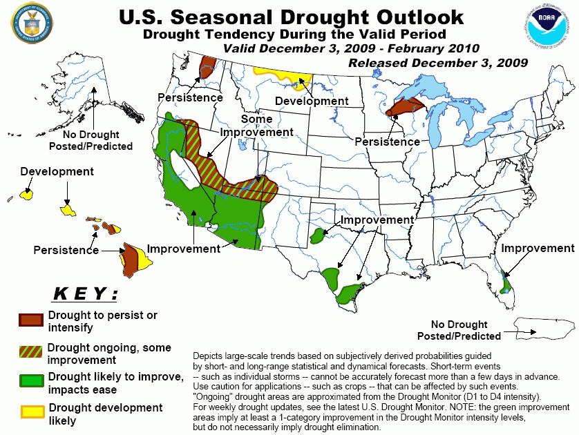
Short-term dryness has led to drought development
in east-central parts of the Florida peninsula. From October 1 – November 30, the rainfall deficit at Melbourne, FL is
nearly 7 inches. In the short-term, heavy rain (1 – 5 inches) is expected to fall over the Florida peninsula and may
eliminate drought conditions. Beyond the short-term period, the ongoing El Niño strongly favors above-median precipitation
during the winter and thus additional improvement is likely.
Forecast confidence for Florida is high.
Drought coverage and intensity has decreased in the
upper Mississippi Valley, but moderate to severe drought continues in northwest Wisconsin. Due to a lack of any forecast
signals for wetter than normal conditions and a relatively dry climatology during the outlook period, drought is expected to
persist. Precipitation for this region typically increases later in the spring.
Forecast confidence for Wisconsin is low.
Additional relief from the protracted drought
affecting parts of southern Texas appears likely during the winter. Forecasts from December through the end of February favor
above-median precipitation, and the development of moderate El Niño conditions also favors enhanced precipitation during the
outlook period.
Forecast confidence for Texas is high.
Short-term dryness earlier during the fall worsened
the drought in the desert Southwest and Four Corners Region, especially in Arizona. However, a winter storm at the end of
November resulted in locally heavy snow in southeast Arizona. From December 7 – 8, numerical models indicate an increased
likelihood for much needed precipitation across Arizona. El Niño composites indicate a tilt in the odds toward above-median
precipitation during the outlook period. The CPC seasonal forecast shows slightly increased odds for above-median
precipitation for southern Arizona but equal chances for above, below, or near normal precipitation across the reminder of
the State. With these considerations, improvement is more likely in southern Arizona.
Forecast confidence for the Southwest and Four Corners region is moderate.
Since October 13 when a very strong storm affected
northern and central California, drier than normal conditions have prevailed across the State. During the second week of
December, a pattern change featuring frequent periods of wet weather is expected. This expected increase in wetness is
consistent with a negative Arctic Oscillation (AO) and the current phase of the MJO. El Niño composites along with the CPC
seasonal outlook favor above-median precipitation during December – February. Typically, the storm track along the west coast
shifts south later in the winter. Due to these considerations, improvement is forecast across California.
Forecast confidence for California is high.
Due to rain and snow that occurred during late
November and forecasts of above-median precipitation during the 6-10/8-14 day period, the development area in northeast
Washington has been removed from the previous outlook. CPC seasonal forecast indicates higher odds for below-median
precipitation. Therefore, drought persistence is forecast in central Washington.
Forecast confidence for Washington is low.
Abnormal dryness currently exists across parts of
Montana. Due to this initial dryness and a few seasonal tools supporting either below-median precipitation or a decrease in
soil moisture, drought development is now forecast across parts of the State.
Forecast confidence for Montana is low.
Hawaii is forecast to receive below-median rainfall
during the upcoming winter, consistent with an ongoing El Niño. Drier than normal conditions will worsen existing severe to
extreme drought and likely result in drought expansion across the remainder of the State.
Forecast confidence for Hawaii is high.
|


