|
Latest Seasonal Assessment -
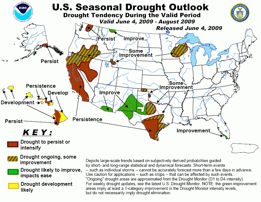
The early and dramatic start to Florida's rainy season has had a tremendous impact on the state's rivers, streams and
groundwater resources. Additional rainfall in the past week, along with robust rains predicted in upcoming weeks will have
all but eliminated the widespread, severe drought that had affected Florida until very recently. Across the southern Plains,
some improvement is on tap, especially for Oklahoma and northern Texas, while persistence of severe drought is likely for
southern Texas. In the Upper Midwest, some relief is expected from the long-term drought during the next few weeks. The trend
for developing dryness in South Dakota and Nebraska should be reversed in the next few weeks as a wetter pattern sets up.
Continued drought relief is forecast across the Southwestern U.S., largely because of the summer monsoon. For the West Coast,
rainfall in the next few weeks should be beneficial for the northern quarter of California, Oregon, and extending into the
northern and central Great Basin and Rockies. In Alaska, short-term dryness will likely persist over the southeastern portions
of the state, including the Panhandle, while increasing dryness is indicated over Hawaii.
|
|
Tools used in the Drought Outlook included the
official CPC precipitation outlook for June 2009 and the long lead forecast for June - August 2009,
the four-month Palmer drought termination and amelioration probabilities, various medium- and short-range forecasts and
models such as the 6-10 day and 8-14 day forecasts, the soil moisture tools based on the GFS model
and the Constructed Analogue on Soil (CAS) moisture, the Climate
Forecast System (CFS) seasonal precipitation forecasts, and climatology.
Within the last two weeks, much of the Florida peninsula has
received copious amounts of rain, with two feet of rain reported in northeastern parts of the state. This precipitation
event brought an early end to Florida's dry season, which had been abnormally dry to begin with. As a result of this event,
there has been a marked impact on rivers and groundwater supplies across most of the state, with many streams and rivers
running well above the 30-year normal for late May. Soil moisture anomalies for northeastern Florida (May 31) show surpluses
of 80-120 mm. Current topsoil moisture values from USDA (May 31) are especially wet, with only 7 percent of the state
reporting relatively dry conditions, compared with the latest five year mean value of 77 percent. The most recent 5-day QPF
issued by HPC (valid through June 8) calls for another 1.5 to 2.0 inches of rain to fall over most of the state, with
close to 4.0 inches possible over northern Florida. The extended-range (6-10 day and Week 2) rainfall forecasts issued by
CPC indicate near- to above-normal precipitation over the state, while the updated 30-day rainfall outlook for June 2009
calls for no significant tilt in the odds toward above-, near-, or below normal rainfall. For the June-August 2009 CPC
seasonal rainfall outlook, the odds are tilted toward wetter than normal conditions for peninsular Florida. Continued
improvement in residual drought conditions is forecast for Florida.
Forecast confidence for Florida is high.
For Texas, drought conditions persist across large portions of the
state despite recent shower and thunderstorm activity. Convection has been isolated, with individual storms dropping several
inches of rain across some central Texas counties. North and south of this band, rainfall deficits for the past month along
the I-35 corridor between Dallas and San Antonio have been just shy of 3.0 inches. Stream flows are running below to much
below normal across eastern and central Texas. As of May 31, regional soil moisture anomalies ranged from 60-160 mm below
normal. The 5-day QPF forecast issued by HPC anticipates light rain (0.10 inch) over west-central Texas, and up to 0.50 inch
over east-central Texas. The soil moisture anomaly changes for Weeks 1 and 2 predicted by the GFS model indicate increasing
dryness for most of the state. CPC's official extended-range rainfall forecasts, as well as the Constructed Analog Soil
moisture tool (CAS), are in general agreement with additional drying, especially for southern and western Texas. For this
Drought Outlook, the CAS tool predicts soil moisture for both the end of June and the end of August 2009. CPC's 30- and
90-day Outlooks (valid June 2009 and Jun-Aug 2009, respectively) are slightly more optimistic concerning southern Plains
rainfall, showing equal chances of below-, near-, and above normal precipitation. With the onset of the 2009 Atlantic
hurricane season several days ago and the typical onset of the Southwest Summer Monsoon in early July, it seems reasonable
to go with some improvement across western and eastern portions of Texas. In any event, the chances for dryness increase
across the south, while the best chances for any rain are across the northern part of the state. Some support for this
pattern (albeit weak) comes from ENSO-related precipitation analog years based on transitions from cold events to neutral or
warm events. Drought persistence seems to be the most reasonable forecast for western portions of south Texas. Some
improvement is indicated for western Oklahoma, though northern portions of the state are getting drier and will have to be
monitored.
Forecast confidence for Texas and Oklahoma is low.
Lack of plentiful rains continues to result in below-normal and
much below-normal stream flows from southeastern Minnesota and northern Wisconsin eastward into the U.P. of Michigan. As of
May 31, soil moisture anomalies in this region ranged from 40-80 mm below normal, with dry extensions into southeastern
South Dakota and eastern Nebraska. Incidentally, the University of Nebraska at Lincoln reported that year-to-date
precipitation at Lincoln is only 3.89 inches (36 percent of normal), and is the third driest since 1887. Omaha has fared
somewhat better, with 5.63 inches of precipitation being reported for the same period, which is 51 percent of normal. Dry
short-very short topsoil moisture (from USDA, May 31) affects one-half (50 percent) of Minnesota and 48 percent of South
Dakota, compared with the latest 5-year mean values of 9 percent and 20 percent, respectively. Groundwater supplies/wells
continue to be low, due to what has been a very persistent, longer-term drought (about one year). Rainfall deficits for the
past 12 months range from 6.4 inches at Wausau, Wisconsin to 8.2 inches at Minneapolis. For the next 5 days, QPF values
between 0.10 inch and 0.50 inch are indicated for the driest areas, with higher rain totals predicted to the south across
the Corn Belt. The Upper Midwest in general has missed out on the heavier precipitation events for some time, with storm
tracks displaced either too far south or too far west. The extended range forecasts indicate beneficial rains for much of
this region. The CPC updated rainfall outlook for June also suggests short-term precipitation may help to temporarily offset
worsening drought conditions, though the 90-day outlook for Jun-Aug 2009 shows no definitive tilt towards any particular
category (tercile). The CAS tool projects further deterioration of conditions during the summer.
Forecast confidence for the Upper Midwest is moderate.
Across the Southwestern U.S., recent heavy rains helped ease
drought conditions in the region. These rains fell during the height of the climatological dry season. Superficially, the
rainy pattern resembled an early onset of the summer monsoon. However, further analysis reveals that an unusually amplified
east Pacific ITCZ and an upper-level trough approaching the Southwest from the Pacific, combined to pull moisture northward
into Mexico and the Western U.S. 5 to 6 weeks earlier than usual. The 5-day QPF indicates very light rain over eastern and
central New Mexico (some of which may not even reach the ground), with no appreciable amounts of rain forecast in Arizona and
southern California. The official 6-10 day and Week 2 rainfall forecasts issued by CPC call for little if any precipitation
across the Southwest. The updated June 2009 outlook shows no discernible tilt in the odds towards below-, near-, or above
normal rainfall, and climatology favors improving conditions for later in the summer.
Forecast confidence for the Southwest is moderate.
For the Western U.S., precipitation during the last 2 weeks has
been widespread but light (0.10 inch to 0.50 inch) across the region. Western portions of both Washington and Oregon have
precipitation deficits ranging from 0.50 inch to 2.00 inches during this period. The 5-day QPF forecast (valid through June 8)
shows rain extending from the Columbia River basin southward across Oregon, the northern half of California, and northwest
Nevada. The heaviest projected rain totals (2.0 inches) are indicated over southern Oregon and far northern California,
extending into the Sierras. After reassessing the situation in California, it is thought that rains expected in the near-term
will help only the northern quarter of the state and the Sierras, but is unlikely to provide substantial relief for water
supplies. Up to 1.50 inches of rain is expected in a band across central Idaho, northern Wyoming and southern Montana. The
CPC extended-range forecasts call for above normal rainfall for the interior Northwest and northern Rockies, with some of
this region expected to receive above normal rainfall for the month of June, according to CPC's updated monthly forecast.
This updated 30-day forecast has the benefit of NWP model guidance through the first half of the month. At this time, it
seems premature to indicate drought development and/or expansion across Washington state, though the June-August 2009
seasonal rainfall outlook calls for drier than normal conditions across the Northwest.
Forecast confidence for the West is moderate.
In southeastern Alaska and the Panhandle region, conditions remain
fairly dry despite recent precipitation. Precipitation deficits over the past 30 days include 6.5 inches at Yakutat, 2.3
inches at Sitka, 2.2 inches at Ketchikan, and a more modest rainfall deficit of 0.5 inch at Juneau. Stream flows are
currently near-normal across the Panhandle, though much of this is due to melting ice and snow and not as much from falling
precipitation. CPC rainfall forecasts out to one month in advance are supportive of relatively dry conditions for both the
Panhandle and southeastern Alaska.
Forecast confidence for Alaska is moderate.
In Hawaii, below to much below normal stream flows are reported
across the Islands, with little in the way of recent rainfall. Dryness has been increasing across this region during the last
few weeks, and is what would be expected given Hawaii is now in its dry season. The Outlook calls for persisting and
expanding drought due to the CPC seasonal forecast indicating the odds are tilted toward below normal rainfall. By far, the
largest rainfall deficit for the past 30 days has been at Hilo on the Big Island (5.4 inch deficit).
Forecast confidence for Hawaii is high.
|


