|
Latest Seasonal Assessment -
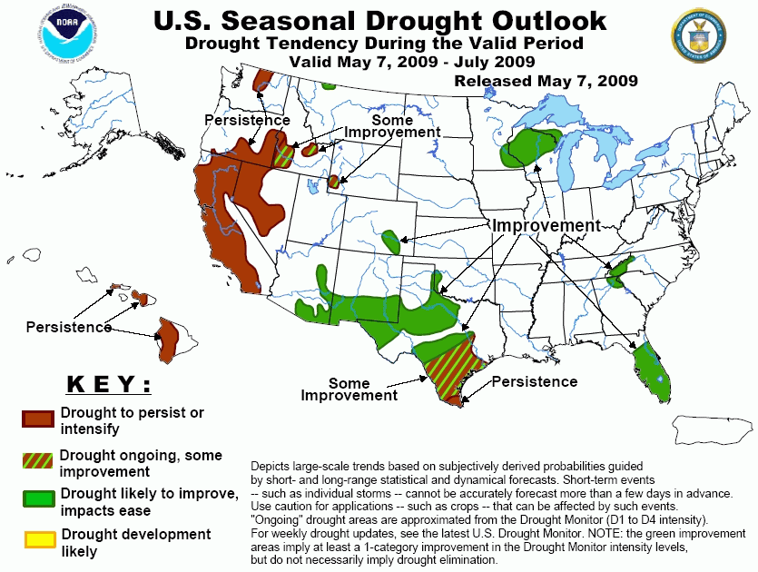
Over the last month, widespread moderate to heavy precipitation has eliminated or reduced drought severity in the middle Atlantic
States, the Great Lakes region, parts of the south-central Plains, portions of the Intermountain West and adjacent Rockies, and
the central Sierra Nevada. Most notably, intense rainfall was observed in parts of the southern Plains along the central Red River
Valley and the eastern tier of the drought region in Texas, where 10 to 20 inches were reported in a few areas. In addition,
unusual (though not unprecedented) late-season precipitation brought at least short-term improvement to parts of central and
northern California during the first few days of May, though no significant, widespread headway was made against the moisture
shortages that have accumulated over the course of the last 3 years in the region. In contrast, drought persisted or intensified
in other parts of the West, across the southern Rockies, in southern Texas, and through southern Florida since mid-April. From now
through the end of July, continued improvement is expected in the drought areas covering the western Great Lakes region, the
southern Appalachians and adjacent areas, and the Florida Peninsula, though in the latter region conditions may get worse over the
next several weeks before the seasonal rainfall increase gets underway sometime in June. Similarly, a hot and dry pattern in the
short-term could exacerbate drought in the southern Plains and Rockies before conditions become more favorable for significant
rainfall around mid-May in the south-central Plains and southern High Plains, and during June or July when monsoonal rainfall
typically picks up in the southern Rockies. Farther west, some improvement is forecast for portions of the interior West, but the
low precipitation totals typical of this time of year should keep drought entrenched in the Far West and in existing areas of
drought across Hawaii.
|
|
Tools used in the Drought Outlook included the
official CPC precipitation outlook for May 2009 and the long lead forecast for May - July 2009,
the four-month Palmer drought termination and amelioration probabilities, various medium- and short-range
forecasts and models such as the 6-10 day and 8-14 day forecasts, the soil moisture tools based on the GFS
model and the Constructed Analogue on Soil (CAS) moisture, the Climate Forecast System (CFS) seasonal
precipitation forecasts, and climatology.
Several inches of precipitation are forecast in the short-term for
the last vestiges of the once expansive drought that covered the interior Southeast. Given the expected heavy precipitation
through the forthcoming weekend, and nothing indicating enhanced probabilities for significantly below-normal rainfall
through the end of July, it seems likely that we will finally be able to close the books on this protracted and at one time
serious, large-scale drought that has been affecting the Southeast for the last 3 years.
Forecast confidence across the interior Southeast is high.
Across Peninsular Florida, improvement is forecast by the end of
July based on the expected onset of the annual wet season during the latter half of the forecast period, and the fact that
climatologically this seasonal increase in rainfall has proven quite reliable. Certainly the beginning of the wet season in
June and July could as easily feature below-normal precipitation as it could near- or above-normal totals, but a moisture
increase relative to the drier weather typical of the first several months of the calendar year almost always unfolds by
early summer, and the array of precipitation amounts measured during this period historically is fairly narrow, increasing
confidence that at least substantial surface moisture improvement will be observed by the end of July. It should be noted,
however, that it will be several more weeks before this seasonal increase in moisture and rainfall should be expected, and
with near or below normal precipitation forecast through at least mid-May, there is a good chance that drought conditions
will worsen before they get better later in the period.
Forecast confidence across Florida is high.
Significant precipitation is expected across the central and
western Great Lakes region through mid-May. In addition, May-July is typically among the wetter 3-month periods of the year,
particularly in central and western sections of the current drought area, so there should be additional opportunities for
drought improvement following the generally wet weather anticipated for the next two weeks. As a result, improvement is
forecast.
Forecast confidence across the Great Lakes region is high.
In central and southern Texas, some improvement is forecast for
most of the region, though a small area of drought persistence is anticipated across Deep South Texas. The forecast for this
region is particularly difficult. For the first 10 days of this forecast period, through May 16, 2009, dry weather and
above-normal temperatures appear likely. Thereafter, the indicators are contradictory. During week 2, a frontal system is
expected to tap tropical moisture and bring above-normal precipitation to areas farther north and west, and this weather
complex may, or may not, bring significant precipitation into south-central and southern Texas during this period, with the
chances for significant precipitation decreasing as one moves south and west through this drought region. Similarly, updated
guidance for the May - July 2009 period present an array of possibilities with no clear consensus. Climatologically, this
period tends to lean increasingly wet relative to other 3-month periods during the year as one moves north and west across
the region. Given the broad array of potential developments, and the neutral to somewhat wet May - July climatology, a
compromise forecast for some improvement seemed most prudent, except in Deep South Texas. In this area, the chances for a
substantial increase in precipitation come mid-May appear lower than for areas farther north and west, and at least some of
the tools indicating that May - July could end up wetter than normal show less precipitation (or a smaller likelihood of
above-normal precipitation) here than in the remainder of the area. The bottom line is that, after the first 10 days of the
forecast period, the outlook is rife with uncertainty.
Forecast confidence across central and southern Texas is low.
Across northern Texas and adjacent Oklahoma, and for drought areas
in the southern High Plains and Rockies, drought conditions are expected to improve by the end of July. In the relative
short-term, conditions may well deteriorate in many of these areas through mid-May 2009 as an upper-level ridge of high
pressure is expected to build across the region, accompanied by unusually high temperatures and little precipitation outside
of the easternmost fringes of the drought region. Thereafter, conditions look to improve, at least from New Mexico eastward.
Around mid-May, a frontal boundary is expected to tap tropical moisture and bring a swath of substantial rainfall to this
region which may well last into the latter part of the month. Looking at the longer-term, May - July is one of the wetter
times of the year from central New Mexico and western Texas eastward to north-central Texas, with monsoon-related rainfall
typically on the increase later in the period. Farther west across southern and eastern Arizona, precipitation through
mid-May is not expected to be as heavy, and monsoon-related precipitation commonly has a later and less robust onset than in
New Mexico and points east, so forecast confidence in this area is reduced.
Forecast confidence across the southern Plains is high westward through southeastern Colorado and central New Mexico, and
moderate across southwestern New Mexico and southern Arizona.
In northern Montana, above-normal precipitation anticipated through
the first 10 days of the forecast period, and May - July precipitation totals are typically abundant relative to the rest of
the year. Thus, drought conditions are forecast to improve.
Forecast confidence in northern Montana is high.
Scattered areas of drought across the Intermountain West and far
western Rockies should experience some improvement by the end of July. The first few days of the forecast period should
feature light to locally moderate precipitation, with a developing upper-level trough of low pressure along the West Coast
then expected to trigger above-normal precipitation into mid-May 2009. Unlike areas farther to the west and east,
May - July is not typically a particularly wet or dry time of the year in these drought areas, indicating that there should
be at least some subsequent opportunities for significant precipitation before the end of July, though the nature of the
eventual 3-month precipitation totals are far from certain, and could vary markedly with location given the region's terrain.
Forecast confidence across the Intermountain West and western Rockies is low.
May - July is normally quite dry compared to other times of the
year along the West Coast states and, to a lesser extent, in most of the drought areas in Nevada. With no strong indication
that the next few weeks should be wet enough to provide anything other than transient relief, drought seems likely to persist
through the end of July across Nevada, California, southern Oregon, and northern Washington.
Forecast confidence in the Far West is high.
Similar to forecast considerations in the westernmost contiguous
United States, late spring and early summer is a relatively dry time of year for Hawaii, so the odds for substantial relief
in areas of ongoing drought seem low, and drought here is expected to persist through July.
Forecast confidence in Hawaii is moderate.
|


