|
Tools used in the Drought Outlook
included the official CPC precipitation outlook for November 2009 and the long
lead forecast for November 2009 - January 2010, the four-month Palmer drought termination and amelioration probabilities,
various medium- and short-range forecasts and models such as the 6-10 day and 8-14 day forecasts, the
soil moisture tools based on the GFS model and the Constructed Analogue on Soil (CAS) moisture, the Climate Forecast
System (CFS) seasonal precipitation forecasts, El Niño precipitation and temperature composites
for November - January, climatology, and initial conditions.
Within the past two weeks, several
frontal systems have pushed across the Southeastern states, as far south as north-central Florida. Much of
South Carolina and Georgia have received rainfall surpluses during this period ranging from 2 to 4 inches,
and locally as much as 5 inches. However, a significant portion of North Carolina has 1 to 2 inch deficits
for the same two week period, which equates to only 10 to 25 percent of their normal rainfall. From a
historical standpoint, stream and river flow values throughout much of the state currently fall within the
lowest quartile. From a different, more optimistic perspective, the latest (Oct 11) USDA topsoil moisture
maps reveal that approximately 14 percent of North Carolina is reporting short-very short conditions,
compared with 33 percent for the past 5-year mean. CPC precipitation forecasts in general support additional
improvement in drought conditions in the Carolinas. Elsewhere, dry conditions have largely dominated the
central Appalachians for at least the past few weeks, with spotty relief for a few areas. One to two inch
rainfall deficits have been noted, and stream flow values for the period are within the lowest quartile in
western portions of Virginia. HPC's precipitation forecast for the next five days calls for 2 inches of rain
across the central Appalachians.
Confidence for the East Coast states: High
For the Southern Great Plains, the
main headline has been the recent rains in Texas and Oklahoma, which essentially wiped out the short-term
drought in many areas. It is important to note, however, that longer-term drought still exists in southern
Texas and more rain will be needed to replenish groundwater supplies and reservoirs. Rainfall surpluses for
the past two weeks across central and eastern portions of both Texas and Oklahoma (excluding southern Texas)
has generally been 2 to 3 inches, with 4 inch or greater surpluses over a fairly wide area. In contrast, 1 to
2 inch rainfall deficits dominated southern Texas, and somewhat smaller deficits continued across eastern New
Mexico. Stream flows generally registered near or above normal across the lower (eastern) southern Plains,
but below normal across the southern High Plains. CPC's extended and long-range precipitation forecasts call
for above median precipitation across the southern Plains. In the central Plains, slight dryness persisted
across extreme southeastern Nebraska, which has helped with late season harvesting of corn and other crops.
Most of Nebraska, however, has done well (in terms of rainfall) relative to climatology. The Northern Plains
have also benefited from recent rains during the past two weeks. One to two inch precipitation surpluses
brought some relief to the Dakotas, with 2 to 3 inch surpluses reported in eastern South Dakota. Very modest
surpluses were noted in southwestern North Dakota. Stream flows were at or above the 90th percentile across
the eastern Dakotas, and close to normal for western areas.
Confidence for the southern Plains: High
Across the Upper Midwest, welcome
rains have fallen across a large portion of the drought areas. A broad area of 2 to 4 inch (or more)
surpluses across central and southern Minnesota, northwestern and northeastern Wisconsin and western upper
Michigan, has made a substantial dent in the drought in these areas. Northern Wisconsin still needs
significantly more rain to bring this long-term drought (of well over a year) to an end. The northern
portions of Minnesota have missed out on these recent rains, showing deficits between 0.5 and 2 inches for
the past 2 weeks. Streams and rivers are generally running near to below average from the Arrowhead region of
northern Minnesota southeastward across northern Wisconsin and adjacent upper Michigan. The HPC QPF rainfall
forecast for the next five days calls for light rain (0.25 inch or less) across the driest areas of northern
Minnesota and northern Wisconsin, but between 0.5 and 1.0 inch for most of the remaining upper Midwestern
areas. The Constructed Analog Soil Moisture (CAS) forecast shows continued dryness for the region at the end
of November 2009, and dryness/drought is predicted to be even more pronounced by the end of January 2010.
USDA short-very short topsoil moisture values for the uppermost 6 inches of soil indicates Minnesota's
current state value of 17 percent is only slightly drier than the 5-year mean of 14 percent. For Wisconsin, a
state-wide value of 26 percent is actually slightly wetter than the previous 5-year mean of 31 percent. CPC's
30-day and 90-day outlooks indicate equal chances of below-, near-, and above median precipitation. Given
this uncertainty, as well as the tendency this area has had for missing out on the heavier precipitation
amounts, it is thought that some improvement may be the best forecast for portions of northwestern Wisconsin
and northern Minnesota.
Confidence for the Upper Midwest: Moderate
Recent heavy rain and mountain snow
in the northern Rockies has helped considerably in trimming back D0 dryness in southwestern Montana. Slight
precipitation deficits for the past two weeks were noted in northwestern Montana and northern Idaho, with 1
to 2 inch deficits for western parts of Washington and Oregon. Stream flows were predominantly normal in the
interior Pacific Northwest, and below normal near the Pacific Coast and northern Idaho. CPC's extended-range
forecasts out through the next two weeks calls for near to above median precipitation across the Northwest,
but below median for the 30-day and 90-day outlooks. Overall, the odds appear tilted toward persistence of
dryness/drought for the region, though the area of drought development which was indicated on the previous
Outlook over east-central Washington looks too risky, especially given short- and extended-range predictions
of near to above median precipitation.
Confidence for the Pacific Northwest/Northern Rockies: Moderate
Recent heavy rain and mountain snow
in northern and central California has brought some relief to the region unusually early in the rainy season,
but ongoing reassessment will be needed to determine exactly how much mitigation has occurred. CPC's monthly
forecast for November 2009 calls for equal chances of below-, near-, and above median precipitation, but for
the upcoming Nov-Dec-Jan 2009/10 season, CPC's outlooks call for wetter than median conditions across the
state. The weak to moderate El Nino anticipated this upcoming winter does not provide much help in tilting
the odds towards wet or dry. Up until the last 5 or 10 years, it was common for strong warm events to be
connected to unusually heavy precipitation events in California, especially later in the winter season, but
recently this correlation has not been very cooperative. Across the Southwest, drought has been expanding
and intensifying during the summer and into early autumn. For the past 90-days, 2 to 6 inch rainfall deficits
have mounted, primarily because of an unusually weak summer monsoon. For Arizona as a whole, this corresponds
to 25 to 50 percent of normal rainfall. Northern Arizona in particular has received only 10 to 25 percent of
its normal rainfall. The CAS tool predicts the drought to continue through November 2009 and even throughout
the Nov-Dec-Jan 2009/10 season. A consensus of various soil moisture models/tools from the CFS (experimental),
the NASA NSIPP model, the University of Washington VIC model, and CPC ENSO Soil Moisture Composites, provides
at least reasonable (but by no means unanimous) support for this Drought Outlook.
Confidence for California and Arizona: Low to moderate
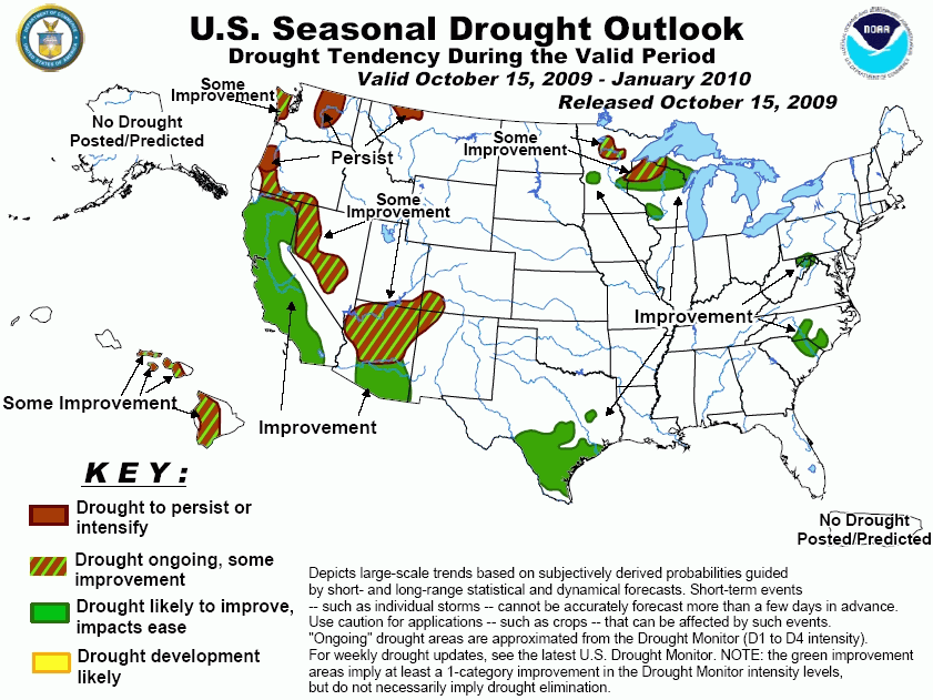
For Hawaii: With the approach of the
rainy season, most areas are expected to see at least some improvement.
|


