|
Tools used in the Drought Outlook
included the official CPC precipitation outlook for September 2009
and the long lead forecast for September – November 2009, the four-month
Palmer drought termination and amelioration probabilities, various medium- and short-range
forecasts and models such as the 6-10 day and 8-14 day forecasts, the soil moisture tools
based on the GFS model and the Constructed Analogue on Soil (CAS) moisture, the Climate
Forecast System (CFS) seasonal precipitation forecasts, El Niño precipitation and temperature
composites for September-November, climatology, and initial conditions.
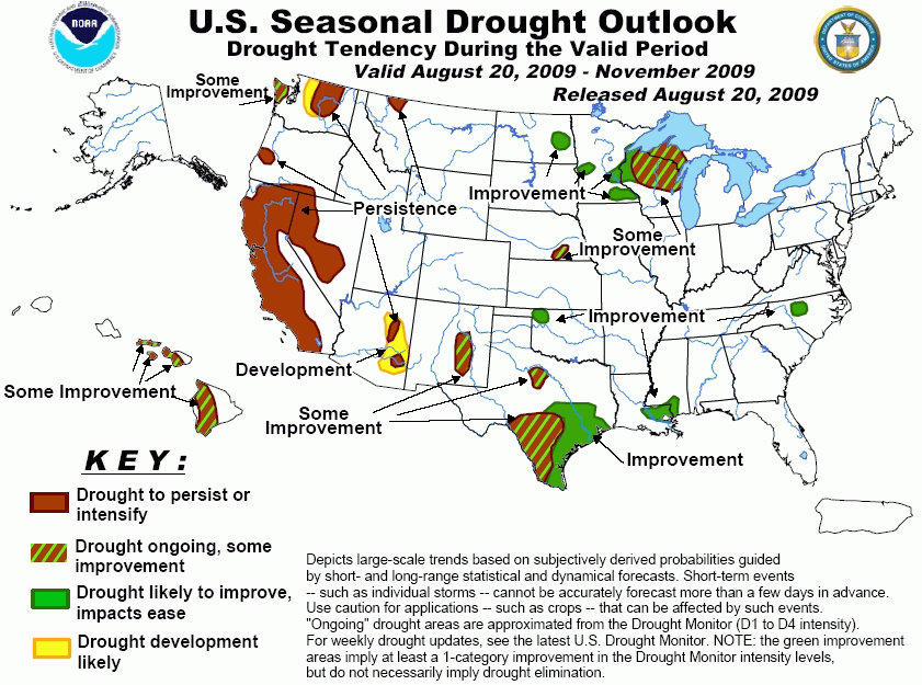
Following heavy showers during the
onset of the forecast period, the Wisconsin-Minnesota drought area is forecast to see only light precipitation
during the short range period. The CPC 6-10 day and week 2 forecasts indicate below normal precipitation for
the region while the 30-day forecast for September and the 90-day forecast for September-November show equal
chances for each of the precipitation categories during those periods. The CFS forecast for September-November
indicates near to above normal precipitation while the El Nino composites for the same period show near to
below normal precipitation for the region. Various soil moisture tools suggest the region will see some
improvement over the next three months. For these reasons a forecast of some improvement will be continued
for the region, except for those western areas where the heaviest rains are expected during the early part of
the period.
Forecast confidence for Wisconsin and Minnesota is moderate.
For eastern North Dakota moderate
rains have recently occurred over the drought area. The Hydrometeorological Prediction Center (HPC) forecast
for days 1-5 depicts light precipitation over the area, although the latest 0z and 6z runs of the GFS model
show little to no precipitation and the 6-10 day and 8-14 day forecasts from CPC indicate below normal
precipitation. The CPC monthly and seasonal precipitation outlooks indicate equal chances for each of the
possible precipitation categories. El Niño composites for SON suggest above normal precipitation, while the
Climate Forecast System (CFS) forecast for September-November is for near to above normal precipitation for
the region. For these reasons a forecast of improvement will be retained for the area.
Forecast confidence for North Dakota is low.
For Southeast Nebraska, the area
has recently received significant precipitation. Short and medium ranges forecasts suggest the area will
receive little additional precipitation over the next two weeks. The 30-day forecast for September and the
90-day forecast for September-November show equal chances for each of the precipitation categories during
those periods. The CFS forecasts and El Nino composites for September-November indicate a likelihood of near
to above normal precipitation for the region. For these reasons a forecast of some improvement is indicated for
the region.
Forecast confidence for Nebraska is moderate.
In northwestern Oklahoma, recent
precipitation has eased drought conditions somewhat. For the next two weeks, forecasts suggest little to no
precipitation over the area. According to the CPC forecasts for September and September-November, there is
little tilt in the odds for a given precipitation category. The CFS forecast for September-November shows above
normal precipitation for the region, while El Niño composites indicate near to above for the region. For these
reasons the region is forecast to show improvement.
Forecast confidence for Oklahoma is moderate.
In Texas, the lingering small
drought area in north Texas is forecast to experience near normal temperatures and little precipitation during
the first two weeks of the period. CFS forecasts suggest above normal precipitation for the region while El
Niño composites indicate mostly near normal conditions. For these reasons a forecast of some improvement
is indicated. Southern and south-central Texas continues to endure one of their most intense droughts on record.
The odds for significant improvement increase considerably starting in November based on composites from
historic El Niño episodes and seasonal forecasts from the global models, such as the CFS, but
the outlook into October is not as clear cut. Monthly El Niño composites indicate the dry signal for
southern Texas ends after September, while the CFS is depicting above-normal rains for September over the
western portion of this drought region. The weight of the evidence from the various seasonal models, El Niño
soil moisture composites, and forecasts from the short term out to the 3-month time periods suggests that the
odds for some improvement increase toward the north and the coast. For these reasons southern Texas is forecast
to have some improvement over the current drought areas, except over the coastal sections and the northeastern
part of the drought region, where improvement will be indicated.
Forecast confidence for Texas is moderate.
Recently rainfall has been near to
below normal over the drought area in Louisiana/Mississippi. The HPC forecast for days 1-5 indicates 1 to 2
inches of precipitation for the region. The CPC 6-10 and week 2 forecasts indicate above normal precipitation
over the region. The CPC monthly forecast for September and seasonal forecast for September-November show equal
chances for each of the precipitation categories. The CFS forecast and El Niño composites for September-November
suggest above normal precipitation. For these regions a forecast of improvement is specified.
Forecast confidence for Louisiana and Mississippi is high.
The latter part of the Southwest
monsoon season has been weak, especially in Arizona, where several areas have quickly dried out over the last
few weeks and small regions of drought have recently developed over the eastern part of the state. Short and
medium range indications are for continued dryness over eastern Arizona. CFS forecasts and El Niño composites
for September-November indicate near to below normal precipitation for much of the region. For these reasons an
area of persist is indicated for the newly developed drought areas over eastern Arizona and an area of
development is specified for nearby areas of eastern and southern Arizona. Further to the east over New Mexico
longer range forecasts paint a slightly more optimistic picture for near to above normal precipitation, so a
forecast of some improvement is specified.
Forecast confidence in Arizona and New Mexico is moderate.
The Outlook continues to indicate
persisting drought in California and Nevada. Although the West Coast typically sees a pickup in rainfall
during October, little change in drought conditions is anticipated before December, when much larger increases
in precipitation typically occur. El Niño has the potential to bring above-normal precipitation this
winter, especially over southern California. The most recent 30 days have seen below normal precipitation across
the state except for northern CA, where above normal precipitation was observed. For the next two weeks little
precipitation is expected, except over the Sierra's, where the HPC 1-5 day forecast indicates moderate rainfall.
Forecast confidence for California and Nevada is high.
Rainfall over the small drought
areas in northwestern Montana has been above normal over the past 30 days. For the next 5 days HPC forecasts
little to no precipitation over the region. The CPC 6-10 day and week 2 forecasts indicate below normal
precipitation for the region. The CPC monthly forecast for September depicts equal chances for a given
precipitation category while the CPC forecast for September-November suggests a slight tendency for below
normal precipitation. For these reasons the drought area over Montana is expected to persist. Over Washington
State, little precipitation is expected over the interior sections of the region for the next two weeks
according to the latest GFS runs and the 6-10 day and week 2 forecasts from CPC. The CPC monthly forecast for
September indicates equal chances for each of the precipitation categories while the CPC seasonal forecast for
September-November depicts below normal precipitation for most of the region. For interior Washington the
drought outlook specifies persist, and even some westward expansion of the drought area. The drought area for
coastal Washington is specified as some improvement due to the fact that in an area that normally has abundant
precipitation drought improvement can occur even when below normal precipitation is observed.
Forecast confidence for Montana and Washington is moderate.
The small area of drought over
North Carolina depicted in the latest Drought Monitor is forecast to improve as short and medium range
forecasts suggest above normal precipitation over the region during the next two weeks.
Forecast confidence for North Carolina is high.
For Hawaii, recent rainfall
associated with tropical systems has offered relief to some of the drought areas. Model forecasts suggest
additional tropical activity in the eastern Pacific. As these systems move westward additional rainfall is
possible over the region. Since confidence is low in any given system affecting Hawaii, the drought outlook
indicates some improvement over the remaining areas of drought.
Forecast confidence for Hawaii is low.
|


