|
Latest Seasonal Assessment -
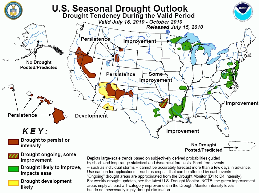
A recent heat wave coupled with below normal rainfall has resulted in drought development across the mid-Atlantic
and southern Appalachians. However, much-needed rainfall has occurred in parts of the eastern U.S. drought areas
since July 9. Although improvement is forecast for the eastern U.S. drought areas, small areas of drought could
linger. Hot, dry weather has also led to drought development for the lower Mississippi Valley and parts of
northern Texas. Improvement is forecast by the end October, but no relief is expected during the latter half of
July. Since the beginning of June, major drought improvement has occurred across the upper Mississippi Valley
and Great Lakes region. Improvement is likely to continue. The southwest monsoon that typically peaks during
August has started weakly. Most tools on the monthly and seasonal time scales indicate a tilt in the odds for
below median rainfall. Therefore, persistence or development is forecast for Arizona and New Mexico. A dry
climatology favors drought persistence across western Wyoming, northeast California, Nevada, and the leeward
sides of the Hawaiian Islands.
|
|
Tools used in the U.S. Drought Outlook (USDO)
included the official CPC precipitation outlook for August 2010 and the long lead forecast for
August - October 2010, various medium- and short-range forecasts and
models such as the 6-10 day and 8-14 day forecasts, the soil moisture
tools based on the GFS model and the Constructed Analogue on Soil (CAS) moisture, the Climate Forecast
System (CFS) seasonal precipitation forecasts, climatology, and initial conditions.
During the past month, substantial
drought relief has occurred across the upper Mississippi Valley and Great Lakes region where extreme
drought (D3 according to the USDM) has been reduced to moderate (D1)– severe drought (D2) levels. The 1-5
day precipitation forecasts indicate the potential for several inches of rainfall. In addition, the 6-10/8-14
day forecasts indicate enhanced odds for above median rainfall. In the longer ranges, such as the 30- and
90-day periods, the odds favor neither abnormally wet nor dry conditions. Improvement is forecast in this
region, but some lakes and reservoir levels may remain below normal.
Forecast confidence for the upper Mississippi Valley and Great Lakes region is high.
Hot temperatures combined with a
lack of rainfall have resulted in the development of extreme drought (D3) in northern Louisiana, severe
drought (D2) in parts of Texas, and moderate drought (D1) in southeast Missouri. Rainfall associated with
Hurricane Alex remained mostly outside of the aforementioned drought areas. From January 1 – July 13, the
rainfall deficit has increased to nearly 10 inches at Shreveport, Louisiana. During the next 2 weeks, above
normal temperatures and mostly dry weather are expected to result in drought persistence or slight expansion.
The CPC August outlook indicates enhanced odds for above median precipitation across the Texas and Louisiana
drought areas. 9 composite cases when El Nino transitioned to La Niña indicate increased chances for above
median rainfall across much of Texas. Although drought improvement is forecast by the end of October, it
should be noted that drought is expected to persist or intensify during the next two weeks.
Forecast confidence for the lower Mississippi Valley, southeast Missouri, southeast Oklahoma, and Texas
is moderate.
Record heat and irregular rainfall
have led to rapid development of moderate drought (D1) or abnormal dryness (D0) across the mid-Atlantic and
southern Appalachians. Many areas have received only 25 – 75% of normal rainfall during the past 30 days. In
addition, numerous daily record highs were established as triple digit heat affected the mid-Atlantic. Soil
moisture levels are currently in the lowest 10th percentile across the Virginia Piedmont and southern
Appalachians. During the past week, a more favorable pattern for needed rainfall has occurred in many areas
of the mid-Atlantic. For example, the July rainfall total now exceeds 3 inches at Washington, DC. Additional
rainfall can be expected during the next week. However, hot temperatures may offset the beneficial rainfall.
With NOAA predicting an active tropical season, increased chances for a heavy rainfall event due to a
tropical system exists for the East Coast. Since a hydrological drought is not affecting the eastern U.S.,
drought amelioration and elimination could occur quickly with more frequent rainfall. Forecast confidence for
improvement is lowered due to 9 composites from El Niño to La Niña events indicating a tendency towards
dryness.
Forecast confidence for the mid-Atlantic and southern Appalachians is moderate.
Unseasonable wetness during the
spring resulted in removal of drought across much of the northern Rockies. Small areas of moderate drought
(D1) are depicted on the USDM in western Wyoming. A larger area of moderate drought (D1) exists in northeast
California and Nevada. A dry climatology favors persistence in these areas.
Forecast confidence for western Wyoming, northeast California, and Nevada is high.
In the Southwest, very little rain
has fallen over the moderate (D1) to severe (D2) drought areas of Arizona and New Mexico. Through mid-July,
the summer monsoon has started fairly weak. The monsoon typically peaks during August. With the CPC outlooks
for August and August-October indicating a tilt in the odds for below median precipitation, persistence or
development is forecast. If the monsoon remains erratic during the next few weeks, development may be
expanded on the updated outlook scheduled for August 5.
Forecast confidence for the Southwest is high.
Moderate to exceptional drought
(D1 to D4 designations) continues across the leeward sides of the Hawaiian Islands. Forecasts for these areas
call for below median rainfall during August - October, leading to drought persistence. A relatively dry
climatology also supports persistence. Beyond this time period, expected wetness associated with La Niña
conditions may bring improvement during the 2010-11 winter season.
Forecast confidence for Hawaii is high.
|


