|
Latest Seasonal Assessment -
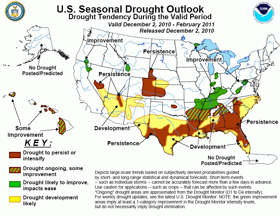
Over the past few weeks, drought continued to increase in coverage and intensity across the southern and central Plains,and parts
of the southeast. Meanwhile, due to recent precipitation, drought conditions have improved across the Ohio Valley and the central
Appalachians. Drought persistence and broad expansion is expected from central and southern Texas eastward along and near the
Gulf Coast through the southern Atlantic Seaboard. Chances for drought improvement increase away from the coastal plains, with
some improvement forecast across southern Arkansas, western North Carolina and northern parts of Alabama, Georgia and Mississippi
and with improvement anticipated for a large part of the Ohio Valley. Drought is projected to persist in the central and southern
Plains, with drought expanding into parts of south-central Nebraska and northwestern Kansas. Due mainly to climate anomalies
associated with moderate to strong wintertime La Niña episodes, drought is expected to persist and/or expand from the southern
Rockies, central Great Basin into central Nevada, and continue to improve in the Pacific Northwest and the northern Rockies. Some
improvement is indicated for Hawaii as conditions are expected to become more favorable for precipitation during the winter
months. However, with protracted drought affecting much of the western sides of the islands, improvement does not appear likely.
|
|
Tools used in the U.S. Drought Outlook (USDO)
included the official CPC precipitation outlook for December 2010 and the long lead forecast for December 2010 -
February 2011, various medium- and short-range forecasts and models such as the 6-10 day and 8-14 day forecasts, the
soil moisture tools based on the GFS model and the Constructed Analogue on Soil (CAS) moisture, the Climate Forecast
System (CFS) seasonal precipitation forecasts, La Niña composites for the December - February season, the four-month
Palmer drought termination and amelioration probabilities, climatology, and initial conditions.
Despite improvement of severe drought conditions in
eastern West Virginia during the past several weeks, two areas of moderate drought remain. A significant amount of rain has
fallen on December 1, and a modest amount of precipitation is expected over the next five days. The latest December
precipitation outlook also shows a slight tilt in the odds toward above-median precipitation. Neither dryness nor wetness is
favored over the entire season in this region, based on La Niña composites and the official December 2010 - February 2011
Seasonal Outlook. The 6-10 and 8-14 day outlooks, however, favor dryness in eastern West Virginia. Improvement is indicated
in this area based on the favorable monthly forecast and the short-term precipitation. However, overall confidence is low due
to the equal-chances seasonal forecast and the 6-10 and 8-14 day outlooks favoring dryness.
Forecast confidence for West Virginia is low.
Many areas in the southeastern U.S. are currently
in drought or abnormal dryness. In parts of the region, drought conditions began from anomalously warm and dry conditions
experienced during the summer months. La Niña composites as well as the December 2010 - February 2011 Seasonal Outlook favor
dryness for the Gulf Coast states and the Carolinas. The December outlook shows a large coverage of equal-chances for above
or below-median precipitation, though a slight tilt in the odds toward dryness is indicated along the immediate Gulf Coast.
In addition, the 6-10 and 8-14 day outlooks also generally indicate enhanced chances for below-median precipitation for most
of the southeast, and only light precipitation amounts are expected over the next five days. Thus, drought is likely to
persist or develop for most of the Carolinas and across the central and southern Gulf Coast states. Across southern Arkansas,
western North Carolina and northern parts of Mississippi, Alabama, and Georgia, a forecast of some improvement is indicated
as the seasonal forecast for these areas generally shows a slight tilt in the odds towards above-median precipitation or
equal chances for above or below-median precipitation.
Forecast confidence for most of the south-central and southeastern states is high; however, confidence is moderate in
areas where drought development and some improvement is indicated.
Drought conditions have increased in both coverage
and intensity across parts of central and southeastern Texas. The 6-10 & 8-14 day, December and December - February seasonal
outlooks all show enhanced chances for below-median precipitation for this region, though equal chances for above or
below-median precipitation is indicated for eastern Texas on the December outlook. Short-term forecasts also indicate little
to no precipitation for Texas. Drought persistence is indicated in areas where at least moderate drought exists, and drought
is likely to develop in areas where abnormal dryness is present.
Forecast confidence for Texas is high.
Drought conditions in northern parts of the Ohio
River Valley have improved significantly over the past week due to recent rains, especially in parts of Indiana. At least
moderate drought continues in northern Indiana and from southern Indiana southwestward to northeastern Arkansas. La Niña
composites for the DJF season are typically quite wet for much of the Ohio Valley area. This is also reflected in the
seasonal precipitation forecast indicating enhanced chances for above-median precipitation. Despite the 6-10 and 8-14 day
forecasts favoring dryness, drought improvement is forecast for the Ohio Valley. While drought conditions are likely to
improve in this region, it does not necessarily mean that drought conditions may be completely eliminated. This is especially
true in the bootheel of Missouri and northeastern Arkansas, where severe to extreme drought currently exists.
Forecast confidence for the Ohio Valley is high.
A small area of moderate drought persists in
northeastern Minnesota. There is no discernable tilt of the odds toward dryness or wetness indicated for December 2010 -
February 2011. Considering an ongoing trend of increasing precipitation, and the fact that winter is the ideal time of year
for moisture replenishment in the area (frequent and extended periods of sub-freezing temperatures that allow for little
snowmelt and no evapotranspiration), drought improvement is forecast.
Forecast confidence for the upper Midwest is high.
Moderate drought has expanded to cover the Nebraska
panhandle, most of the eastern half of Colorado, and west-central Kansas, with abrnomal dryness extending into parts of
south-central Nebraska. An area of moderate drought also exists in central Oklahoma. Short and medium-range forecast tools
favor dryness for this region. The monthly and seasonal precipitation tools indicate equal chances for above- or below-median
precipitation for this area. Due to the relatively dry forecasts out through the next two weeks, the forecast calls for
drought to persist across central Oklahoma, eastern Colorado, the Nebraska panhandle and western Kansas. A small area of
drought development is also forecast for southwestern/south-central Nebraska and northwestern Kansas.
Forecast confidence for the central and southern High Plains is low.
As of December 2, drought covered part of
northeastern Arizona, and a much larger area of abnormally dry conditions extended through much of northern and western parts
of Arizona & New Mexico. Short to medium-range forecasts indicate dryness for the region. Below-normal precipitation is also
shown in the December 2010 - February 2011 Seasonal Outlook, consistent with composites of past moderate to strong La Niña
years. As a result, drought is forecast to persist in northeastern Arizona and expand to cover the rest of the areas above
now assessed as abnormally dry. Additionally, drought is expected to develop in central Arizona.
Forecast Confidence for southern sections of the Four Corners states is high.
There are only a few scattered patches of drought
lingering in the remainder of the western United States, although where there is drought, it has persisted for at least
9 months, and for more than a year in central Nevada and across southern Oregon, northeastern California, and adjacent areas.
Recent snowstorms affecting the West has resulted in an early snowpack across parts of the northern Rockies and northern
California. Wintertime La Niña conditions favor enhanced chances for above-average precipitation across the Pacific Northwest
and Intermountain West. Further south into Nevada and the central and southern Great Basin, wintertime La Niña conditions
favor dryness. A storm track across the Pacific Northwest and northern Rockies favoring continued precipitation chances is
likely to exist through the next several days. Combined with the La Niña composites and the monthly and seasonal forecasts,
improvement is anticipated for the moderate drought areas in southern Oregon and western Wyoming. Across central Nevada and
the southern Great Basin, 6-10 and 8-14 day outlooks indicating a slight tilt in the odds toward dryness combined with slight
odds toward below-median precipitation in the monthly and seasonal outlooks support a forecast of persistence for the
moderate drought area in central Nevada and a small area of drought persistence across southern Nevada.
Forecast confidence for the West is moderate to high.
Drought expanded across much of Hawaii due to the
El Niño event from mid-2009 until early 2010, and has persisted or intensified since. Rainfall normally increases during the
winter, and Hawaii receives at least somewhat enhanced precipitation more often than not during La Niña years December -
February, with better likelihoods for above-normal precipitation in the ensuing months. Given the rather modest tilt of the
odds toward above-normal December 2010 - February 2011 precipitation, and the protracted nature of the current drought, which
is classified as extreme to exceptional in some areas, only some improvement is expected by the end of the period.
Forecast confidence for Hawaii is moderate.
|


