|
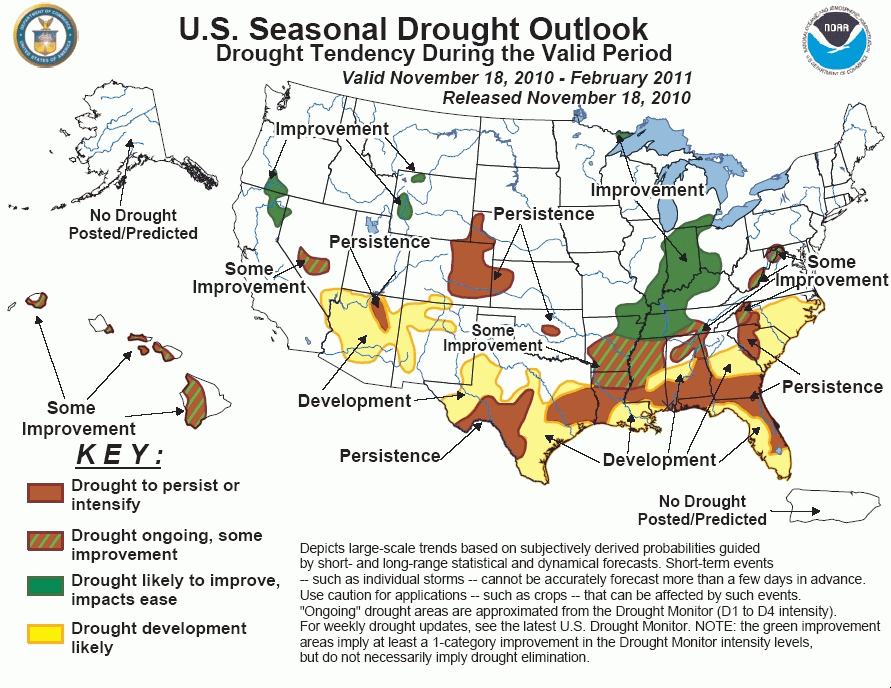
Tools used in the U.S. Drought Outlook (USDO)
included the official CPC precipitation outlook for December 2010 and the long lead forecast for
December 2010 - February 2011, various medium- and short-range forecasts and
models such as the 6-10 day and 8-14 day forecasts, the soil moisture
tools based on the GFS model and the Constructed Analogue on Soil (CAS) moisture, the Climate Forecast
System (CFS) seasonal precipitation forecasts, La Niña composites for the December - February season, the four-month
Palmer drought termination and amelioration probabilities, climatology, and initial conditions.
In the two weeks since the last Drought Outlook was
issued on November 4, severe drought was finally eradicated in the eastern West Virginia panhandle. However, two areas of
moderate drought persisted in eastern parts of the state on November 18. Little precipitation is expected through November 22,
but the 6-10 day and 8-14 day outlooks covering the period November 23 - December 1 both show odds favoring above-normal
precipitation. For the ensuing three months, neither dryness nor wetness is favored in relevant La Niña composites and the
official December 2010 - February 2011 Seasonal Outlook. As a result, some improvement is anticipated in these regions.
However, the non-committal seasonal forecast and the fact that precipitation deficits, while relatively modest, date back 6
to 12 months reduces the chances that drought will be eliminated completely by the end of February 2011.
Forecast confidence is low.
Large areas of either drought or abnormal dryness
approaching drought intensity cover a large portion of the southern and southeastern United States as of November 18, with
regions of severe drought and patches of extreme drought near the Mississippi River, portions of Alabama, southern Georgia,
and much of northern and eastern Florida. Looking at the expansive area from central and southern Texas eastward and
northeastward through central and southern Arkansas, Louisiana, Mississippi, most of Alabama and Georgia, Florida, and the
Carolinas, the outlook generally improves as one moves away from the Gulf Coast and south Atlantic Seaboard, as indicated by
a relatively consistent signal in moderate to strong La Niña composites as well as the December 2010 - February 2011 Seasonal
Outlook. In shorter time frames, less than 0.5 inch of precipitation is expected during the next 5 days regionwide, and for
the remainder of November, forecasts look similar to the Seasonal Outlook, with near- to below- normal precipitation favored
in Florida and near the Gulf and south Atlantic Coasts while heavier precipitation is more likely farther inland.
Above-normal precipitation is favored near the end of the month as far south as central Louisiana, southern non-coastal
Mississippi, and south-central sections of Alabama, Georgia, and South Carolina. However, the relatively high confidence and
agreement of the various tools for the December 2010 - February 2011 period implies that any short-term wetness slightly
removed from the coasts will not significantly influence conditions by the end of February 2011. As a result, the Drought
Outlook calls for drought to persist or expand to cover much of central and southern Texas, central and southern Louisiana,
southern and eastern Mississippi, central and southern sections of Alabama and Georgia, all of Florida, and all but the
northern and western tiers of the Carolinas. As of November 18, dryness and drought is just as extensive farther north
through northern Louisiana, central and southern Arkansas, central and northern Mississippi, northern sections of Alabama
and Georgia, southeastern Tennessee, and the northern and western tiers of the Carolinas. However, the odds for below-normal
December 2010 - February 2011 precipitation decline to the point where no particular tilt of the odds toward wetness or
dryness is evident. Therefore, some improvement is forecast for these areas, with no anticipated drought expansion.
Forecast confidence in the south-central and southeastern states is high except in areas where development is forecast
but antecedent conditions are not abnormally dry, specifically the eastern Carolinas, southernmost Florida, most of southern
Louisiana, and southeastern Texas, where confidence is moderate.
As in areas farther south, a broad area of drought
extends from northeastern Arkansas and western Tennessee northward along the middle Mississippi and lower Ohio River Valleys,
then through Indiana and southern Michigan. Since the last Drought Outlook issued November 4, drought has modestly expanded
and intensified throughout the region, but that trend is not expected to continue through the winter months. Light
precipitation at best is expected regionwide during November 18 - 22, but thereafter all tools indicate enhanced odds for
above-normal precipitation, including the 6- to 10-day and 8- to 14-day forecasts, composites of past moderate to strong La
Niña years, and the official December 2010 - February 2011 Seasonal Outlook. As a result, improvement is forecast throughout
the region by the end of the period.
Forecast confidence is high throughout this area which extends from southern sections of the middle Mississippi Valley
northeastward through the lower and middle Ohio Valley and the south-central Great Lakes region.
A small area of moderate drought persists in
northeastern Minnesota. The odds favor above-normal precipitation until the end of November, with no discernable tilt of the
odds toward dryness or wetness indicated for December 2010 - February 2011. Considering the short-term forecast, an ongoing
trend of increasing precipitation, and the fact that winter is the ideal time of year for moisture replenishment in the area
(frequent and extended periods of sub-freezing temperatures that allow for little snowmelt and no evapotranspiration),
drought improvement is forecast.
Forecast confidence for the upper Midwest is high.
Moderate drought has expanded to cover the Nebraska
panhandle, most of the eastern half of Colorado, and west-central Kansas since the last Drought Outlook issued November 4.
Light to perhaps moderate precipitation, at least somewhat above normal, is expected into late November, but odds favor
dryness during the end of the month. While the Seasonal Outlook is non-committal regarding precipitation during December
2010 - February 2011, this is a very dry time of the year climatologically, so it is unlikely, though not impossible, that
enough precipitation will fall by the end of February 2011 to substantially ameliorate the 1.5 to 3.0 inch deficits that have
accumulated since mid-August 2010. Therefore, the drought is expected to persist through this period.
Forecast confidence for the central High Plains is moderate.
As of November 18, drought covered part of
northeastern Arizona, and a much larger area of abnormally dry conditions extended through much of northern and western
Arizona, northern and western New Mexico, and adjacent sections of Nevada and Colorado. Light precipitation is forecast
during November 18 - 22 across much of these areas, with totals locally exceeding 0.5 inch in the central Arizona highlands.
Thereafter, below-normal precipitation is favored for late November and in the December 2010 - February 2011 Seasonal
Outlook, consistent with composites of past moderate to strong La Niña years. As a result, drought is forecast to persist in
northeastern Arizona and expand to cover the rest of the areas above now assessed as abnormally dry. Additionally, drought is
expected to develop in central Arizona, where winter is a slightly wetter time of year climatologically than most other
3-month periods, and where winter snowpack in the higher elevations could be substantially below normal by the end of the
period.
Forecast Confidence for southern sections of the Four Corners states is high.
There are only a few scattered patches of drought
lingering in the remainder of the western United States, although where there is drought, it has persisted for at least 9
months, and for more than a year in central Nevada and across southern Oregon, northeastern California, and adjacent areas.
Above-normal precipitation is likely in central Nevada into late November, but the Seasonal Outlook shows no tilt of the odds
toward either dryness or wetness during the winter months. Based on near-term wetness but uncertainty thereafter, some
improvement seems the forecast of least regret, without much confidence, in central Nevada. Farther north, generally 0.5 to
1.0 inch of precipitation is expected to fall on the drought areas in Wyoming and across northeastern California, southern
Oregon, and adjacent area. The odds favor above-normal precipitation in these areas during the ensuing 5 days, and the
Seasonal Outlook favors above-normal precipitation through these same areas during December 2010 - February 2011. Therefore,
improvement is expected.
Forecast confidence is low in central Nevada, and moderate to high in western Wyoming, and for the area in and adjacent
to northeastern California and south-central Oregon.
Drought expanded across much of Hawaii due to the
El Niño event from mid-2009 until early 2010, and has persisted or intensified since. Rainfall normally increases during the
winter, and Hawaii receives at least somewhat enhanced precipitation more often than not during La Niña years December -
February, with better likelihoods for above-normal precipitation in the ensuing months. Given the rather modest tilt of the
odds toward above-normal December 2010 - February 2011 precipitation, and the protracted nature of the current drought, which
is classified as extreme to exceptional in some areas, only some improvement is expected by the end of the period.
Forecast confidence for Hawaii is moderate.
|


