|
Latest Seasonal Assessment -
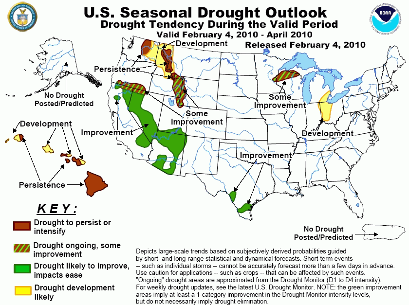
Heavy precipitation continued to slowly ease the drought in central and southern sections of the Far West during
the last half of January 2010. Record totals fell on many locations across Arizona and southern California, with
some Arizona sites receiving a typical years worth of precipitation over the course of a few days. Drought
should continue to ease in this region, with more limited relief expected farther north through southern Oregon.
To the north and east, drought in Washington and along the Idaho/Montana border is expected to persist and
expand to cover much of eastern Washington, northern Idaho, and adjacent Montana. Meanwhile, limited relief is
expected for drought areas along and near the Idaho/Wyoming border. Limited relief is also forecast for the
drought affecting part of the western Great Lakes region, primarily later in the period, but more robust relief
appears on tap for the lingering drought areas in southern Texas. Across western Ohio and adjacent parts of
Indiana and southeastern Michigan, subnormal precipitation totals have been observed for the past several weeks,
and with this pattern expected to continue through the forecast period, drought development is anticipated in
these areas. Finally, drought has expanded to cover all of Hawaii Island, and by the end of April, drought is
expected to cover the entire state.
|
|
Tools used in the Drought Outlook
included the official CPC precipitation outlook for February 2010 and the long lead forecast for
February - April 2010, the four-month Palmer drought termination and amelioration probabilities, various
medium- and short-range forecasts and models such as the 6-10 day and 8-14 day forecasts, the
soil moisture tools based on the GFS model and the Constructed Analogue on Soil (CAS) moisture, the Climate
Forecast System (CFS) seasonal precipitation forecasts, El Niño precipitation and
temperature composites for February - April 2010, climatology, and initial conditions.
Moderate to severe drought
continues in northwest Wisconsin. Medium-range forecasts call for enhanced chances of below-normal
precipitation thru mid-February, with longer-range forecasts non-committal. Based on the typical snowmelt
and increased precipitation that occurs as spring progresses, some limited improvement appears on tap for
the region by the end of April. However, since relief is expected only later in the period, uncertainty is
high.
Forecast confidence for Wisconsin is low.
Continued relief for the residual
long-term drought areas in parts of southern Texas appears likely through the late winter and early spring.
Short- and medium-range forecasts call for above-normal precipitation, and the latest monthly and seasonal
forecasts continue to indicate relatively high probabilities for wetter than median conditions during
February - April. This is consistent with typical conditions for the region during El Niño.
Forecast confidence for Texas is high.
Wetter than normal conditions are
forecast on all time scales relevant to this forecast across all but the northernmost tier of the
steadily-easing drought still covering parts of California, Nevada, Arizona, and adjacent areas. A series of
storms brought heavy to record-setting precipitation to the southern part of the area in late January 2010,
and while only moderate precipitation is anticipated in early February, outlooks for the 6-10 day, 8-14 day,
1-month, and 3-month periods all indicate enhanced chances for above-normal precipitation. Only in the
northern tier of the drought region, primarily across southern Oregon, is relief expected to be less robust.
Forecast confidence for the Southwest, Great Basin, California, and southern Oregon is high.
Drought conditions should continue
across central Washington and along the Idaho/Montana border, and are forecast to expand through the area
between these two regions in eastern Washington and much of the Idaho Panhandle. Some expansion is also
expected near the current drought area in Montana and central Idaho as well. Forecasts on all time scales
indicate at least slightly enhanced chances for below-normal precipitation through these areas, which is
consistent with typically-observed conditions during El Niño events.
Forecast confidence for Washington, northern Idaho, and western Montana is high.
Drought along and near the
Idaho/Wyoming border expanded northwestward along the Idaho/Montana border (discussed above), and reaches
southward into a small part of northern Utah. Near- to below-normal precipitation is favored in these regions
through mid-February 2010 while longer-term precipitation amounts are uncertain. Some improvement is forecast
based on some indications for at least near-normal precipitation for the period, but mid-February through
April 2010 precipitation will be critical in determining whether or not mountain snowpack ends up deficient
before snowmelt recharge begins in earnest, and the uncertain forecast for this period leads to a low
confidence drought forecast.
Forecast confidence for southeastern Idaho, western Wyoming, far southwestern Montana and northern Utah
is low.
Over much of western Ohio,
southeastern Michigan, and adjacent northeastern Indiana, short-term precipitation deficits have been
observed, below-normal precipitation is favored through mid-February, and the February - April seasonal
forecast calls for enhanced chances of below-normal precipitation. These longer-term forecasts are consistent
with conditions typically observed during El Niño events in the region. Because of antecedent normal to wet
moisture conditions, any drought development would likely take place later in the forecast period, a fact
which inherently adds uncertainty.
Forecast confidence for Ohio is moderate.
As is consistent with an ongoing
El Niño, Hawai'i is expected to receive below-median precipitation during this period. These dry conditions
will likely exacerbate ongoing areas of severe to extreme drought over Hawai'i and also provide support for
drought development over the remainder of the island chain. In early February 2010, drought expanded eastward
to cover all of the Big Island.
Forecast confidence for Hawai'i is high.
|


