|
Latest Seasonal Assessment -
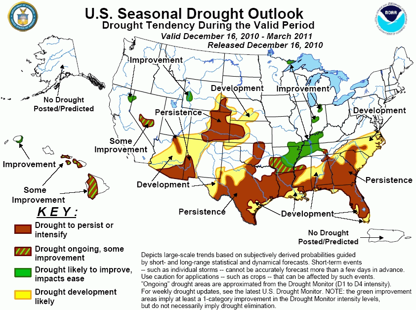
During the past several weeks, drought coverage increased or intensified across much of the Southwest, southern
Plains, and the Florida peninsula. In contrast, continued precipitation improved drought conditions across the
central Appalachians and Ohio Valley, with impacts easing across West Virginia, northern Virginia, and western
Maryland. Further west, precipitation ameliorated drought conditions in southern Oregon and northeastern
California. With moderate to strong La Niña conditions expected to continue through the northern hemisphere
winter season, strong consideration was given in this outlook to climate anomalies associated with the cold ENSO
phase. Therefore, drought expansion or intensification is expected across the Gulf Coast and southern Atlantic
states, particularly in Florida. To the north, storm systems frequently translate across the Ohio Valley region
into New England during La Niña winters, increasing the odds for drought improvement from eastern Arkansas and
western Tennessee northward into the eastern Corn Belt. A similar precipitation anomaly dipole exists across the
western U.S., with increased odds for above median precipitation in the Northwest contrasting with greater
chances of below median precipitation for the Southwest and southern Rockies. Due to this consideration,
continued improvement is expected for remaining drought areas in northern California and western Wyoming, while
drought expansion or intensification is forecasted for the desert Southwest and portions of the central and
southern High Plains. Increased odds for above median precipitation during the rainy season in Hawaii favor
improvement across the western islands, but significant improvement of long term drought conditions on the
eastern islands is more uncertain.
|
|
Tools used in the U.S. Drought Outlook (USDO)
included the official CPC precipitation outlook for January 2011 and the long lead forecast for
January - March 2011, various medium- and short-range forecasts and models such as the 6-10 day and 8-14 day forecasts, the
soil moisture tools based on the GFS model and the Constructed Analogue on Soil (CAS) moisture, the Climate Forecast
System (CFS) seasonal precipitation forecasts, La Niña composites for the December - February season, the four-month
Palmer drought termination and amelioration probabilities, climatology, and initial conditions.
Two weeks of meager rainfall were
observed across much of the deep South, with Drought conditions expanding and intensifying, particularly
across Florida, Louisiana and Texas, where most locations received below 25 percent of average rainfall.
While short term forecasts indicate the potential for rainfall exceeding 1 inch along a swath from northern
Florida through eastern North Carolina, the CPC 6-10 and 8-14 day outlooks both indicate increased odds for
below median precipitation following this period. Climate anomalies associated with La Niña strongly favor
dryness across the Southeast, particularly in Florida, and this pattern is reflected in the CPC monthly
forecast for January as well as the January-March seasonal outlook. Accordingly, widespread drought
persistence and expansion is maintained across the coastal plain and piedmont regions of the Southeast. The
forecast becomes more complicated from the southern Appalachians through far southeastern Oklahoma, as a
tight anomaly gradient exists between the Southeast and the Tennessee and Ohio Valleys, where above median
precipitation is favored. While the presence of a strong La Niña tends to expand the dry anomalies
northward, intraseasonal factors such as the Arctic Oscillation, which is currently in a negative phase, can
counteract the northward expansion of the dry anomaly. For this outlook, a boundary of some improvement
between drought persistence to the south and improvement to the north runs from southern Arkansas through
Tennessee's border with Alabama and Georgia.
Forecast confidence for the Southeast is high for the coastal plain, and low from southern Arkansas
through the southern Appalachians.
A major winter storm generated
widespread snowfall from the northern Plains through the Great Lakes region, followed by windy, bitterly cold
conditions that promoted additional lake effect snow bands. Snow depths across the small remaining drought
area of extreme northeastern Minnesota range between 10 inches and locally greater than 20 inches, with
liquid equivalents in excess of two inches. Due to the already extensive snowpack, further drought
improvement in this region is likely.
Forecast confidence for northeastern Minnesota is high.
The winter storm that brought
widespread heavy snowfall to the upper Midwest and Great Lakes region largely missed the drought areas of the
middle Mississippi Valley and Indiana. Snow depths across Indiana generally remain below 4 inches. CPC 6-10
and 8-14 day outlooks indicate enhanced odds of below average precipitation across the middle Mississippi and
lower Ohio River Valleys and equal chances across Indiana, but the monthly and seasonal outlooks both favor
enhanced above median precipitation probabilities. Storm tracks during a La Niña winter strongly favor the
Ohio Valley region, particularly during the January-March period. Based on the favorable seasonal outlook,
further drought amelioration is forecasted from northeastern Arkansas through Indiana.
Forecast confidence for the middle Mississippi and Ohio Valleys is high.
During the previous two weeks,
widespread dry weather was observed across the central and southern Plains. Drought conditions expanded or
intensified across Texas, Oklahoma, Kansas, and Colorado. Although short term forecasts indicate the passage
of two winter storms through the western U.S. during the upcoming week, very little moisture is currently
expected to pass east of the mountains. Portions of northern Texas may receive more than 0.25 inch of
precipitation, but dry weather is expected to continue across the southern half of Texas, Oklahoma, and
Kansas, with meager rainfall on the Colorado high plains. Forecasts generated from the Climate Forecast
System (CFS) indicate continued below median precipitation across the southern Plains during the
January-March period. Therefore, drought persistence is maintained, with additional development likely in
central Texas, western Kansas, and southern Nebraska, areas that are already abnormally dry.
Forecast confidence for the central and southern Plains is moderate.
Persistent dry weather across the
southwestern U.S. promoted additional drought development in southern Arizona and southwestern New Mexico
during the previous two weeks. Short range forecasts indicate the potential for two winter storms in this
region, which would bring accumulating snow to the mountains of Arizona and New Mexico that are currently
snow free. Beyond this period, however, the CPC 6-10 and 8-14 day forecasts, as well as the monthly and
seasonal forecast for January-March all predict greater odds for below median precipitation and above median
temperatures across the southern Four Corners states. Based on these forecasts, which reflect climate
anomalies observed during La Niña winters, drought persistence is maintained in this outlook, with additional
development likely throughout much of Arizona and western New Mexico.
Forecast confidence for the southwestern U.S. is moderate to high.
Above average precipitation across
southern Oregon ameliorated drought conditions, while moderate drought persisted across a small portion of
northeastern California. The recent precipitation did not spread as far inland as western Wyoming, where
drought conditions continued. Significant precipitation is likely across northern California during the
upcoming week as potent winter storms arrive onshore, with a significant amount of moisture pushing inland to
the central Rockies. The CPC 6-10 day, 8-14 day, monthly and seasonal outlooks all indicate enhanced odds of
above median precipitation throughout the northwestern U.S., favoring continued drought reduction from
northern California through western Wyoming. Although shorter range forecasts indicate enhanced
precipitation for the Great Basin as well, the seasonal forecast maintains equal chances of above, near and
below median precipitation, as the region sits between the drier Southwestern La Niña climate anomaly and the
wetter Northwestern climate anomaly. Therefore, some improvement is predicted for the Nevada drought area.
Forecast confidence for the northwestern U.S. is moderate to high.
Recent early season rainfall
improved drought conditions across the western Hawaiian islands. During a La Niña winter, climate anomalies
favor enhanced precipitation across Hawaii, but not with a high frequency of occurrence. As the rains pick
up in the January-March period, drought improvement is likely across western Hawaii, particularly Kauai, but
significant improvement is less likely across the remainder of the state, where drought conditions are more
entrenched. For the remainder of the Hawaiian islands, some improvement is indicated in this outlook.
Forecast confidence for Hawaii is moderate.
|


