|
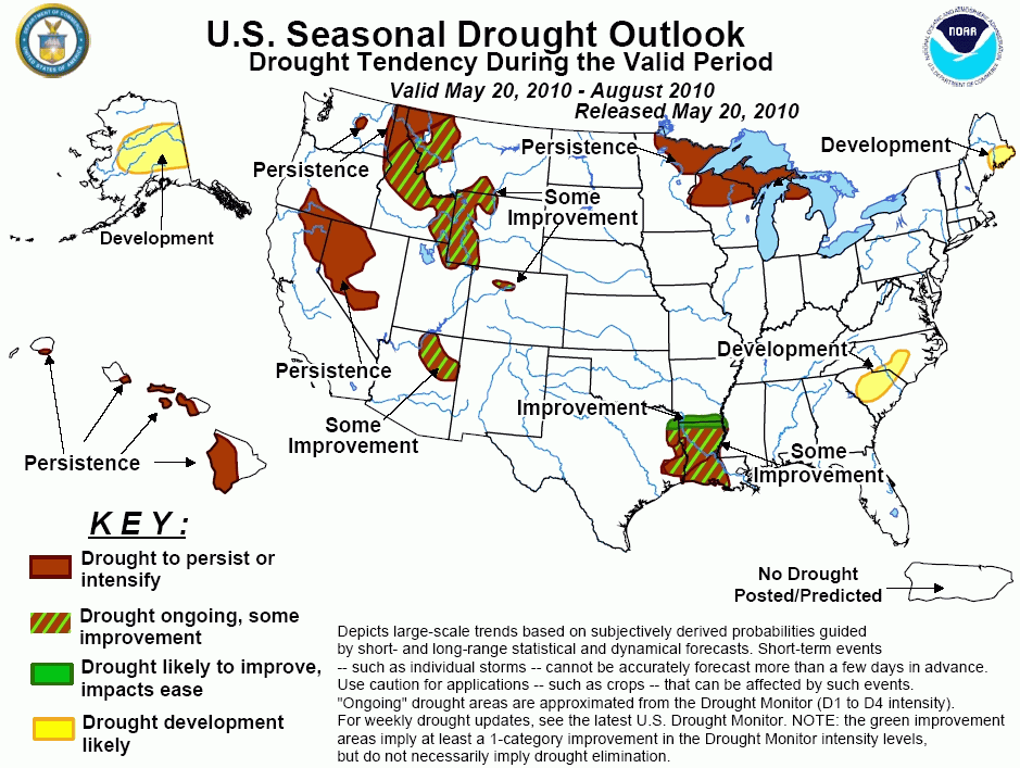
Latest Seasonal Assessment -
Continued wet weather through the end of May is expected to bring some improvement to the drought areas in western Wyoming, much
of western Montana, and central and southern Idaho. Farther northwest, however, longer-term considerations led to a forecast for
persisting drought in northwestern Montana, northern Idaho, and interior eastern Washington, where the medium range does not look
as wet and the 3-month forecast calls for enhanced chances for drier than normal conditions. To the south, drought across the
interior central West is expected to persist through the heart of the drier (and more evaporative) time of year, but late-period
monsoonal rains may bring some improvement to drought in northeastern Arizona and northern Colorado. Farther east, the protracted
drought in the northern Great Lakes region is forecast to persist despite some increased chance for wetness around the cusp of
May and June. Along the Louisiana/Arkansas border, heavy rains early in the period should lead to improvement, but with no
significant indications of dryness or wetness through most of the forecast period farther south, only some improvement is
expected in the remainder of the Louisiana and far eastern Texas drought region. Along the East Coast there is no drought to
monitor presently, but drought development is forecast for current areas of abnormal dryness, low streamflows, and reduced soil
moisture content in Downeast Maine and the parts of the interior Carolinas that missed the mid-May moderate to heavy
precipitation. The odds favor persisting drought in currently-affected areas of Hawaii, and finally in Alaska, the presence of
abnormal dryness and forecasts for a dry period through early June and warm weather for the ensuing 3 months led to a forecast
for drought development through a significant swath of the central and east-central parts of the state.
|
|
Tools used in the U.S. Drought Outlook (USDO)
included the official CPC precipitation outlook for June 2010 and the long lead forecast for
June - August 2010, various medium- and short-range forecasts and models such as the 6-10 day and 8-14 day
forecasts, the soil moisture tools based on the GFS model and the Constructed
Analogue on Soil (CAS) moisture, the Climate Forecast System (CFS) seasonal precipitation forecasts, climatology, and initial conditions.
Abnormal dryness, low soil moisture, and reduced
streamflows currently cover Downeast Maine. Some light to locally moderate rainfall is expected in the short-term, but late
May and early June look to bring a return to dry weather. Although the June - August forecast favors neither unusually wet
nor dry weather in the region, current conditions and medium-range forecasts enhance the chances for drought development.
Forecast Confidence in Downeast Maine is moderate.
In response to a recent lack of significant rain,
streamflows have become unseasonably low from parts of central North Carolina southward through central and eastern South
Carolina. Below normal rainfall is expected through late May, after which the forecasts are essentially non-committal.
However, current conditions and the lack of tangible evidence for above normal precipitation on any time scale, especially
during the summer months, have led to enhanced probabilities for drought development, although the spotty and unpredictable
nature of precipitation in this region during summer leads to a very low confidence forecast.
Forecast confidence in the Carolinas is low.
Moderate to severe drought continues in a
significant swath from northeastern Minnesota and western Wisconsin eastward across the northern Great Lakes region. In parts
of northern Wisconsin particularly, drought has become entrenched over the course of a few years. Western sections are
forecast to see some rainfall over the next couple of weeks, but amounts look to drop off farther east, and throughout the
whole region, conditions through early June should be warmer than normal, offsetting the beneficence of the rainfall at least
somewhat. In the longer ranges, the odds favor neither abnormally wet nor dry conditions, and climatology would favor some
limited improvement at this time of year. Still, given the entrenched nature of the drought in most of the region and the
lack of any indications of widespread heavy precipitation, a low-confidence forecast for drought to persist seems most
prudent.
Forecast confidence for the Upper Midwest and northern Michigan is low.
Drought continues across central and northern
Louisiana, southernmost Arkansas, and easternmost Texas. Heavy rainfall into late May should improve conditions along the
Arkansas/Louisiana border, but dryness is forecast to be more likely in the medium range, and the June - August forecast
favors neither dryness nor wetness. Given the spotty, highly convective nature of precipitation in this region during summer,
some improvement seems the forecast of least regret, though with inherently low confidence.
Forecast confidence for the lower Mississippi Valley is moderate near the Arkansas/Louisiana border, and low elsewhere.
In recent weeks, a series of winter-like storms has
moved across the western portion of the U.S., improving drought conditions from western Wyoming northward through western
Montana and, to a lesser extent, parts of Idaho. With more low pressure systems on tap for late May, additional drought
improvement is expected in the short to medium range, with the best odds centered on western Montana and central Idaho.
Despite all of these positive signs, however, this remains a difficult forecast. The areas expected to see some of the most
substantial precipitation through the end of May also have increased odds for subnormal June - August precipitation, muting
the potential for any drought relief to last through the end of the period. In sum, drought is forecast to persist across
northwestern Montana, northern Idaho, and eastern Washington where the odds for heavy precipitation through the end of May
are less than in areas to the southeast, and where the June - August forecast highlights enhanced chances of below-normal
precipitation. Farther south and east, some improvement is expected, as either the short and medium range periods highlight
the best chances for enhanced precipitation despite a summer forecast that leans dry (most of western Wyoming and central
Idaho,) or late May looks less wet, but the June - August forecast does not highlight increased odds for dryness (western
Wyoming and southern Idaho). Furthermore, the amount of improvement shown is muted based on summer climatology, which does
not favor improvement. The bottom line for this area is that the contradictory nature of the indicators leads to a low
confidence forecast throughout.
Forecast confidence for the central and northern Rockies and northern Intermountain region is low.
In northeast Arizona and northern Colorado, little
change is expected in drought conditions through June. By later in the summer, however, monsoonal moisture will begin
triggering showers and thunderstorms in these areas, and while the strength of the monsoon relative to typical years is
uncertain, climatology indicates that at least some improvement is likely.
Forecast confidence for northeast Arizona and northern Colorado is moderate.
Moderate to extreme drought continues across the
leeward side of the Hawaiian Islands. Forecasts for these areas call for below-median precipitation during the June - August
season, leading to drought persistence. Also, the islands are entering the drier time of the year, making drought
amelioration all the more difficult.
Forecast confidence for Hawaii is high.
Abnormal dryness currently exists in most of
central and interior southern Alaska. Snow water content was well below normal across this region (at or below 50% of normal).
Odds favoring below normal precipitation during the 6-14 day period combined with typically-increasing summer temperatures
and the fact that forecast odds favor warmth for the June - August period all lead to a continued and expanded forecast for
drought development for central Alaska, with somewhat increasing confidence relative to past Drought Outlook releases.
Forecast confidence for Alaska is moderate.
|


