|
Latest Seasonal Assessment -
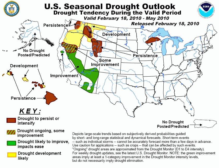
Heavy precipitation continued to slowly ease the drought in central and southern sections of the Far West during the first half
of February 2010. Drought should continue to ease in this region, with more limited relief expected farther north through
extreme southern Oregon. To the north, drought development is expected across the rest of Oregon east of the Cascades. Either
persistence of existing drought or development of new areas of drought are indicated over the northern Basin, northern half of
the Rockies, and north-central Montana. In northern Wisconsin, the long-term drought that has lasted for at least the past 18
months is likely to persist during this Outlook period. Finally, drought has expanded to cover all of the Hawaiian Islands,
and by the end of May, drought is expected to cover the entire state.
|
|
Tools used in the Drought Outlook
included the official CPC precipitation outlook for March 2010 and the long lead forecast for
March - May 2010, the four-month Palmer drought termination and amelioration probabilities, various
medium- and short-range forecasts and models such as the 6-10 day and 8-14 day forecasts, the
soil moisture tools based on the GFS model and the Constructed Analogue on Soil (CAS) moisture, the Climate
Forecast System (CFS) seasonal precipitation forecasts, El Niño precipitation and
temperature composites for March - May 2010, climatology, and initial conditions.
Moderate to severe drought continues in northwest
Wisconsin. Extended-range forecasts, as well as the 90-day forecast for MAM 2010, call for enhanced chances of below-median
precipitation, while the intermediate 30-day CPC forecast indicates equal chances (EC) of below-, near-, and above-median
precipitation. The drought in this area has lasted for at least 18 months, and any rain/snow that has fallen during this
period has not been sufficient to gain the upper hand on this situation. CFS precipitation forecasts and El Niño composites
for the M-A-M season favor persistence of dryness across this region. In the northern Ohio Valley and southern Great Lakes
region, below-median precipitation is anticipated for the extended-range period, as well as the 30-day forecast period
(March 2010), though this dry signal is expected to shift northward as the MAM season progresses. The area of developing
drought depicted on the previous Seasonal Drought Outlook was removed upon reassessment of conditions. Some dryness has been
observed over a small area in northwest Ohio, and adjoining parts of Indiana and Illinois, but maintaining drought
development over the area in general is deemed too risky.
Forecast confidence for Wisconsin and the Ohio Valley is low to moderate.
Continued relief for the residual long-term
drought areas in parts of southern Texas appears likely through the late winter and early spring. Extended-range forecasts
call for a tilt in the odds towards above-median precipitation, and the latest monthly and seasonal forecasts from CPC
continue to indicate relatively high probabilities for wetter than median conditions during March, and March-May. This is
consistent with typical conditions for the region during El Niño.
Forecast confidence for Texas is high.
Near to above-median precipitation is forecast on
all time scales relevant to the Southwestern US outlook across all but the northernmost tier of the steadily-easing drought
still covering parts of California, Nevada, Arizona, and adjacent areas. Precipitation during the past two weeks has been
below- median across northern California, and near to above-median across southern California. Only in the northern tier of
the drought region, primarily far northeastern California and southern Oregon, is relief expected to be less robust.
Forecast confidence for the Southwest, Great Basin, California, and southern Oregon is high.
In the Pacific Northwest, drought conditions
should continue across central Washington and along Idaho's borders with Montana, Wyoming, and Utah. Drought development is
expected across Oregon east of the Cascades. Water supply forecasts for this region are calling for below-average spring
stream flows due to deficient snowpack. Forecasts on all time scales relative to this Outlook indicate a tilt in the odds for
warmer and drier weather for much of the Pacific Northwest, which is consistent with typically-observed conditions during
El Niño events. This dryness is largely due to the preferred tendency of the Pacific jet stream and associated storm activity
being farther south during El Niño events, primarily over California and the Southwest.
Forecast confidence for the Northwest is moderate to high.
As is consistent with an ongoing El Niño, Hawai'i
is expected to receive below-median precipitation during this period. These dry conditions will likely exacerbate ongoing
areas of severe to extreme drought over Hawai'i and also provide support for drought development over the remainder of the
island chain.
Forecast confidence for Hawai'i is high.
|


