|
Latest Seasonal Assessment -
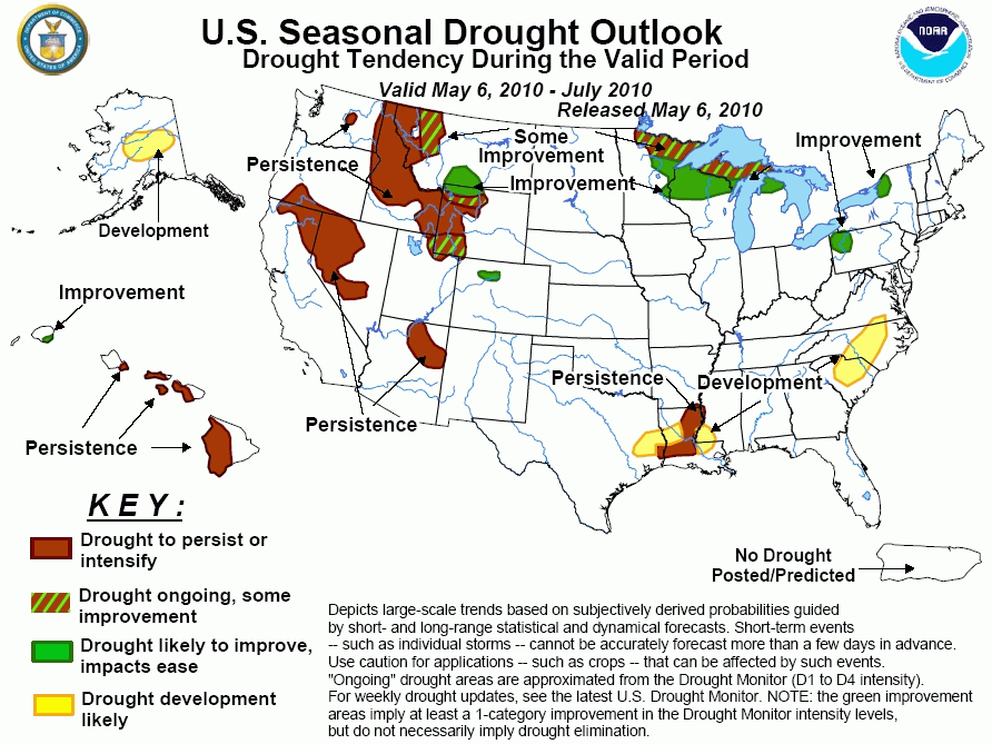
Cool, wet weather benefited dry areas in the West during April, with late-April and early-May snows significantly boosting
mountain snow pack. Rain and snow during the first half of May is forecast to bring continued moisture to the Intermountain
states and the Rockies. The updated Drought Outlook shows the odds tilting toward some improvement or better in portions of Utah,
Wyoming, Montana, and Colorado. As the West enters the drier time of the year in late spring and summer, and temperatures rise,
drought alleviation becomes more difficult, and lingering drought areas in Idaho, California, Oregon, Nevada, and Arizona are
likely to largely persist. Across the upper Midwest eastward into the eastern Great Lakes region, drought expanded as forecast
into early May, but the storm track this month favors above-normal rain across the region, resulting in likely improvement from
Minnesota to New York. The storm system that brought the catastrophic floods to middle Tennessee at the start of May erased any
prospects for drought development over the Kentucky-Tennessee area, but the heavy rains missed Louisiana and eastern Texas,
causing expansion of drought in Louisiana, and the forecast for likely expansion of drought into parts of eastern Texas and
southwestern Mississippi. The recent rains largely missed the Carolinas, and low streamflows and soil moisture along with
forecasts for warm weather and below-median rainfall into mid-May result in the likelihood for drought development over North and
South Carolina. In Hawaii, most remaining drought areas are forecast to persist as the islands enter the drier time of the year.
In central Alaska, below-average snow water equivalent values, warming June and July temperatures combined with slightly enhanced
odds for below-median precipitation support drought development in central Alaska.
|
|
Tools used in the U.S. Drought Outlook (USDO)
included the official CPC precipitation outlook for May 2010 and the long lead forecast for
May - July 2010, the four-month Palmer drought termination and amelioration probabilities, various
medium- and short-range forecasts and models such as the 6-10 day and 8-14 day forecasts, the
soil moisture tools based on the GFS model and the Constructed Analogue on Soil (CAS) moisture, the Climate Forecast
System (CFS) seasonal precipitation forecasts, climatology, and initial conditions.
Moderate to severe drought continues in northwest
Wisconsin, and moderate to severe drought has also expanded into northeastern Minnesota. These conditions are largely due to
very low streamflows, below-normal soil moisture profiles and lack of measurable precipitation in this region. The April 15
Outlook indicated development in Wisconsin and Minnesota, and this has largely taken place. Now, the short-term and
extended-range forecasts indicate above-median rainfall for this region, with the best odds for relief over the southern
portions of the drought area. As a result, the new Outlook indicates improvement across northern Wisconsin and into parts of
Minnesota. The precipitation amounts are forecast to be lower to the north, so only some improvement is depicted over the
U.P. of Michigan and farther north in Minnesota. Past years transitioning from El Nino to La Nina show a strong tendency for
below-normal rainfall in northeast Minnesota for May-July, so drought eradication appears unlikely. Although a transition to
La Nina has not been officially forecast at this time, the bulk of the dynamic seasonal forecast models now show a transition
to La Nina by early autumn, so analog years with similar developments have been considered. They played only a small role in
this Outlook, as ENSO summer impacts tend to be weak.
Forecast confidence for the Upper Midwest and northern Michigan is moderate.
Across western New York, northern Ohio, extreme
northwest Pennsylvania and eastern Michigan, well-below normal streamflows have developed despite the area picking up some
precipitation recently. Since the last Outlook, portions of the forecast development area have gone to D1 drought on the
Drought Monitor maps, specifically northwest Pennsylvania and upstate New York. Recent streamflows as of May 5 are
unseasonably low across upstate New York and into southern New England, but the 5-day QPF and CPC's 6-10 day and 8-14 day
precipitation forecasts favor above-median precipitation over the region, resulting in a more optimistic Outlook. There is a
tendency for dry conditions in the eastern Great Lakes during transitions to La Nina, so there is little confidence the
short-term relief will endure into summer.
Forecast confidence for the eastern Great lakes region is low.
The deluge that brought the historic flooding to
the Tennessee area at the start of May obviously eliminated the threat for drought development for quite some time in this
region, but the rain largely missed Louisiana and adjacent portions of Mississippi and Texas. Streamflows and current soil
moisture estimates suggest that drought could expand across Louisiana and into Texas and Mississippi very soon absent
significant rains. With warmer weather in the extended-range forecasts and some indications for low runoff and soil moisture
in seasonal forecasts, such as the Ensemble Streamflow Prediction ESP)output and ENSO transition analogs, the Outlook shows
drought expansion. Analog transition years show highly variable rainfall conditions near the coast, so development is not
extended to the Gulf. The latest extended-range forecasts suggest a wetter pattern for northeast Texas and northwestern
Louisiana, reducing development prospects in those areas.
Forecast confidence for the southern Mississippi Valley is low.
In response to recent lack of significant rains,
streamflows have become unseasonably low from parts of Virginia into central and eastern North Carolina and northern South
Carolina. The warm and dry weather forecast for the 6-10 day and 8-14 day periods suggest drought may potentially develop
quite rapidly in this area, and development is shown in this Outlook. The ESP forecasts do show elevated risk for low soil
moisture over the next 90 days in this region, but the latest GFS forecasts suggest increased rainfall later this month,
reducing the confidence in this forecast. Farther south, the transition ENSO maps suggest increased risk for dryness in the
next 3 months for Alabama and parts of Georgia, but recent heavy rains have reduced the drought risk for now.
Forecast confidence in the Carolinas is low.
In recent weeks, a series of winter-like storms
have moved across the western portion of the U.S., increasing soil moisture and mountain snow pack, especially in Utah,
Wyoming, Idaho, and Montana. With more low pressure systems on tap for the first half of May, additional drought improvement
is expected, with the best odds for southern Montana and western Montana east of the Divide, as these areas already
experienced improvement from the major late April storm that battered the region. The amount of improvement shown for the
West is muted based on the climatology going into summer, which does not favor improvement. In northern California and
southern Oregon, recent storms have boosted reservoir supplies, and the Drought Monitor may reflect improvement in future
weeks. However, the 6-10 and 8-14 day forecasts show a drier trend for the Pacific states, and climatology is unfavorable for
improvement, so the Outlook continues to indicate persistence.
Forecast confidence for the Great Basin, Rockies, and Intermountain region is moderate.
In northeast Arizona, climatology for May-June does
not favor improvement, with the next best chance for beneficial moisture during the summer thunderstorm season in July.
Persisting drought for the bulk of the 3-month forecast period is likely, so there is no change in the Outlook.
Forecast confidence for Arizona is moderate.
Moderate to exceptional drought continues across
the leeward side of the Hawaiian Islands. Forecasts for Hawaii call for below-median precipitation during the MJJ season,
leading to continued drought persistence on the leeward side of the islands. Also, the islands are entering the drier time
of the year, making drought alleviation more difficult. Recent heavy rains on the northeastern side of Kauai and continued
trade shower activity are likely to yield improvement on Kauai.
Forecast confidence for Hawaii is high.
Abnormal dryness currently exists in parts of
central Alaska. Snow water content was well below normal across this region (at or below 50% of normal). Slight odds for
below normal precipitation during the 6-10 day and 8-14 day period combined with warming temperatures later in the season
lead to a continued forecast of drought development for central Alaska.
Forecast confidence for Alaska is low.
|


