|
Tools used in the U.S. Drought Outlook (USDO)
included the official CPC precipitation outlook for November 2010 and the long lead forecast for
November 2010 - January 2011, various medium- and short-range forecasts and models such as the 6-10 day and
8-14 day forecasts, the soil moisture tools based on the GFS model and the Constructed Analogue on Soil
(CAS) moisture, the Climate Forecast System (CFS) seasonal precipitation forecasts, La Niña composites
for the September - November season, the four-month Palmer drought termination and amelioration probabilities,
climatology, and initial conditions.
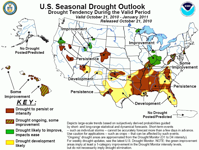
After widespread heavy late
September and early October rains produced substantial drought relief from the eastern Carolinas into New
England, additional light to moderate (and locally heavy) rains in the Northeast have erased drought in New
England and diminished dryness in the mid-Atlantic. Some dry pockets, however, remained in the central
Appalachians and southern New Jersey. In these areas where drought impacts are slightly greater, short and
medium-range forecasts suggest continued surplus rain, but the monthly and seasonal forecasts offer equal
chances for above- or below-median precipitation in the central Appalachians while the seasonal outlook tilts
slightly toward dryness along the coast. Therefore, some improvement is forecast for the mid-Atlantic due to
the less optimistic seasonal outlook and the moderate to strong La Niña years composites.
Forecast confidence for the mid-Atlantic is moderate.
Continued dryness during the past
two weeks maintained or intensified drought conditions across the remainder of the Southeast and the lower
Mississippi and Ohio Valleys. Climate anomalies observed during La Niña events favor below-median
precipitation with a high frequency of occurrence, except in the Ohio Valley where above-normal precipitation
is common during the late winter and spring season. Short and medium range forecasts and both the 6-10 and
8-14 day outlooks, however, indicate near to above-median precipitation in the Mississippi and Ohio River
Valleys and parts of the Southeast, although the November and November-January outlooks have odds tilted in
favor of below-median precipitation across the lower half of the Mississippi Valley and the Southeast.
Therefore, with ample precipitation expected in the short and medium term and in the seasonal outlook,
improvement was shown in the Ohio Valley. Elsewhere, abnormally drier conditions associated with La Niña are
expected to extend eastward, southward, and westward during the upcoming three months as tropical cyclone
activity markedly decreases during November. Therefore, drought persistence is maintained across the
Southeast in areas that have slipped into moderate drought. A large area of drought development is forecast
for most of the Southeast not currently in moderate drought, including parts of western Arkansas, eastern
Texas, the southern Appalachians, and along the Gulf Coast. The normal seasonal decrease in tropical cyclone
activity adds confidence to the forecast, along with the ongoing moderate to strong La Niña event expected to
persist into the spring.
Forecast confidence for the Southeast, Delta, and Ohio and Tennessee Valleys is moderate to high.
Much drier weather returned to the
northern Plains and upper Midwest during the previous two weeks, ending (for now) a wet pattern that
commenced this summer which nearly ameliorated all drought conditions in the region. Only a small area in
northeastern Minnesota remained in drought. The short and medium term forecasts expect light to moderate
precipitation in the short term, with CPC's 6-10 and 8-14 day outlooks favoring above-average precipitation
chances. The monthly and seasonal outlooks maintain equal chances for above, near, or below median
precipitation. Climate anomalies observed during La Niña events show a trend towards above-median
precipitation in northern Minnesota, although the frequency of occurrence is not high (near 50 percent). With
expected short and medium term surplus precipitation, an ongoing wet trend, and ideal time for moisture
replenishment (cool weather, no evapotranspiration, growing season ended), drought improvement is maintained
for the upper Midwest.
Forecast confidence for the upper Midwest is moderate.
Soil moisture that was plentiful
across much of the southern Great Plains following the early September passage of Tropical Storm Hermine has
dwindled as much drier weather has occurred the past 45 days. An exception to this has been extreme southern
Texas where ample mid- to late September rains have maintained wetness. With the exception of heavy rains
during the next 5-days (from HPC) in northern Texas and Oklahoma, all forecasts from the short to medium
range through the seasonal outlook indicate enhanced chances of below-median precipitation and above-normal
temperatures. And with the likelihood of little or no "bonus" tropical cyclone rains (such as from Hermine)
in the western Gulf Coast due to decreased tropical cyclone formation and southward-displaced mid-latitude
troughs that tend to recurve any tropical cyclones eastward away from the region, drought persistence is
maintained in Oklahoma and northern and southwestern Texas. In addition, development was extended across most
of south-central Texas, northern Texas and Oklahoma, and parts of eastern New Mexico where La Niña conditions
are strongly associated with decreased precipitation and increased temperatures.
Forecast confidence for the southern Plains is moderate to high.
Abnormal dryness has increased
throughout much of eastern Colorado, western Nebraska, and eastern Wyoming as moderate drought has expanded
from northeastern Colorado into western Nebraska. Short-term forecasts show light to moderate precipitiation
in this region, while CPC's 6-10 and Week-2 outlooks portend above-normal precipitation. The monthly and
seasonal outlooks, however, show no odds toward either above- or below-median precipitation, although both
outlooks favor above-normal temperatures. The La Niña composites for NDJ period show a slight tendency for
below-normal precipitation in the central Great Plains and above-normal precipitation in the central Rockies.
Thus, without any strong indicators for improvement or deterioration in the central High Plains, drought is
maintained.
Forecast confidence for the central High Plains is low to moderate.
The 2010-11 Water Year got off to a
wet start in the Sierra Nevadas and Great Basin as unseasonably heavy early October precipitation (and severe
weather) was produced by a strong upper-air low that tracked northwestward from the Southwest. There was
enough precipitation to diminished drought and abnormal dryness in this region. As winter approaches, the
atmospheric response to La Niña shifts the favored Pacific storm track northwestward, bringing increased
precipitation to the Northwest. Accordingly, La Niña NDJ composites show above-median precipitation across
the Pacific Northwest and into the northern Rockies, with an abrupt transition to subnormal precipitation in
central California (albeit a weak signal). The CPC monthly and seasonal outlooks indicate enhanced chances of
above-median precipitation extending from the Pacific Northwest eastward into Wyoming. Therefore, drought
improvement is forecast for southern Oregon, extreme northern California, western Wyoming, and northern Utah;
some improvement is indicated across northeastern California (transition area); and drought persistence is
forecast for the northern Sierra Nevadas and south-central and northern Nevada.
Forecast Confidence for the Northwest and Great Basin is moderate to high.
The same upper-air low that soaked
the Sierra Nevadas and Great Basin in early October first impacted the Southwest with severe weather
(tornadoes) and unseasonably heavy rains. Hardest hit was northern Arizona where several tornadoes produced
damaged west of Flagstaff. Two to as much as six inches of rain fell on northern Arizona, southern Utah, and
California's Sierra Nevada, with 1 to 2 inches of rain over most of Nevada. The early season bonus rains were
enough to diminish drought conditions in parts of Arizona, Nevada, Utah, and California. The short-term
forecast calls for scattered showers and thunderstorms, some locally heavy, while CPC's 6-10 day and Week-2
outlooks have equal-chances (no odds) for precipitation. Further out, the monthly and seasonal outlooks
depict enhanced chances for dry conditions, and La Niña NDJ composites also favor dryness and warmth in the
Southwest, especially in eastern areas. Some slight improvement to conditions is possible in Arizona in the
short-term, but more significant improvement is not likely given the increasingly dry long-range forecasts.
Drought persistence is indicated for the rest of the Southwest drought area, with development in northeastern
Arizona and northern New Mexico where the early October rains missed and soil moisture (NLDAS) is much
lower.
Forecast confidence for the Southwest is moderate.
Drought expanded across much of
Hawaii due to the El Niño event from mid-2009 until early 2010, and has persisted or intensified since. Since
rainfall normally increases during the winter, and Hawaii typically receives enhanced precipitation during a
La Niña northern hemisphere winter season, one would expect favorable odds for above-normal rainfall.
However, this La Niña effect primarily occurs after the forecast range of this seasonal outlook (DJF through
MAM). Additionally, not all La Niña events equate to wetter than normal conditions. During the 1999 and 2000
La Niñas, the leeward sides recorded subnormal rainfall, resulting in a 4-year drought (1998-2001).
Therefore, with this uncertainty and being just outside the La Niña "wet" time frame, some improvement is
possible, especially along the windward sides of the islands.
Forecast confidence for Hawaii is moderate.
|


