|
Latest Seasonal Assessment -
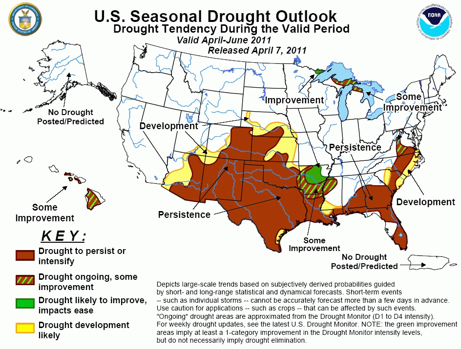
The seasonal drought outlook for April-June 2011 is based in part on stream flows, soil moisture
conditions, observed precipitation anomalies, mountainous snow water content, the CAS soil moisture outlook, and the CPC monthly
and seasonal temperature and precipitation outlooks. Precipitation has been above-normal for the past few weeks from New England
southwestward across the Appalachians to the central Gulf Coast states, as well as over central Florida, bringing significant
drought relief to some areas. West-central Florida in particular received up to 9 inches (225 mm) of rain during what is normally
considered the height of their dry season. In contrast, Arkansas, most of Louisiana, and the southern half of the Great Plains
region has received less precipitation than usual, resulting in further deterioration of drought, especially around the Ark-La-Tex
area. For the April-June forecast period, it is unlikely for the region to experience much relief from the continuing and
intensifying drought. In the Southwest, April-June is considered the dry season, and little relief is anticipated until the
climatological onset of the summer monsoon. In Hawaii, after a wet La Niña winter for much of the Islands, the typical trade wind
pattern is likely to return, with precipitation being confined mainly to windward slopes.
|
|
Tools used in the U.S. Drought Outlook (USDO)
included the official CPC precipitation outlook for April 2011
and the long lead forecast for April - June 2011, various medium- and short-range forecasts and
models such as the 6-10 day and 8-14 day forecasts, the soil moisture
tools based on the GFS model and the Constructed Analogue on Soil (CAS) moisture, the Climate Forecast
System (CFS) seasonal precipitation forecasts, La Niña composites for the April - June season, the four-month
Palmer drought termination and amelioration probabilities, climatology, and initial conditions.
During the past 30 days, precipitation
deficits (up to 75 mm) over the southern Atlantic Coastal Plain have been largely offset by
moderate to heavy rain (25-50 mm) that fell in the past week. Stream flows in the region have been boosted to near-normal values.
Surplus rainfall (75-225 mm) in west-central Florida during the past few weeks has also led to a significant boost in river and stream
flows, with some gauges reporting flow values that are much above normal for this time of year (at or above the 90th percentile). The
anticipated drought development area over Florida that was shown on the previous Drought Outlook (released March 17th) has therefore
been removed. Heavy rainfall over much of Georgia, Alabama, and Mississippi warrants the removal of drought development for those areas.
In contrast, much below normal stream flows (lowest ten percent of the historical distribution) are indicated by a few USGS gauges
across the Piedmont region of North Carolina, much of south-central Virginia, and parts of northern Florida. Across the central Gulf
Coast region, surplus rainfall (up to 150 mm) was reported during the past 30 days over northern and central Alabama, central
Mississippi, and adjacent parts of far eastern Louisiana, while other areas generally received subnormal rainfall (deficits up to 75
mm). In areas which received surplus rainfall, there was corresponding replenishment (back to normal or even above normal) of river
and stream flows. The updated CPC 30-day outlook for April 2011 calls for enhanced odds of below-median rainfall over Florida and
extreme southern parts of Alabama, equal chances (EC) of below, near, and above-median rainfall across the remainder of Alabama,
Georgia and the Carolinas, and enhanced chances of above-median rainfall over the mid-Atlantic region. Odds for below normal
temperatures are enhanced over the mid-Atlantic region, while EC is predicted over the Southeast. The official CPC 90-day precipitation
outlook for AMJ 2011 calls for EC over the middle Atlantic region and most of the Southeast, with the exception of the Florida
peninsula and extreme southern Alabama, where there are slightly elevated odds of deficit rainfall. Odds for above normal temperatures
are slightly elevated over South Carolina, Georgia, Alabama and Florida, with EC anticipated from North Carolina northward. The
Constructed Analog Soil moisture (CAS) tool predicts by the end of June that soil moisture values will range from near-normal in
northern portions of Georgia - Alabama - and Mississippi, to deficits of 60 mm near the Gulf Coast.
Forecast confidence for the middle Atlantic States is low to moderate.
Forecast confidence for the Southeast is moderate.
In the lower Mississippi Valley, conditions range
from abnormally dry (D0) to extreme drought (D3). The hardest hit areas include
western Louisiana and southern Arkansas, where CPC's soil moisture ranking percentiles fall within the lowest 5 percent of the
historical distribution. NLDAS soil moisture anomalies for the top 1-meter of soil during the past week depict deficits of at least
125 mm. On the other hand, in the Ohio and Tennessee Valleys, abundant precipitation in recent weeks has virtually eliminated all
drought, with the exception of two small residual areas of abnormal dryness (D0) indicated over parts of northern Indiana and extreme
northwestern Ohio, and extreme southwestern Tennessee. The updated 30-day outlook calls for enhanced chances of above-normal
temperatures for most of the lower Mississippi Valley, EC for the Tennessee Valley, and enhanced chances of below-normal temperatures
over most of the Ohio Valley. Enhanced odds of above-median precipitation are expected for the Ohio and Tennessee Valleys, with a
slight tilt in the odds for below-median precipitation over central and southern Louisiana. For the April-June season, abnormal warmth
is the best bet for most of the lower Mississippi Valley, with EC anticipated elsewhere. For precipitation, most areas are predicted
to have equal chances (EC) for each of the three terciles, with the exception of elevated odds of abnormal dryness over Louisiana and
southern Mississippi.
Forecast confidence for the Ohio and Tennessee Valleys is moderate;
Forecast confidence for the lower Mississippi Valley is moderate.
With drier and warmer weather prevailing across Texas in recent weeks, conditions continue to deteriorate. With the exception of a
small area of abnormal dryness (D0) along the lower Texas coast, the rest of the state now has moderate (D1) or worse drought. Soil
moisture is well below average (125-160 mm) over much of eastern Texas, with less serious deficits elsewhere across the state, while
the Vegetation Drought Response Index (VegDRI) is consistent with severe to exceptional drought (D2-D4) conditions in and around the
Ark-La-Tex region. The eastern third of Texas is reporting much below normal stream flows (lowest 10 percent of the historical
distribution for this time of year). Unfortunately, the CPC 30-day and 90-day outlooks, as well as the CAS soil moisture outlook
through the end of June, forecast the continuation and the intensification of anomalously warm and dry conditions for most of Texas.
The northern third of the state can expect some frontal activity (and potentially limited relief) throughout the spring, while
southern sections are climatologically vulnerable to tropical storms and hurricanes, most notably in June. Of course, tropical rains
for southern and eastern Texas in June are not guaranteed, just more likely.
Forecast confidence for Texas is high.
For the south-central Plains, as with Texas, conditions continue to deteriorate. During the past 3 months, observed precipitation was
near-normal across eastern Colorado, though deficits of 30-90 mm accumulated in Kansas and south-central Nebraska, and deficits in
excess of 150 mm were noted in southeastern Oklahoma. As of April 5th, half a dozen wildfires were still in progress over this latter
region, ranging from 160 to nearly 1500 acres in size. Stream flows in the southeastern quarter of Oklahoma are generally running in
the lowest quartile, when compared to historical stream flow for this time of year. The drought over the south-central Great Plains
is unlikely to expand northward into the Dakotas, given high soil moisture values, localized and persistent flooding, and substantial
snow cover in North Dakota. The CPC 30-day temperature outlook depicts elevated odds of above-normal temperatures over the south-
central Plains, while the 90-day outlook keeps abnormal warmth only over Colorado, and far western and far southern portions of
Oklahoma. There is a slightly elevated chance of below-median precipitation across the south-central Plains during April 2011, with
EC expected during the April-June season.
Forecast confidence for the south-central Plains is moderate to high.
During the past 90-days, drier than normal conditions have affected much of Arizona and New Mexico, with precipitation deficits
generally running between 30-90 mm. Precipitation deficits and depleted soil moisture are typical of La Niña winters due to the
northward displacement of the jet stream and associated storm track. The April 6th SNOTEL report indicates basin-averaged snow water
content (SWC) is at 25 percent or lower over most of southern and central sections of both Arizona and New Mexico, though SWC values
are considerably closer to average in far north-central New Mexico. Water-Year-To-Date (WYTD) precipitation values are running between
25 and 49 percent of normal over south-central parts of Arizona and New Mexico, and between 50 and 74 percent of normal over north-
central New Mexico. Decreasing precipitation climatologies for areas already in drought strongly support CPC's AMJ 2011 outlook which
calls for enhanced chances of below-median precipitation across New Mexico, Arizona, southeastern Utah, and southwestern Colorado, and
above average surface temperatures.
Forecast confidence for the Southwest is high.
Heavy rainfall this winter has alleviated drought and dryness on Kauai and Oahu and diminished drought conditions across most of the
rest of the central and western Hawaiian Islands which is typical for a La Niña winter. For the April-June forecast period, it is
becoming less likely that the western sides of the Islands will see substantial improvement as trade winds become more dominant
heading toward the warm season.
Forecast confidence for Hawaii is high.
|


