|
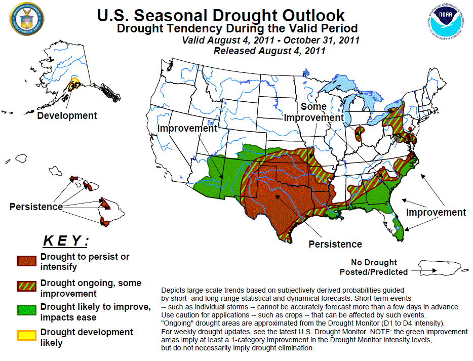
Latest Seasonal Assessment -
Climate anomalies attributed to the Summer 2010 - Spring 2011 La Niña event promoted
widespread drought development and intensification across the southern tier of the
U.S. In many locations, significant deterioration occured, with the southern Great
Plains experiencing some of the worst impacts. Apart from the relief afforded by
isolated thunderstorms, or perhaps a tropical system, drought conditions are
anticipated to persist over the south-central states through the August-October
period. During the past few weeks, a persistent ridge of high pressure maintained
hot, dry conditions across the core drought areas of the southern Great Plains.
Heavy rain (2-3 inches) fell across portions of the central and northeastern Gulf
Coast, bringing substantial relief, while daily wet-season thunderstorms throughout
the Florida Peninsula continued to erode entrenched drought conditions. For most
of the Southeast, substantial improvement is forecast for the August-October 2011
season. Additional drought improvement is anticipated across Arizona, western New
Mexico, and southern Colorado, due to a fairly healthy monsoon circulation across
the Southwest. However, eastern New Mexico and western Texas have yet to see
comparably widespread, significant rainfall, and prospects for this area remain
uncertain. Across Hawaii, leeward drought persistence is expected under the summer
trade wind regime, while developing drought is possible in Alaska's Kenai Peninsula
region.
|
|
Tools used in the U.S. Drought Outlook (USDO)
included the official CPC temperature and precipitation outlooks for August 2011
and the long lead forecast for August - October 2011, various medium- and short-range forecasts and
models such as the 6-10 day and 8-14 day forecasts, the soil moisture
tools based on the GFS model and the Constructed Analogue on Soil (CAS) moisture, the Climate Forecast
System (CFS) seasonal precipitation forecasts, the four-month Palmer drought termination and amelioration
probabilities, climatology, and initial conditions.
A persistent ridge of high pressure maintained dry conditions and much
above normal temperatures across the central U.S., exacerbating the
widespread drought entrenched across the southern Plains. Daily maximum
temperatures in San Angelo, TX have broken 100 degrees Fahrenheit 61 times
so far in 2011 (as of July 26th), and there have been 28 consecutive days
of highs reaching 100 degrees or more so far (as of July 29th), according
to the National Weather Service Office in San Angelo. Both of these events
are highly unusual. Mean temperatures for the month of July have averaged
as much as 7 degrees F above normal over much of the Red River Valley,
including much of Oklahoma and portions of north-central Texas. Isolated
thunderstorms across the region have provided little to no relief under
the persistent heat and widespread dryness. Drier weather is typical
across eastern Texas northeastward through the lower Mississippi Valley
during August, with climatological rainfall increasing slightly towards
the beginning of autumn. Climatological rainfall increases more
substantially in early autumn across southern and southwestern Texas.
Short, medium, and extended range forecasts, including the CPC 6-10 and
8-14 day outlooks all indicate enhanced chances for below-median rainfall
across the southern Plains states. The CPC August outlook maintains
elevated chances of below-median rainfall for most of the southern Great
Plains and lower Mississippi Valley. The seasonal precipitation outlook
for August-October 2011 calls for equal chances (EC) of below, near, and
above-median precipitation for this region. The Constructed Analog on Soil
moisture (CAS) outlook for the end of August and the end of October persist
the dryness across the southern Great Plains. Based on these outlooks,
continued drought persistence is likely.
Forecast confidence for the southern Plains is moderate (near the coast) to
high (well inland).
During the previous two weeks, heavy rainfall overspread portions of the
central Gulf Coast and north-central Florida, with surpluses of 2 to 3 inches
in most locations, but close to double these amounts in portions of southeastern
Louisiana, central Mississippi, and along the extreme upper Texas coast (AHPS
precipitation analysis). The heavy rainfall substantially boosted streamflows
and ameliorated the widespread exceptional drought (D4)conditions. However, the
CPC 6-10 day and 8-14 day outlooks favor elevated chances of below-median
rainfall over this area, while the 30-day outlook for August favors equal
chances (EC). The seasonal outlook for August-October tilts the odds in favor
of above-median precipitation for the eastern Gulf region, primarily due to
long-term precipitation trends. The skill-masked Climate Forecast System (CFS,
version 2) favors relatively weak and mixed signals over this region. Given the
peak of the Atlantic hurricane season falls just before the midpoint of the
outlook period, continued drought improvement is expected across the Gulf Coast.
Forecast confidence for the central and northeastern Gulf Coast is moderate.
Over the past few weeks, daily thunderstorms associated with the seabreeze-driven
rainy season, as well as a brief influx of moisture associated with a tropical
wave, helped to ease the areas of entrenched drought over the Florida Peninsula.
Keetch-Byram Drought Indices across the state remained generally between 300 and
500, indicating a diminished risk for wildfire spread. Additionally, no areas of
exceptional drought (D4) remain in the state. As the rainy season continues across
Florida, further drought reduction is likely. Tropical Storm Emily is expected to
pass just offshore of Florida's east coast shortly after the release of this
Drought Outlook, and could bring additional rainfall to the region, further easing
drought conditions. Both the CPC monthly outlook for August and the seasonal
outlook for August-October maintain enhanced chances for above-median rainfall
across much of the Florida Peninsula. Based on these considerations, and the fact
that the climatological peak of the Atlantic hurricane season falls near the
midpoint of the August-October period, drought improvement is maintained.
Forecast confidence for the Florida Peninsula is high.
Across the remainder of the Southeast, below-median rainfall was observed during
the previous two weeks across northern Mississippi, most of both Alabama and
Georgia, as well as most of the Tennessee Valley, although scattered thunderstorms
provided some local drought relief. In the Carolinas, several weak fronts stalled
across the region, accompanied by increased coverage of showers and thunderstorms.
The August-October climatology across the interior South trends slightly drier in
the late summer, with many locations receiving only 15-20 percent of their annual
rainfall during the period. The CPC August monthly outlook does not tilt the odds
in favor of above or below median precipitation across the Southeast, with the
exception of wetter-than-median rainfall expected in southern Florida, as noted
earlier. For the August-October season, above-median precipitation amounts are
forecast over much of the southern Atlantic region due to long-term precipitation
trends, also noted earlier, with equal chances elsewhere. Moisture from tropical
systems is also a possibility during the late summer and early autumn months. Based
on these factors, at least some improvement is maintained for a large portion of
the Southeast.
Forecast confidence for the Southeast is low to moderate.
In some parts of the Northeast, the North American Land Data Assimilation System
(NLDAS) shows current, top 1-meter soil moisture deficits running between 25-50 mm.
Stream flows generally rank within the lowest quartile of the historical record for
this time of year. These areas of fairly recent abnormal dryness (D0) and moderate
drought (D1) are likely to experience some improvement over the next few months
from frontal passages, organized thunderstorm clusters (MCS), and potentially
tropical systems.
Forecast confidence for the Northeast is moderate to high.
Monsoon rainfall commenced during the first half of July across portions of the
Southwest, primarily in Arizona, Utah, and Colorado. In New Mexico, however, where
drought was present across the entire state and nearly half of the state was
experiencing exceptional (D4) drought conditions through August 1st, thunderstorm
activity was more sparse. In recent weeks, the core of monsoonal moisture has been
located near the Arizona-New Mexico border in the higher terrain of the southern
Rockies, and consistently been missing eastern New Mexico and western Texas.
Extended range predictions (6-10 day and 8-14 day) favor the continuation of
monsoon rainfall along the same general path as has been observed in the past 1-2
weeks. This also favors suppressed thunderstorm activity across the eastern monsoon
region of eastern New Mexico and western Texas. The CPC monthly outlook for August
also supports enhanced odds of below-median rainfall across the eastern monsoon
region. Equal chances of below, near, and above-median rainfall are indicated in
the CPC seasonal outlook for most of the Southwest. Based on these forecasts,
continued drought improvement is forecast for Arizona, western New Mexico, and
southern Colorado, but improvement is considerably less certain across eastern
New Mexico and western Texas, where the odds seem to favor persistence of drought
conditions.
Forecast confidence for the Southwest is moderate.
In Hawaii, the summer trade wind regime, which favors dryness on the lee sides of
the islands, favors persistence of the existing drought areas in the state.
Forecast confidence for Hawaii is moderate.
Abnormal dryness has persisted across south-central Alaska for several months.
Streamflows across the Kenai Peninsula region in particular have continued to
decline. Therefore, drought development across Alaska's Kenai Peninsula is
possible during the upcoming three month period.
Forecast confidence for Alaska is low to moderate.
|


