|
Tools used in the U.S. Drought Outlook (USDO)
included the official CPC precipitation outlook for February 2011 and the long lead forecast for
February - April 2011, various medium- and short-range forecasts and
models such as the 6-10 day and 8-14 day forecasts, the soil moisture
tools based on the GFS model and the Constructed Analogue on Soil (CAS) moisture, the Climate Forecast
System (CFS) seasonal precipitation forecasts, La Niña composites for the December - February season, the four-month
Palmer drought termination and amelioration probabilities, climatology, and initial conditions.
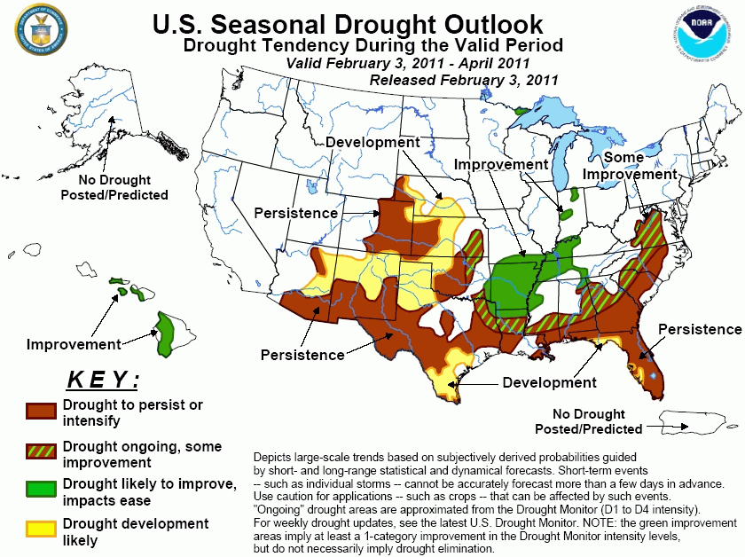
An early start to the 2010-11 dry
season combined with a lack of tropical cyclone activity during 2010 resulted in expanding drought across
Florida. 2010 rainfall departures below normal included 12.58 inches at Melbourne (3rd driest year on record)
and 14.89 inches at Vero Beach (5th driest year on record). During mid-to-late January, two periods of
rainfall prevented further worsening of drought conditions across Florida. However, river flows (according to
the USGS) in the Big Bend area and the north-central peninsula remain at or below the 25th percentile. During
early February, additional rainfall can be expected across the Florida Panhandle, while model guidance
indicates a return of mostly dry weather across the Florida peninsula. Since La Niña precipitation composites
and the CPC seasonal outlook strongly favor enhanced odds for below median precipitation, drought is expected
to persist or develop across Florida.
Forecast confidence for Florida is high.
Across the southeast U.S., La Niña
composites indicate the highest negative precipitation anomalies in southern Georgia. The CPC monthly and
seasonal outlooks indicate the highest odds for below median precipitation closer to the Gulf Coast and along
the coastal plain of the Carolinas. Therefore, drought is expected to persist across southern Georgia and the
coastal plain of the Carolinas. Due to relatively wet forecasts during the first two weeks of February and
weak signals among the precipitation tools beyond mid-February, some improvement is forecast in central
Georgia, the piedmont of the Carolinas, and Virginia.
Forecast confidence for the Southeast is moderate.
During January, northerly flow
resulted in drier than normal conditions across the lower Ohio Valley and the middle Mississippi Valley and a
slight expansion of moderate drought across northern Arkansas and southern Missouri. On February 1, a major
winter storm resulted in widespread precipitation amounts of more than 1 inch (liquid equivalent) across
these regions. The CPC monthly and seasonal outlooks favor a slight tendency for above median precipitation
across the lower Ohio Valley and Arkansas where improvement is forecast. Improvement is also forecast in
northern Louisiana, while persistence is forecast in southern Louisiana. The persistence forecast in southern
Louisiana is based on the CPC monthly and seasonal outlooks favoring below median precipitation.
Forecast confidence for the lower Ohio Valley is high and moderate for western Tennessee, Arkansas, and Louisiana.
Since January 1, near to above
normal rainfall has resulted in reduction of drought coverage and severity across the gulf coast areas of
Texas and south Texas. However, precipitation forecasts favor drier than normal conditions during February
and continuing into the early spring. Due to these relatively dry forecasts, drought is expected to persist
or return to many areas along the Texas gulf coast and south Texas.
Forecast confidence for eastern and southern Texas is moderate.
Following a drier than normal
January, heavy snow fell across parts of the central/southern plains on February 1 but missed the key drought
areas. Some improvement is forecast in northeast Oklahoma where heavy snow occurred and precipitation tools
are noncommittal during the outlook period. Otherwise, little or no change was made to the previous outlook
issued on January 20. Since the beginning of the year, severe drought has expanded in western Texas.
Precipitation tools at all time ranges indicate an elevated chance for below median precipitation in these
regions. Based upon the good agreement among precipitation tools and a relatively dry climatology, drought is
likely to persist and develop across western Nebraska, eastern Colorado, and western parts of Kansas,
Oklahoma, and Texas.
Forecast confidence for the central/southern Plains and western Texas is high.
Since mid-December, drier than
normal conditions have affected much of Arizona and New Mexico. As of February 1, river basin snow water
content values are running 25 to 75 percent of average in southeast Arizona and most of New Mexico.
Precipitation tools at all time ranges indicate enhanced odds of below median precipitation. Due to a lack of
adequate snowfall so far this winter, a tendency for dryness during a La Niña, and forecasts of below median
precipitation, drought persistence and development can be expected across much of Arizona and New Mexico.
Forecast confidence for Arizona and New Mexico is high.
During the 2010-11 winter, heavy
rainfall reduced drought conditions across the Hawaiian Islands which is typical for a La Niña winter.
Enhanced rainfall during early-to-mid February and the ongoing La Niña favor additional improvement in
Hawaii.
Forecast confidence for Hawaii is high.
|


