|
Latest Seasonal Assessment -
A classic and very persistent La Niña precipitation pattern has dominated the country since Autumn 2010, resulting
in broad areas of drought across the southern tier of states, in the southern half of the Plains, and along parts
of the lower and middle Atlantic seaboard. Extreme to exceptional drought covers most areas across the southern
Rockies, the central and southern Plains, the immediate Gulf Coast, and the southernmost Atlantic seaboard.
Drought has been most acute through Texas and the southern High Plains, where many locations experienced the
driest October through May period on record, in some places by wide margins. Frequently high wildfire danger,
dramatic agricultural impacts, and increasing hydrologic concerns have been felt throughout these areas. Farther
east, drought dates back more than a year from much of eastern Texas and Louisiana eastward through northern
Florida and southeastern Georgia even as an historic influx of water from the north flooded rivers and the
extensive marshlands in parts of Louisiana.
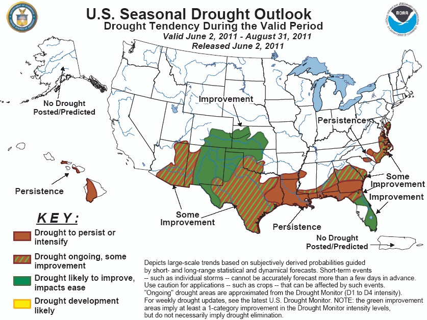
The La Niña precipitation pattern should loosen its grip through the meteorological summer of 2011, leaving a lot
of uncertainty about how drought conditions will evolve by the end of August 2011. The Drought Outlook map was
synthesized from a combination of initial drought conditions, current drought duration, forecasts for the first
two weeks of June, the June monthly forecast, and climatology (especially whether June - August is a relatively
wet or dry season) to varying degrees. Drought is expected to persist in the interior Carolinas and through much
of Louisiana and adjacent areas, where drought dates back farther than in most other areas. In other existing
areas of drought, the odds at least nominally favor some degree of improvement, though there is nothing pointing
toward anything broad-scale and substantial. To wit, the forecasts of "some improvement" and "improvement" for the
parched areas of Texas and the southern High Plains were driven by the approach of a neutral to climatologically
wet season (summer) which should provide at least some surface moistening, even if amounts aren't unusually heavy.
There is nothing to indicate that widespread, significant drought relief should be expected during the forecast
period, though that of course is a possibility; in fact, prior to any seasonal increase in rainfall across the
southern High Plains, conditions may well get worse before they get better.
|
|
Tools used in the U.S. Drought Outlook (USDO)
included the official CPC precipitation outlook for June 2011 and the long lead forecast for
June - August 2011, various medium- and short-range forecasts and
models such as the 6-10 day and 8-14 day forecasts, the soil moisture
tools based on the GFS model and the Constructed Analogue on Soil (CAS) moisture, the Climate Forecast
System (CFS) seasonal precipitation forecasts, the four-month Palmer drought termination and amelioration
probabilities, climatology, and initial conditions.
The Drought Outlook valid through
the 2011 meteorological summer (August 2011) anticipates a slow dissolution of the classic La Niña
precipitation pattern across the contiguous United States dating back approximately to October 2010. This
pattern has covered the southern tier of the country from Arizona eastward through Florida, parts of the
southern and middle Atlantic Coast, and the southern half of the Plains in drought. Extreme to exceptional
drought covers many areas from southeast Arizona and central New Mexico eastward through Florida and southern
Georgia, and much of the central and southern Plains. Precipitation has been most critically lacking in much
of Texas and the southern High Plains, where October through May totals were unprecedentedly low in many
areas.
With the unwavering La Niña pattern
expected to wane as summer 2011 progresses and the typical decline in long-lead precipitation predictability
during this time of year, there is a sharp drop in Drought Outlook confidence nationwide compared to the
forecasts issued between September 2010 and April 2011. In fact, the June - August 2011 long-lead forecast
indicates no tilt of the odds toward either above- or below-normal precipitation in any of the areas
currently experiencing drought (except in Hawaii). As a result, the June - August 2011 Drought Outlook leans
primarily on initial drought conditions, the day 1 through 14 forecasts, the June 2011 monthly forecast, and
climatology.
From southern Mississippi
northeastward into the lower mid-Atlantic coast, Light precipitation is expected through early June, and
the odds favor below-normal rainfall along the Gulf Coast through southeastern Georgia into the middle of
June. June - August is climatologically a little wetter than other times of the year along the immediate
coasts and the southeastern half of Georgia; however, drought is well entrenched in southern parts of this
region, dating back more than a year. Given these factors, drought is forecast to persist near the Gulf and
in southeast Georgia, with limited improvement expected in most other areas. Farther north, drought is also
expected to persist in the central Carolinas with some improvement anticipated farther east, where dryness
has been of shorter duration.
Confidence in the Southeast and along the eastern Gulf and southern Atlantic coasts is low.
Drought has also gripped the
Florida Panhandle to varying degrees for the past several months, which coincides with its driest time of the
year. The odds favor below-normal rainfall in northern areas through mid-June, and near- to above-normal
amounts farther south. The advent of the rainy season in June should at least alleviate any surface moisture
shortages existing at that time, even if June - August 2011 totals are unremarkable.
Confidence in the Florida Panhandle is high.
In the lower Mississippi Valley,
seriously deficient precipitation has fallen since Autumn 2010, and consistently below-normal amounts date
back well over a year through much of Louisiana even as upstream rains led to historic flooding along rivers
and across the swamps, marshes, and natural levees that cover most of southeastern Louisiana. Given the
serious, protracted rainfall deficits in place and unlikely to change substantially over the summer, drought
is expected to continue. Light to moderate rain is expected through June 6, with more than 0.5 inch forecast
near the Louisiana Gulf Coast. Odds tilt only nominally toward drier than normal conditions thereafter
through mid-June. June - August is climatologically neither a wet nor dry time of year; however, the
entrenched and long-term nature of precipitation deficits in this area will not respond readily even to
increased precipitation.
Confidence in the lower Mississippi Valley is moderate.
The southern half of the Plains
states, and in particular the southern High Plains, are experiencing the most acute drought conditions in the
country. Even though dryness dates back only to last October, the period since then has brought record
dryness to many locations, with some parts of western Texas and eastern New Mexico recording only a few
tenths of an inch during the period. Serious and intensifying sgricultural impacts and frequently high
wildfire danger has been a mainstay for several months now, and longer-term hydrologic impacts have been on
the rise. A few thents of an inch of rain is expected by June 6 across Kansas, eastern Colorado, and much of
New Mexico. Through mid-June, drier than normal conditions appear likely regionwide. Subnormal rainfall may
continue through June across Texas, but for the summer as a whole, the only indicators of which direction the
drought will take are initial conditions and climatology. The outlook for the swath of land from central
parts of Texas, Oklahoma, and Kansas westward through the southern High Plains was driven exclusively by
initial conditions and climatology. Western and northern parts of this region are headed into their wet
season as summer progresses, making it likely that at least some surface moisture improvement will be felt by
the end of August, though this forecast should not be interpreted as calling for widespread, significant
relief, and conditions may well get worse before they get better. From central Texas into south-central
Oklahoma, where June - August is not particularly wet and/or precipitation since the start of the water year
has been particularly sparse, limited improvement is expected at best, even if it is only a marginal boost in
surface moisture. Persistence is only forecast in eastern Texas, where drought dates back farther than in the
rest of the region.
Confidence in the southern half of the Plains is moderate.
Drought also covers the Southwest
from western New Mexico through central Arizona. A few tenths of an inch of rain is expected in western New
Mexico through early June, but generally drier than normal conditions are expected areawide through the
middle of the month, although this is a dry time of year for the region anyway. Later June through August
tends to be wetter climatologically, though not to the extent observed a little farther to the east. The
result of these considerations is a forecast for some improvement.
Confidence in the Southwest is low.
In Hawaii, there are enhanced
chances for drier than normal June - August conditions, resulting in drought conditions similar to or
slightly worse than at the start than at the start of June.
Confidence in Hawaii is moderate.
|


