|
Latest Seasonal Assessment -
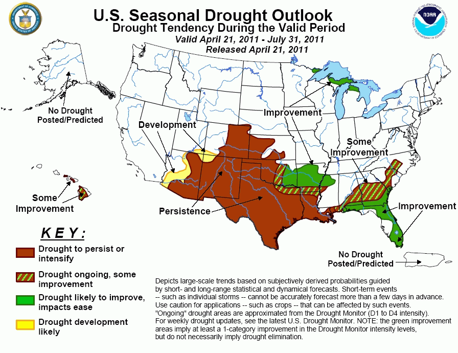
The La Niña present during the 2010-11 winter led to expansive drought development across the lower Mississippi Valley, southern
Plains, and Southwest. During the past month, drought conditions have worsened rapidly across Oklahoma, Texas, and southern New
Mexico. According to the U.S. Drought Monitor (USDM), parts of Texas are designated in the exceptional drought (D4) category.
Since the CPC monthly or seasonal outlooks favor enhanced odds for below median precipitation and above normal temperatures,
persistence can be expected in eastern Colorado, the southern high Plains, the Southwest, and much of Texas/Louisiana.
Development in parts of Arizona is related to low snow water content values and a relatively dry climatology. Prospects for
improvement increase in eastern Oklahoma and Arkansas. Across the Southeast, drought reduction has occurred since the beginning
of March. Some improvement is forecast across the interior Southeast, while odds increase for improvement across Florida due to
a wet climatology beginning in late May. It should be noted that short-term worsening of drought conditions may occur in Florida
prior to the onset of the wet season. Some improvement is forecast across the Hawaiian Islands. Outside of the drought areas
depicted on the USDM (April 21), monthly/seasonal tools offer no strong signal for dryness. This lack of a dry signal coupled
with antecedent wetness favors little or no expected development through the end of July.
|
|
Tools used in the U.S. Drought Outlook (USDO)
included the official CPC precipitation outlook for May 2011 and the long lead forecast for
May - July 2011, various medium- and short-range forecasts and
models such as the 6-10 day and 8-14 day forecasts, the soil moisture
tools based on the GFS model and the Constructed Analogue on Soil (CAS) moisture, the Climate Forecast
System (CFS) seasonal precipitation forecasts, the four-month Palmer drought termination and amelioration
probabilities, climatology, and initial conditions.
During the past 30 days, periods of rainfall
associated with frontal passages have resulted in substantial drought relief across Virginia and North Carolina. Due to the
recent wetness and no signal for below median precipitation among the tools, the drought development area over the Carolinas
that was indicated on the previous Drought Outlook (released April 7th) has been removed. The rainfall during late March and
early April has brought soil moisture and streamflow levels to near average in Virginia and northeast North Carolina. Across
the remainder of the Southeast, drought conditions have remained generally steady. Soil moisture percentiles remain at or
below the 20th percentile in parts of South Carolina and Georgia. Although no substantial drought relief is expected during
the short-term, no signal for dryness exists among the tools at the monthly or seasonal time scale. Since normal rainfall
amounts typically increase during June and July, some improvement is forecast in east-central Alabama, central Georgia, and
the small areas of drought in the Carolinas. At the end of March, heavy rain brought major drought relief to central Florida.
However, rainfall during the past 30 days was slightly below average in the Florida Panhandle and south Florida. As of April
21, levels on Lake Okeechobee are running nearly 3 feet below average. The onset of the convective rainfall season in late
May and continuing into July increases the odds for improvement later in the outlook period. Across the Florida peninsula, 30
to 45 percent of the annual precipitation occurs from May through July. In addition, June and July are typically two of the
wettest months of the year for the Sunshine State. With prospects for improvement increasing significantly with the onset of
the convective rainfall season, improvement is forecast across Florida and adjacent areas of Alabama and Georgia. It should
be noted that dry weather and hot temperatures in the short-term are expected to persist or worsen drought conditions across
Florida.
Forecast confidence for Florida is high and moderate for Alabama, Georgia, and the Carolinas.
Since the beginning of March, drought has been
eliminated in northeast Arkansas but has worsened across the remainder of the Arkansas and Louisiana. Extreme (D3) to
exceptional (D4) drought is currently depicted on the U.S. Drought Monitor in southern Arkansas and western Louisiana where
soil moisture ranking percentiles fall below the 1 percent of the historical distribution. Since the CPC outlook for MJJ
calls for enhanced odds for below median precipitation and above normal temperatures, persistence is forecast for most of
Louisiana. During the remainder of April, a very wet pattern is expected across northern and central Arkansas with model
guidance indicating the potential for several inches of rainfall. The improvement forecast for Arkansas is based largely on
this likelihood of heavy rainfall during the next week.
Forecast confidence for Arkansas and Louisiana is high.
During the past month, moderate drought (D1)
briefly expanded northeast into southern Nebraska with severe (D2) to extreme (D3) drought covering southwest Kansas and much
of Oklahoma. Despite this drought expansion, the development previously forecast (April 7) in Nebraska and Kansas is removed
due to: expected rainfall in the short- to medium-range and no signal for drier than normal conditions from May through July.
A very active pattern has become established across the Plains as an upper-level trough persists over the region. A sharp
gradient in rainfall, oriented west to east, is expected across the central and southern Plains during the final week of
April. Several inches of rainfall are possible across the eastern third of Oklahoma where improvement is forecast. Odds for
improvement diminish across the high Plains of Kansas and Oklahoma where the 8-14 day outlook along with the CPC monthly
outlook for May indicate enhanced odds for below median precipitation and above normal temperatures.
Forecast confidence for Nebraska, Kansas, and Oklahoma is moderate.
Across Texas, dry weather combined with hot
temperatures, gusty winds, and low relative humidity values has resulted in rapidly deteriorating drought conditions. As
of April 12, more than 60 percent of Texas is designated in the extreme (D3) or exceptional (D4) drought category. This is
the largest coverage of D3-D4 drought in Texas since the inception of the U.S. Drought Monitor in January 2000. Numerous,
large wildfires are ongoing across Texas. Precipitation forecasts during the next two weeks favor some improvement in
northeast Texas, close to the Red River. Persistence across south and southeast Texas is consistent with the CPC outlook for
May through July indicating enhanced odds for below median precipitation. Although persistence is forecast for central Texas,
a relatively wet climatology during May with the potential for convective outbreaks may offer small scale relief.
Forecast confidence for Texas is moderate.
Similar to Texas during a La Niña winter, drought
has also worsened across eastern Arizona, eastern Colorado, and New Mexico. Southern parts of Arizona and New Mexico are
classified as an extreme drought (D3). Basin average snow water content values are running less than 25 percent of normal
across much of Arizona. Due to the very low snow water content values, a relatively dry climatology during the outlook
period, and enhanced odds for below median precipitation with above normal temperatures, persistence and development is
forecast for Arizona. Forecast confidence is lower in eastern Colorado and New Mexico where late spring rainfall and early
monsoon moisture could bring scattered relief. Since the 6-10/8-14 day forecasts along with the CPC monthly outlook indicate
enhanced odds for below median precipitation and above normal temperatures, persistence is forecast for eastern Colorado and
New Mexico.
Forecast confidence for Arizona is high and moderate for eastern Colorado and New Mexico.
A relatively wet climatology favors improvement in
the small areas of drought in the northern Great Lakes.
Forecast confidence for northeast Minnesota and northern Michigan is moderate.
Heavy rainfall this winter ended drought on Kauai
and Oahu and diminished drought conditions across the central Hawaiian Islands which is typical for a La Niña winter. The Big
Island of Hawaii remains in moderate (D1) to extreme (D3) drought. For the May-July forecast period, it is becoming less
likely that the western sides of the Islands will see substantial improvement as trade winds become more dominant heading
toward the warm season.
Forecast confidence for Hawaii is low.
|


