|
Latest Seasonal Assessment -
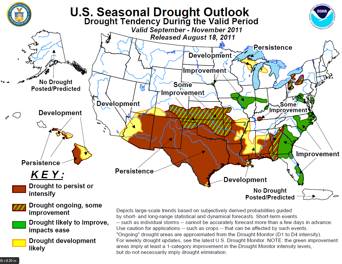
During July, while tropical Pacific oceanic anomalies indicated ENSO-neutral, the atmospheric patterns continue to reflect La
Niña-like conditions. As we progress into the Fall in the Northern Hemisphere, ENSO-neutral conditions are expected to
continue, with ENSO-neutral or La Niña equally likely thereafter. In the United States, drought attributed to the past La Niña
event (Fall 2010-Spring 2011) persisted, and in many cases intensified, in the southern Plains, especially in eastern New
Mexico, Texas, and Oklahoma. The lack of rain was accompanied by record heat, with July temperatures averaging 6 to 10 degrees
F above normal and numerous days with triple-digit highs. Even Tropical Storm Don did little to dent the drought in southern
Texas as it quickly dissipated making landfall. In contrast, drought was eased across the central and eastern Gulf Coast as
heavy thunderstorms fell there, while seasonable rains aided Florida. The Southwestern monsoon was a mixed bag, with surplus
rains falling on southeastern California, parts of Arizona, and southern Utah, but subnormal rains occurred in New Mexico and
southern Colorado. Above normal rains fell on the Pacific Northwest, and from eastern Montana southeastward to the lower Great
Lakes region. With the assumption (for this outlook) that a weak La Niña event will develop this fall (e.g. back to back La
Niña years), drought will persist or develop from the Southwest eastward into the central Gulf Coast by the end of November.
Likewise, drier conditions are predicted for the upper Great Lakes region as per the consecutive La Niña year composites. The
south-central Plains, however, were labeled some improvement due to a slight wet correlation during the second year of a La
Niña. And since much of this region is already in D4 (lower second percentile), it wouldn't take too much precipitation to
improve to D3 (lower fifth percentile). In contrast, additional drought improvement is anticipated across the southern and
middle Atlantic Coasts due to an expected above-normal Atlantic Hurricane season, CPC's September precipitation outlook, and
consecutive La Niña second year composites. Across Hawaii, leeward drought persistence is expected, with some moderate drought
development in the southern islands currently in D0 (abnormal dryness) based upon forecasted subnormal Fall precipitation from
CPC. No drought is expected/forecasted for Alaska or Puerto Rico.
|
|
Tools used in the U.S. Drought Outlook (USDO)
included the official CPC temperature and precipitation outlooks for September 2011
and the long lead forecast for September - October 2011, various medium- and short-range forecasts and
models such as the 6-10 day and 8-14 day forecasts, the soil moisture
tools based on the GFS model and the Constructed Analogue on Soil (CAS) moisture, the Climate Forecast
System (CFS) seasonal precipitation forecasts, the four-month Palmer drought termination and amelioration
probabilities, climatology, and initial conditions.
A persistent ridge of high pressure maintained hot
and dry conditions across the south-central U.S. for the second consecutive month, exacerbating the drought in the southern
Plains. According to NCDC rankings since 1895 (117 years), July was the warmest month ever in Texas and Oklahoma, while
Texas had the second driest July on record (Oklahoma ninth driest). At 3-months (MJJ), Texas and New Mexico had the second
driest such period on record (Oklahoma fourth driest), while at 6-months (February-July), New Mexico and Texas had record
dryness while Louisiana and Oklahoma were third and fourth driest. Fortunately, some relief finally arrived across central
Kansas and eastern Oklahoma during the second week of August where 3-6 inches of rain fell. Parts of central and
southwestern Texas also recorded decent (2-4 inches) rain, but it only provided minimal relief as the warmth persisted in
Texas. The Fall is typical drier across the southern Plains, although October is one of the normally wetter months in Texas
due to tropical Gulf activity and northern cold fronts dropping into the Lone Star state. The medium and extended range
forecasts indicate enhanced chances for below-median rainfall across the southern Plains states. The CPC September and Fall
outlooks maintain elevated chances of below-median rainfall for most of the southern Great Plains and lower Southwest, and
also indicate elevated odds for above-normal temperatures. And using the assumption of a La Niña developing later this fall,
the composite back to back La Niña anomalies indicate subnormal precipitation for the Southwest and western and central Gulf
Coasts, with a slight hint of wetness in the southern High Plains. However, any landfalling tropical systems in the western
Gulf during the Fall could provide relief to southeastern Texas. Based on these outlooks, continued drought persistence is
likely for the southern Plains (if no landfalling tropical systems), with a chance for some slight and spotty improvement in
parts of the southern High Plains (low confidence) and the northern edge of the drought (southern Kansas, northern Oklahoma;
moderate confidence).
Forecast confidence for the southern Plains and western Gulf Coast is low to moderate.
During July, heavy rains finally overspread
portions of the central and eastern Gulf Coast and most of Florida, providing some drought relief. The heavy rainfall
substantially boosted streamflows and greatly diminished the extreme (D3) to exceptional (D4) drought. The CPC 6-10 day and
8-14 day outlooks favor elevated chances of above-median rainfall over this area, as does the September precipitation
outlook. The seasonal outlook for September-November has no odds either way (EC). Given that the Atlantic hurricane season
peak occurs during September and that it is forecast to be above-normal (although there is no guarantee that any will make
landfall), continued drought improvement is expected across the eastern Gulf and southern Atlantic Coasts. Plus, the back to
back La Niña composites strongly show a wet fall anomaly farther north into eastern sections of the Carolinas and Virginia,
and a weaker wet signal from the Delmarva Peninsula into eastern New England.
Forecast confidence for the eastern Gulf and southern Atlantic Coasts is moderate.
Across the remainder (interior) of the Southeast,
scattered showers and thunderstorms were observed during the previous two weeks most of the interior Southeast, providing
some local drought relief. Parts of Arkansas, Mississippi, and the Carolinas were most impacted by the rains. The
September-November climatology across the interior South trends somewhat drier in the fall, with many locations receiving
only 15-20 percent of their annual rainfall (versus a normal distribution of 25 percent) during the period. The CPC
September and September-November outlooks does not tilt the odds in favor of above or below median precipitation across the
interior Southeast, except for along the eastern Gulf and southern Atlantic Coasts (wet) in the September outlook as noted
earlier. Moisture from tropical systems is also a possibility during the autumn months. However, there is a strong dry Fall
signal in composites for back to back La Niñas in the second year (from eastern Arkansas and southeastern Missouri east to
the southern Appalachians and Florida Panhandle) - IF La Niña develops this Fall. Based on these factors, persistence or
development is expected in the lower Mississippi Valley, Mississippi, and Alabama, and some improvement for Georgia
(the buffer between persistence in the west and improvement in the east).
Forecast confidence for the interior Southeast is low to moderate.
In parts of the Midwest and Northeast, heat and
spotty July rainfall quickly depleted soil moisture in the eastern Corn Belt, Pennsylvania and western New York, and the
mid-Atlantic, resulting in scattered areas of D0 and D1. During the first 2 weeks of August, however, showers and
thunderstorms became more widespread and heavier in much of this region, resulting in a reduction of D1 and D0 in the area.
An exception to this has been the upper Great Lakes region which has missed out on the beneficial rains. Accordingly, the D0
was expanded and a D1 was added this week in the U.S. Drought Monitor in the Upper Peninsula of Michigan. In addition, this
area had been suffering from long-term drought earlier this year. And based upon the consecutive La Niña composites, this
region has a strong dry anomaly for the Fall, thereby the persistence of the D1 and surrounding development. Similarly, a
weaker but distinct dry anomaly exists over interior New England, hence the some improvement (and not improvement) there.
Elsewhere, improvement is expected to continue over the next month or so from frontal passages, organized thunderstorm
clusters (MCS), and potential tropical systems, especially along the East Coast. The small area of improvement in
southeastern South Dakota (D1) is based upon the 3-month CPC precipitation outlook for increased odds of above-normal
precipitation in the north-central Great Plains.
Forecast confidence for the Midwest and Northeast is moderate.
Monsoon rainfall commenced during the first half
of July across portions of the Southwest, primarily in Arizona, Utah, and Colorado, and the monsoonal moisture traveled
northeastward into the north-central Plains and northwestern Corn Belt (Minnesota and Wisconsin). In New Mexico, however,
drought remained entrenched in the eastern half of the state, while some monsoonal showers aided the far western section. In
recent weeks, the core of monsoonal moisture has been located near the Arizona-New Mexico border and spreading slightly more
eastward into northeastern New Mexico and the Texas and Oklahoma Panhandles, but continuing to miss southeastern New Mexico
and far western Texas. Extended range predictions (6-10 day and 8-14 day) favor drier weather for the western sections of
the Southwest, and near-normal precipitation for the eastern parts. The CPC monthly and seasonal outlooks supports enhanced
odds of below-median rainfall and above-normal temperatures across the entire Southwest monsoon region. Based on these
forecasts, drought is forecast to persist from Arizona into New Mexico, with possible development in western Arizona and
southern Utah and Colorado.
Forecast confidence for the Southwest is moderate.
In Hawaii, the summer trade wind regime, which
favors dryness on the leeward sides of the islands, favors persistence of the existing drought areas in the state. This was
extended to include Lanai (currently D0 as of August 18) where drought is forecast to develop (at least D1 by end of
November). The CPC seasonal outlook also calls for subnormal rainfall for the easternmost islands (leeward and windward
sides), hence the area of developemnt on the eastern Big Island and central parts of Maui and Molokai.
Forecast confidence for Hawaii is moderate.
|


