|
Latest Seasonal Assessment -
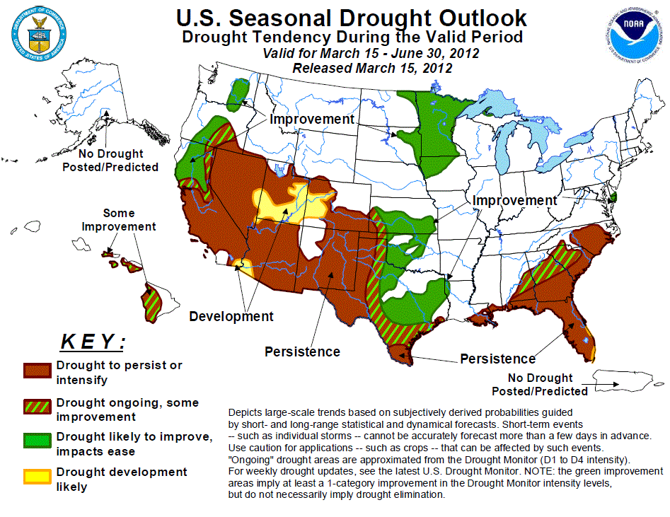
The drought outlook for March 15 – June 30, 2012 is based on short-, medium-, and long-range forecasts, initial
conditions, and climatology. Since the release of the previous drought outlook issued on March 1, 2012, drought
improvement occurred across parts of the Great Plains and along the Gulf Coast, while drought intensified across
the Florida peninsula and the West. Since the seasonal precipitation signals are weak as La Niña is forecast to
transition to ENSO-neutral conditions by the end of April, the outlook is based primarily on short to medium
range forecasts, the CPC April outlooks, and climatology. During the remainder of March, more beneficial
precipitation can be expected across the Great Plains, especially across southeast Kansas, Oklahoma, and
northern/central Texas. This March precipitation coupled with an increasingly wet climatology favor improvement
across parts of the Great Plains along with the western Corn Belt and upper Mississippi Valley. Prospects for
improvement diminish across the central/southern high Plains, while persistence is expected across the
Southwest. After an unseasonably dry winter, precipitation returned to the Pacific Northwest and California
during March. Although improvement is forecast across the Pacific Northwest and northern California due to a
favorable pattern for continued wetness throughout March, a complete recovery of the deficient snowpack in the
Sierra Nevada is not expected. Persistence is forecast for much of the Southeast due to relatively dry
conditions expected during late March and April. Late in the outlook period, improvement may begin in south
Florida with the onset of the rainy season. Some improvement is expected across the lingering drought areas in
Hawaii.
|
|
Tools used in the U.S. Drought Outlook (USDO) included the official CPC temperature and precipitation outlooks
for April 2012 and the long lead forecast for April through June 2012,
various medium- and short-range forecasts and models such as the 6-10 day and
8-14 day forecasts, the most recent 384-hour GFS total precipitation amounts, the soil moisture tools
based on the Constructed Analog on Soil (CAS) moisture, the Climate Forecast System (CFS, versions 1 and 2), the
four-month Palmer drought termination and amelioration probabilities, climatology, and initial conditions.
Since the La Niña event of 2010-2011, widespread moderate to extreme drought remains entrenched across parts of
the Southeast. La Niña conditions returned during fall 2011 but are expected to transition to ENSO-neutral
conditions by the end of April. Since mid-February, heavy rainfall (5 to 10 inches) alleviated drought
conditions along the central Gulf Coast and the Florida Panhandle. Meanwhile, the Florida peninsula experienced
near to below normal rainfall during the past 30 days. The average water level at Lake Okeechobee has fallen to
12.84 feet (down from 13.14 feet two weeks ago), and is 1.69 feet below normal as of March 14th (South Florida
Water Management District, www.sfwmd.gov). Since below median precipitation is favored during the remainder of
March and continuing into April, persistence is favored across Florida. Although the onset of the convective
season during late May and June could ameliorate drought conditions, widespread improvement is more likely
beyond the outlook period. Meanwhile, across southern Georgia and the coastal plain of the Carolinas, the odds
also favor relatively dry conditions during late March and April. Therefore, persistence is also expected across
these areas. Prospects for improvement increase across central Georgia and the piedmont of South Carolina due to
a weakening dry signal during April.
Forecast confidence for the Southeast is moderate.
Periodic precipitation during the past month reduced drought coverage and severity across the central and
southern Great Plains. According to the Oklahoma Mesonet, precipitation amounts have generally averaged between
1 to 4 inches across Oklahoma excluding the Oklahoma Panhandle. Although parts of northern and central Oklahoma
are drought-free, much of the southern Great Plains continues to suffer from the protracted drought. As an
upper-level trough progresses from the western conus, another round of beneficial rainfall is expected across
the central/southern Great Plains during latter half of March. Due to elevated odds for above median
precipitation forecast during the day 6-10 period and a relatively wet climatology during the outlook period,
improvement can be expected across parts of the central/southern Great Plains. However, across the
central/southern high Plains and south Texas, prospects for improvement are less likely as the CPC April outlook
favors below median precipitation and above normal temperatures.
Forecast confidence for the central and southern Great Plains is moderate.
As of March 13, Snow Water Content values (since Oct 1, 2011) are running 75 to 130 percent of average across
southwest Colorado and New Mexico, 60 to 80 percent of average across Utah, and 30 to 50 percent of average in
Arizona. Despite expected rain and mountain snow during the next week, initial conditions combined with an
increasingly dry climatology and enhanced odds for below median precipitation during April (per the CPC monthly
outlook), persistence or development is forecast across the Southwest. Due to the upcoming precipitation in mid
to late March, development is limited to areas currently designated as abnormally dry (southern Utah and
west-central Colorado) according to the U.S. Drought Monitor as of March 13. Although not currently depicted, an
early onset of the monsoon could bring some improvement to parts of the Southwest at the end of the outlook
period.
Forecast confidence for the Southwest is moderate to high.
An erratic seasonal precipitation pattern resulted in expansion of moderate to severe drought across the Pacific
Northwest, California, and the Great Basin during the 2011-12 winter. As of March 13, Snow Water Content values
are running 50-90 percent of average in the Oregon Cascades and less than 40 percent of average across the
Sierra Nevada of California. Precipitation deficits from February 12 – March 12 are more than 6 inches across
parts of northern California. After a prolonged dry period, precipitation has recently returned to the Pacific
Northwest and northern California. From March 14-18, HPC’s 5-day precipitation graphic indicates 4 to 8 inches
(liquid equivalent) across the Oregon Cascades south to the Sierra Nevada of California. The CPC 6-10/8-14 day
outlooks favor above median precipitation across this Pacific Northwest and northern California due to a
persistent, upper-level trough. Due to the expected wetness during the remainder of March, improvement is
forecast across the Pacific Northwest and northern California. Farther south across the remainder of California,
prospects for widespread precipitation during March diminish. In addition, an increasingly dry climatology
favors persistence across the southern half of California. Persistence is also forecast for the northern Great
Basin due to initial conditions and weaker signals for wetness during the remainder of March.
Forecast confidence for California and Oregon Cascades is moderate and low for the northern Great Basin and Washington.
Drought coverage and intensity has remained nearly steady across the western Corn Belt and upper Mississippi
Valley during the past month. A lack of adequate snowfall this winter contributes to short-term moderate to
severe drought. An approaching upper-level trough is expected to bring widespread precipitation to this region
during late March. Recent operational model runs indicate 0.5 to 2.0 inches of precipitation. Since the AMJ 2012
seasonal outlook calls for Equal Chances (EC) of below-, near-, and above-median precipitation, improvement
across the western Corn Belt and upper Mississippi Valley is based on expected precipitation during late March
and an increasingly wet climatology during the late spring.
Forecast confidence for the western Corn Belt and upper Midwest is moderate.
During early March, heavy to excessive rainfall affected the Hawaiian Islands. Lihue recorded more than 17
inches of rainfall since March 1, while more than 5 inches of rainfall recorded at Honolulu resulted in a
precipitation surplus for 2012. According to the U.S. Drought Monitor on March 13, drought is confined to: the
Big Island, Lanai, Maui, and Molokai. More typical trade winds showers resumed this week and some improvement is
forecast for any lingering drought areas.
Forecast confidence for Hawaii is moderate.
|


