|
Latest Seasonal Assessment -
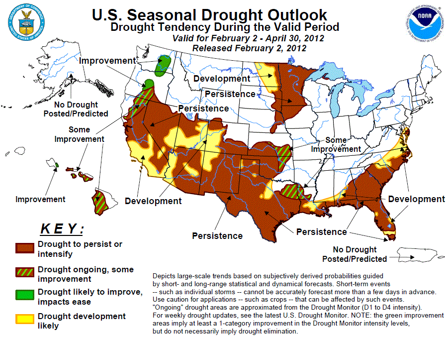
The updated drought outlook for February 2 - April 30, 2012 was based upon climate anomalies associated with La
Niña, short to medium range forecasts, climatology, and initial conditions. Since the last FMA’12 USDO on Jan.
19, heavy precipitation finally paid a visit to the Northwest after near-record dryness during December and
early January. SNOTEL Water-Year-to-date basin-averaged precipitation rose from 40-75 percent of normal on Jan.
16 to 60-110 in Washington, Oregon, and southern Idaho on Jan. 30. Farther south, values increased in
California’s Sierra Nevada and northern parts of Nevada and Utah, rising from 25-65 percent of normal on Jan. 16
to 50-85 percent on Jan. 30. Basin average snow water content (SWC) also increased as well, approximately
doubling from the Jan. 16 amount; however, the SWC totals were still below normal across much of the region. In
contrast, little or no precipitation fell across southern California, southern Nevada, and most of Arizona and
New Mexico during the past 2 weeks. Farther east, more precipitation in the south-central Plains and the
Southeast brought additional drought relief to Oklahoma, Texas, and the northern edge of the drought area in the
Southeast. Meanwhile, subnormal precipitation fell on southern Texas and from Florida northward to the
mid-Atlantic.
The ongoing La Niña event favors drought persistence and development for the next 3 months across the southern
tier of States, from southern California eastward into Florida and northward into the Carolinas. Much of this
same area will also have enhanced odds for above-normal temperatures (from Arizona and Utah eastward to the
Carolinas and mid-Atlantic). Although the Northwest finally received ample precipitation during the past two
weeks (usually expected in the Northwest during a La Niña), moderate drought still lingered in eastern
Washington, southern Oregon, most of California and Nevada, and central Utah from a very dry start to the
winter season. Unfortunately, short and medium-term forecasts maintain an upper-air ridge (high pressure) over
the Far West, diverting the storms to the north and keeping decent moisture away from the region. And with
another normally wet month (Feb) looking less so, the odds for significant drought improvement were lowered.
Therefore, this outlook is more pessimistic toward drought recovery in northern California and Nevada, with less
improvement and more persistence in these areas as compared to the Jan. 19 FMA USDO. To the south, despite
early winter snowfall in Arizona and New Mexico, the odds for subnormal precipitation and above-normal
temperatures across the Southwest are elevated in the monthly and seasonal outlooks. Therefore, persistence or
development is forecasted across most of California, the Great Basin, Southwest, and southern Plains. Some
improvement is possible along the northern drought boundary in the central Great Plains and lower Delta with
expected short-term moderate to heavy precipitation, favorable odds of above-normal February and FMA
precipitation in the middle Mississippi, Ohio, and Tennessee Valleys, and persistent bouts of wet weather in
this area since mid-October. Farther south and east, however, recent dryness and favorable odds of subnormal
precipitation in the short and long-term maintains drought along the Gulf and southern Atlantic Coasts and
expands it into the mid-Atlantic Coast. A dry (and cold) winter climatology, much below-normal precipitation
(minimal snow) since the Fall, and equal odd chances (1- and 3-month outlooks) elevates the chances for
persistence across the western Corn Belt and upper Midwest, with drought expansion possible in the central
Dakotas. Lastly, an updated study found that recent La Niñas in Hawaii brought drier conditions than earlier
events, meaning fewer events in wet tercile but not necessarily in the dry tercile. And since 4 out of 7 wet
season months have already occurred and the drought has worsened, Improvement was not used. But since Hawaii
can still get above-normal rainfall during the next 3 months which may be enough for a 1-category drought
improvement by April 30, using Persistence was too strong in the other direction. Therefore, Some Improvement
was the best forecast.
|
|
Tools used in the U.S. Drought Outlook (USDO) included the official updated CPC temperature and precipitation
outlooks for and the long lead forecast for February through April 2012, various medium- and
short-range forecasts and models such as the 6-10 day and 8-14 day forecasts, the most recent 384-hour 12Z GFS
total precipitation amounts, the soil moisture tools based on the GFS model and the Constructed Analogue on
Soil (CAS) moisture, the Climate Forecast System (CFS, versions 1 and 2) and the National Multi-Model Ensemble
(NMME) seasonal precipitation forecasts, the four-month Palmer drought termination and amelioration
probabilities, climatology, and initial conditions, composite standardized precipitation and temperature
seasonal (FMA) anomalies for all La Niña episodes and for a smaller set of back to back La Niña years, and an
updated recent study on precipitation in Hawaii during La Niña, El Niño, and Neutral condition events.
Since the La Niña event of 2010-2011, widespread moderate to extreme drought remains entrenched across parts of
the Southeast. La Niña conditions returned during fall 2011 and are expected to persist throughout the outlook
period. Drier conditions have recently spread northward along the Atlantic Coast into the Delmarva Peninsula
where D1 was just introduced this week in the U.S. Drought Monitor. In the short-term (Days 1-5), above-normal
precipitation is expected from eastern Texas to southern Mississippi and northeastward into the central
Appalachians, and this may provide some temporary short-term drought relief in the lower Delta and northern
drought edge in the Southeast. Precipitation tools after this (6-10 day, 8-14 day, 384-hour GFS, 1- and
3-months), however, favor below median precipitation across the Southeast and southern Atlantic Coasts which is
consistent with a La Niña event. Persistence or development can be expected across these areas. But with
favorable odds for above-normal precipitation at 1- and 3-months in the middle Mississippi, Ohio, and Tennessee
Valleys and Great Lakes region lurking just to the north of this region, plus frequent bouts of wet weather
since November in the lower Mississippi Valley and northern portions of the Southeast, the gradient between
improvement, persistence, and development is very tight, making the forecast for the lower Mississippi Valley
and central Gulf Coast States difficult.
Forecast confidence for the Delmarva Peninsula, Virginia, the Carolinas, and Georgia is moderate; low to
moderate for central Gulf Coast and lower Mississippi valley (Alabama, Mississippi, and Louisiana).
Although a wet late summer and early fall rainy season greatly eased drought conditions across the Florida
peninsula, the return of La Niña strongly favors drought development in central and south Florida. The
probabilities of below median rainfall for FMA are greater than 60 percent in the southern half of the state,
and this is Florida’s normal dry season (winter to early spring). Since the initial FMA outlook, moderate
drought (D1) has expanded southward into central and extreme southern sections of Florida with abnormal dryness
now covered all of the state. Severe to extreme drought continued across parts of the Florida Panhandle which
missed the surplus summer and early fall rainfall. The average water level at Lake Okeechobee (13.26 feet) was
still 1.39 feet below normal on Jan. 31. La Niña composites and the CPC February and February–April outlooks
also indicate a high probability for below median precipitation across the Florida Panhandle where persistence
is forecast.
Forecast confidence for Florida is high.
Across the central and southern Plains, additional surplus precipitation since the last USDO (Jan. 19) brought
further drought relief to most of Texas and Oklahoma. Unfortunately, dry weather was observed in eastern New
Mexico, southern and northwestern Texas, the Oklahoma Panhandle, southeastern Colorado, and Kansas. With odds
for above-normal temperatures (1- and 3-month outlooks) and subnormal precipitation (e.g. La Niña composites and
precipitation tools), persistence is favored across much of the southern Plains, with development in Texas areas
currently without drought. Although the 6-10 and 8-14 day outlooks favor above-normal rainfall in extreme
southern Texas, the long-term drought conditions and high probabilities for subnormal rainfall during a La Niña
outweighed suggestions for Some Improvement, thus persistence was kept in this region. However, some
improvement is forecast across eastern parts of Kansas and Oklahoma and the Arklatex region where the CPC
seasonal outlook indicates equal chances for below, near, or above precipitation, the 1-5 day HPC forecast
indicates moderate to heavy totals, and numerous bouts of wet weather have frequented these areas since late
October, improving or erasing drought.
Forecast confidence for the southern High Plains is high, and moderate for areas to the east (e.g. southeast
Kansas, eastern Oklahoma, and eastern Texas).
From mid-November into December, shortwave troughs digging into the desert Southwest have resulted in widespread
moderate to heavy snow across the higher elevations of Arizona and New Mexico, and above-normal precipitation at
lower elevation locations. As of January 16, water year to date (since Oct. 1) basin average snow water content
(SWC) and precipitation were running above average across the mountains of Arizona and New Mexico. However, the
values have slowly declined as little or no precipitation has fallen since late December, and temperatures have
averaged above normal during January. Still, Jan. 30 basin averaged precipitation and SWC were close to normal
in Arizona and above-normal in New Mexico. To the west, however, conditions have been drier in southern sections
of California and Nevada, and D0 and D1 has expanded into this region. Precipitation tools on all time scales
favor below median precipitation which is typical for a La Niña winter. In addition, the odds for above-normal
FMA temperatures are favorable, especially in eastern sections of the Southwest. Therefore, drought persistence
is forecast across the Southwest, with development in areas to the north (southeastern California, western
Arizona, and southern sections of Nevada, Utah, and Colorado).
Forecast confidence for the Southwest is moderate to high.
In mid-January, a surprising lack of early winter precipitation (not expected during a La Niña) in the Northwest
resulted in the introduction of severe drought (D2) to the Sierra Nevadas, moderate drought (D1) from central
California northward into central Washington and eastward into northwestern Nevada, and an expansion of abnormal
dryness (D0) across the Great Basin and into most of Idaho and northern Utah. Since then, however, heavy
precipitation during the past 2 weeks has somewhat eased drought conditions in the Northwest and Sierra Nevada.
As of January 16, snow water content values were less than 15 percent of average in the Sierras and 24 to 38
percent of average in the southern Cascades, but 2 weeks later had increased to 38 and 60 percent, respectively. It
should be noted that reservoir levels have not suffered yet due to the surplus 2010-11 winter precipitation and
cool and wet spring. Unfortunately, the wet weather missed the southern sections of California and Nevada, and
conditions have deteriorated. In addition, drier weather has returned to the Far West, and the short to medium
range forecasts (including the updated February outlook) indicate subnormal precipitation for the area.
Although there is a moderate signal for wetness among the various longer-lead precipitation tools in the
Northwest including northern California, the increasing odds for a drier February have led to a more pessimistic
forecast for northern California. Therefore, improvement is limited to areas farther north (e.g. Washington and
Oregon), with only some improvement in northern California. Persistence is favored across the rest of
California and Nevada, with development in the non-drought areas of those two states and into Utah. The drought
development is based on La Niña composites and the CPC monthly and seasonal precipitation outlooks that
indicated a tilt in the odds towards below median precipitation.
Forecast confidence for California and the Great Basin is moderate in the north, moderate to high in the south.
Drought coverage and intensity has remained nearly steady across the western Corn Belt and upper Mississippi
Valley since the previous outlook of January 5. The CPC February and February-April outlooks indicated equal
chances for below, near, or above median precipitation, except for slight above-normal FMA precipitation odds in
the western Great Lakes region. However, a dry climatology limits prospects for significant drought relief, and
very dry (little or no snow) and mild conditions since the Fall will require excessive precipitation for any
relief. In addition, since the ground and streams in this region freeze over during the winter months, it is
likely that the benefits of improved moisture would not be realized until the spring thaw which normally occurs
in March or April. Therefore, persistence is favored across much of the western Corn Belt and upper Midwest,
with some possible expansion into North Dakota based upon current conditions (90-day precipitation between 25
and 50 percent of normal).
Forecast confidence for the western Corn Belt and upper Midwest is moderate.
Drought redeveloped during the summer months across the western portions of the Hawaii, but recent winter
rainfall reduced drought coverage across Kauai and Oahu. Farther east, adequate rainfall did fall on the
windward sides of Maui, Molokai, and the Big Island, but have yet to materialize on the leeward sides of these
islands during this La Niña event. Traditionally, a La Niña event was thought to bring surplus rainfall to
Hawaii. However, an updated study found that recent La Niña events (past 30 years) brought drier conditions
than earlier La Niña events (1957-1986), meaning fewer events in the wet tercile but not necessarily in the dry
tercile. And with 4 of 7 wet season months already finished and the drought worsening, improvement is not
appropriate. But since Hawaii can still get above-normal rainfall during the next 3 months, persistence is not
correct either. Instead, some drought improvement is forecasted for the leeward sides of the Hawaiian Islands,
with improvement for the windward side of Oahu.
Forecast confidence for the Hawaii is moderate.
|


