|
Latest Seasonal Assessment -
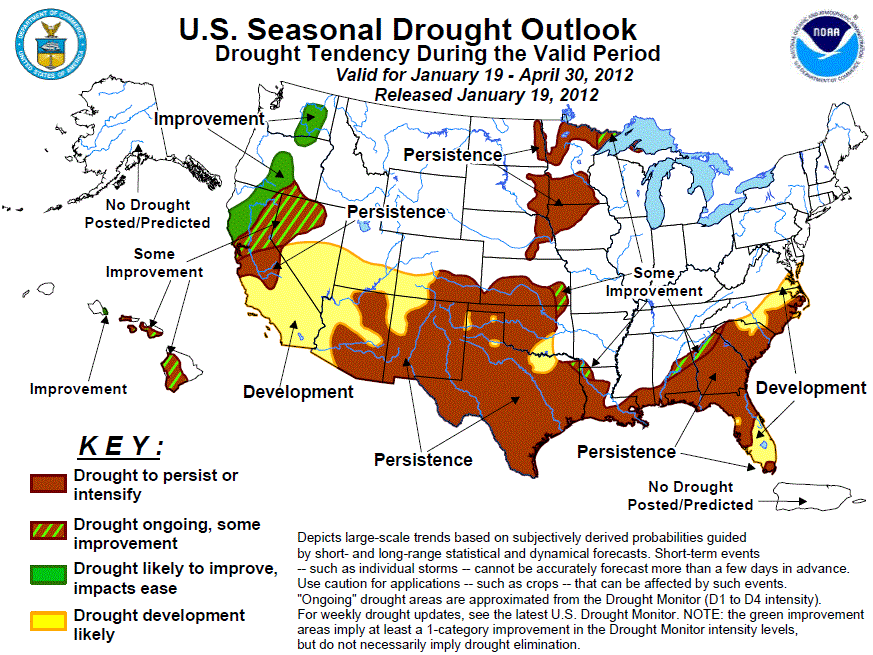
The drought outlook for January 19 - April 30, 2012 was based upon climate anomalies associated with La Niña,
short to medium range forecasts, climatology, and initial conditions. Frequent periods of precipitation somewhat
improved drought conditions across the southern Plains and parts of the Southeast during the past two months.
However, a return of dry weather and the ongoing La Niña favor persistence across most of eastern New Mexico,
Texas, southern Kansas, western Oklahoma, and Texas. Farther east, persistence or development can be expected
across much of the lower Southeast, with the highest forecast confidence in Florida. Some improvement is
possible along the northern drought boundary in the South with short and medium-term heavy precipitation
expected, plus favorable odds of above-normal FMA precipitation in the Ohio and Tennessee Valleys and Great
Lakes region. The lack of early winter precipitation, unexpected in the Northwest during a La Niña, resulted in
moderate drought development and expansion of abnormal dryness across eastern Washington, southern Idaho, most
of Oregon, California, and Nevada, and northern Utah. However, short and medium-term forecasts and the 3-month
(FMA'12) precipitation outlook favor improvement in northern sections (Washington, Oregon, northern California),
with some improvement in northeastern California and northwestern Nevada. Despite the early winter snowfall in
Arizona and New Mexico, the odds for drought persistence and development across the Southwest are elevated.
Therefore, persistence or development is forecasted across central and southern California, Arizona, southern
sections of Nevada, Utah, and Colorado, and western New Mexico. A relatively dry winter climatology and equal
odd chances (1- and 3-month outlooks) elevates the chances for persistence across the western Corn Belt and
upper Midwest. An exception was near Lake Superior (Some Improvement) where the 3-month precipitation outlook
slightly favored above-normal precipitation. In Hawaii, a La Niña event is normally considered to bring enhanced
rainfall to the islands. However, a new study comparing Hawaiian rainfall during recent La Niñas, El Niños, and
Neutral conditions indicated minimal odds for improvement on the leeward sides during La Niñas, so only some
improvement was forecast for the Hawaiian leeward sides. Improvement was kept for Oahu's windward side.
|
|
Tools used in the U.S. Drought Outlook (USDO)
included the official CPC temperature and precipitation outlooks for February 2012
and the long lead forecast for February 2012 - April 2012, various medium- and short-range forecasts and
models such as the 6-10 day and 8-14 day forecasts, the soil moisture
tools based on the GFS model and the Constructed Analogue on Soil (CAS) moisture, the Climate Forecast
System (CFS, versions 1 and 2) and the National Multi-Model Ensemble (NMME) seasonal precipitation forecasts,
the four-month Palmer drought termination and amelioration probabilities, climatology, and initial conditions,
and composite standardized precipitation and temperature seasonal (FMA) anomalies for all La Niña episodes and
for a smaller set of back to back La Niña years.
Since the La Niña event of 2010-2011, widespread moderate to extreme drought remains entrenched across parts of
the Southeast. La Niña conditions returned during fall 2011 and are expected to persist throughout the outlook
period. In the short-term (Days 1-5, 6-10, and 8-14), above-normal precipitation is expected from Mississippi and
Alabama northeastward into eastern North Carolina, and this may provide some temporary short-term drought relief
in those areas. Precipitation tools on longer time scales (1- and 3-months), however, favor below median
precipitation and above-normal temperatures across the Gulf and southern Atlantic Coasts (northward to extreme
southeastern Virginia) which is consistent with a La Niña event. Persistence or development can be expected
across these areas. But with favorable odds for above-normal precipitation in the Ohio and Tennessee Valleys
and Great Lakes region lurking just to the north of this region, the northern border of the drought in Alabama
and Georgia was set to some improvement.
Forecast confidence for Virginia, the Carolinas, Georgia, Alabama, and Mississippi is moderate.
Although a wet late summer and early fall rainy season greatly eased drought conditions across the Florida
peninsula, the return of La Niña strongly favors drought development in central and south Florida. The average
water level at Lake Okeechobee was still more than a foot below normal at the beginning of the dry season (late
fall to late spring), and probabilities of below median rainfall through the winter are greater than 60 percent
in the southern half of the state. Since the previous outlook, moderate drought (D1) has expanded southward
into central and extreme southern sections of Florida, an abnormal dryness now covered all of the state. Severe
to extreme drought continued across parts of the Florida Panhandle which missed the surplus summer and early
fall rainfall. La Niña composites and the CPC February – April outlook also indicate a relatively high
probability for below median precipitation and above-normal temperatures across the Florida Panhandle where
persistence is forecast.
Forecast confidence for Florida is high.
Due to a persistent upper-air pattern (wet) during late October into December, Missouri, Arkansas, and much of
Mississippi are drought-free. Drought conditions were ameliorated in northern Louisiana since mid-December,
with minor improvements to the drought status across the remainder of Louisiana and the Mississippi Gulf Coast.
La Niña composites, along with the precipitation tools on longer time scales favor persistence across much of
the lower Mississippi Valley. Some short-term improvement, however, may occur in the next 2 weeks based upon
the Days 1-5, 6-10, and 8-14 forecasts.
Forecast confidence for the lower Mississippi Valley is moderate.
Across the central and southern Plains, continuing precipitation brought additional drought relief to southern
Kansas, Oklahoma, eastern New Mexico, and much of Texas. During the past 30 days, twice the normal
precipitation had fallen on eastern New Mexico, central and western Texas, the Texas and Oklahoma Panhandles,
southeastern Colorado, and southern Kansas. Although beneficial precipitation fell during November and
December, dry weather has returned to the southern Plains since Christmas. With high odds for above-normal
temperatures (1- and 3-month outlooks) and subnormal precipitation (e.g. La Niña composites and precipitation
tools), persistence is favored across much of the southern Plains, with development in Texas areas currently
without drought. However, some improvement is forecast across southeast Kansas and the Arklatex region where
the CPC seasonal outlook indicates equal chances for below, near, or above precipitation and the 6-10 and 8-14
day outlook indicates enhanced odds for above median precipitation.
Forecast confidence for the southern High Plains is high, and moderate for areas to the east (e.g. southeast
Kansas, eastern Oklahoma, and eastern Texas).
From mid-November into December, shortwave troughs digging into the desert Southwest have resulted in widespread
moderate to heavy snow across the higher elevations of Arizona and New Mexico, and above-normal precipitation at
lower elevation locations. As of January 16, water year to date (since Oct. 1) basin average snow water
content and precipitation are running above average across the mountains of Arizona and New Mexico, although
they have gradually declined since the last drought outlook (January 5) as little or no precipitation has fallen
since late December. Despite the early winter snowfall across Arizona and New Mexico, precipitation tools on
all time scales favor below median precipitation which is typical for a La Niña winter. In addition, the odds
for above-normal FMA temperatures are favorable, especially in eastern sections of the Southwest. Therefore,
drought persistence is forecast across the Southwest, with development in areas to the north (southeastern
California, western Arizona, and southern sections of Nevada, Utah, and Colorado).
Forecast confidence for the Southwest is moderate.
A surprising lack of early winter precipitation (not expected during a La Niña) in the Northwest resulted in the
introduction of severe drought (D2) to the Sierra Nevadas, moderate drought (D1) from central California
northward into central Washington and eastward into northwestern Nevada, and an expansion of abnormal
dryness (D0) across the Great Basin and into most of Idaho and northern Utah. During the past 30 days,
precipitation deficits exceeding 4 inches were common across northern and central California. As of January 16,
snow water equivalent values were less than 15 percent of average in the Sierras and 24 to 38 percent of average
in the southern Cascades. It should be noted that reservoir levels have not suffered yet due to the surplus
2010-11 winter precipitation, and cool and wet 2011 spring. Fortunately, a stormy and wet weather pattern is
forecast for much of the Northwest during the next 2 weeks, extending southward into central California.
Unfortunately, dry weather is expected in areas farther south. With the short-term wetness and a moderate
signal for wetness among the various longer-lead precipitation tools, improvement is forecast for Washington,
Oregon, and northwestern California, with some improvement in north-central California and northwestern Nevada.
Persistence is favored across central California, with development in southern sections of California and
Nevada. The drought development is based on La Niña composites and the CPC seasonal precipitation outlook that
indicated a tilt in the odds towards below median precipitation.
Forecast confidence for California and the Great Basin is moderate.
Drought coverage and intensity has remained nearly steady across the western Corn Belt and upper Mississippi
Valley since the previous outlook of January 5. The CPC February and February-April outlooks indicated equal
chances for below, near, or above median precipitation, except for slight above-normal FMA precipitation odds
in the western Great Lakes region. A dry climatology limits prospects for significant drought relief. In
addition, since the ground and streams in this region freeze over during the winter months, it is likely that
the benefits of improved moisture would not be realized until the spring thaw, which normally occurs in March
or April. Therefore, persistence is favored across much of the western Corn Belt and upper Midwest, except for
some improvement possible (by late April) in the area near Lake Superior.
Forecast confidence for the western Corn Belt and upper Midwest is moderate.
Drought redeveloped during the summer months across the western portions of the Hawaii, but recent winter
rainfall reduced drought coverage across Kauai and Oahu. Farther east, adequate rainfall did fall on the
windward sides of Maui, Molokai, and the Big Island, but have yet to materialize on the leeward sides of these
islands during this La Niña event, and further deterioration has occurred there. During a La Niña winter,
wetter than average conditions are usually expected in Hawaii, particularly after January, but a new study has
revealed otherwise. It was found that during recent La Niña events, there was much less certainty of above
normal rainfall on the leeward sides, although the windward sides were still wet. With this new information,
only some drought improvement is forecasted for the leeward sides of the Hawaiian Islands, although improvement
is expected for the windward side of Oahu.
Forecast confidence for the Hawaii is moderate.
|


