|
Latest Seasonal Assessment -
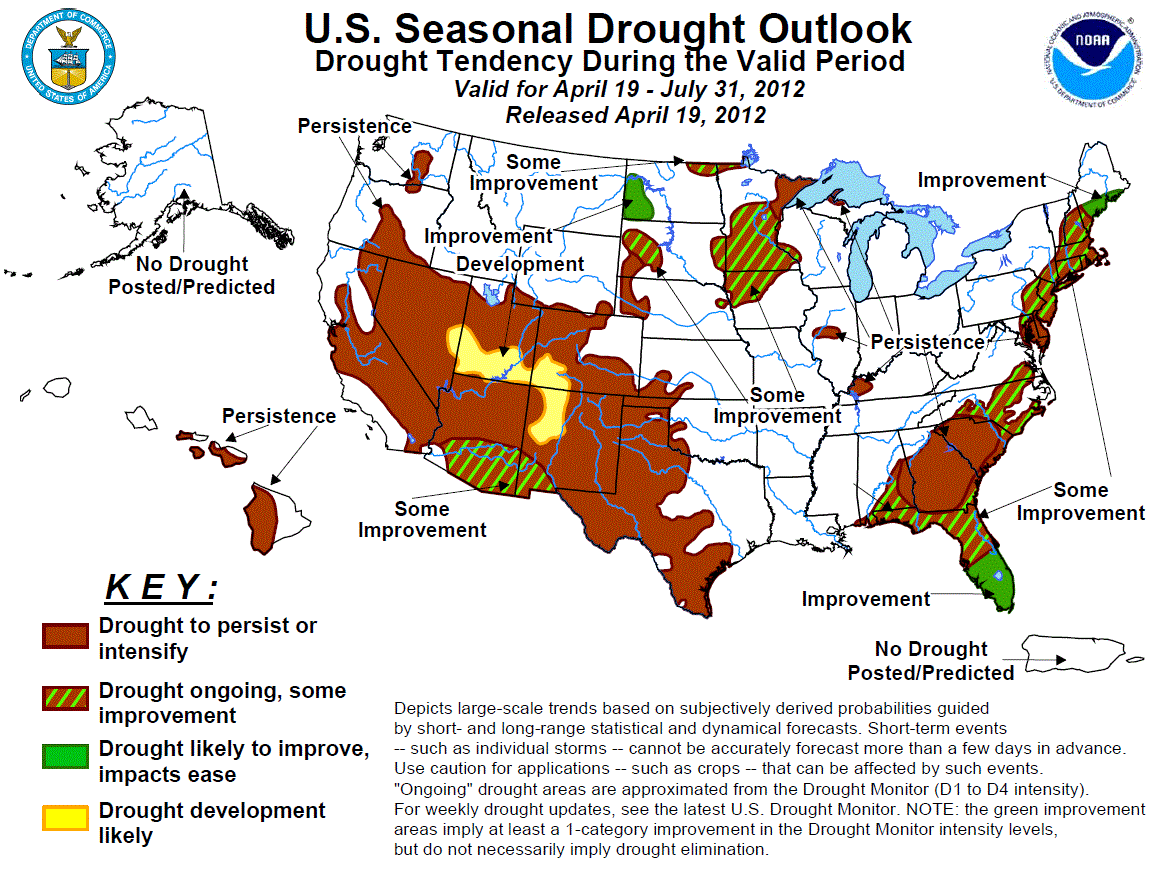
The Drought Outlook for April 19 – July 31, 2012 is based on short-, medium-, and long-range forecasts, initial conditions,
past years with similarly-evolving weather and equatorial Pacific sea surface temperature patterns, objective weather and
climate model output, and climatology. Since the release of the previous Drought Outlook issued on April 5, 2012, warm and dry
weather caused drought to intensify and expand from the Gulf Coast and the south Atlantic states northward along the Eastern
Seaboard. Farther west, conditions intensified to drought status in relatively small sections of western Kentucky, central
Illinois, and the central High Plains. Overall, the current Drought Outlook is not optimistic. Substantial improvement is
expected only in southern Maine, the southern half of Florida with the onset if its rainy season, and western North Dakota.
Meanwhile, limited surface moisture improvement is anticipated in the rest of the Northeast, North Carolina, the immediate
southern Atlantic coastline, northern Florida and adjacent Alabama, and the upper Midwest. In addition, late-period monsoonal
rains could bring limited improvement to southern sections of New Mexico and Arizona. Drought should persist where it exists
elsewhere (including Hawaii) and may expand to cover the central Rockies. It should be noted that the Drought Outlook is
hampered by uncertainty regarding the track and intensity of a storm system that could drop heavy precipitation on part or all
of the Atlantic Seaboard during April 21 – 23. This Drought Outlook assumes, as a compromise, a storm of moderate strength that
affects the entire East Coast.
|
|
Tools used in the U.S. Drought Outlook (USDO) included the official CPC temperature and precipitation outlooks
for May 2012 and the long lead forecast for May through July 2012,
various medium- and short-range forecasts and models such as the 6-10 day and
8-14 day forecasts, the most recent 384-hour GFS total precipitation amounts, the soil moisture tools
based on the Constructed Analog on Soil (CAS) moisture, the Climate Forecast System (CFS, versions 1 and 2), the
four-month Palmer drought termination and amelioration probabilities, climatology, and initial conditions.
Along the eastern tier of states, the forecast is based primarily on initial conditions and climatology. In the first few days of the period, there is the potential for a strong storm system to develop and spread heavy precipitation across most of the areas currently affected by drought. A large part of this area could receive a few inches of rain; however, there is an unusually large degree of uncertainty regarding the evolution of this system, and less-widespread light to moderate precipitation could easily be the result. This outlook is based on a compromise solution that assumes moderate precipitation will fall on most of the region. The rest of April should be drier than normal, and the longer-range outlooks for May – July 2012 favor neither drier- nor wetter-than-normal conditions. Climatologically, rainfall increases markedly for the latter half of the period across peninsular Florida, and increases slightly along other parts of the immediate Atlantic and Gulf coastlines in the Southeast. Given all of the uncertainties, the outlook boils down to two factors: First, improvement is expected in southern Florida where there is a significant climatological increase in rainfall and summer progresses; Second, all other things being equal, drought has the best chance of persisting where the intensity and duration are currently the greatest and where there is no sharp climatological increase in rainfall – along the Delmarva Peninsula, and across South Carolina, Georgia, and adjacent areas away from the immediate Atlantic and Gulf Coasts. The limited improvement expected elsewhere is a reflection of the fact that extant drought is of lesser intensity and shorter duration in these areas, and not the result of a wetter forecast.
Forecast confidence for the Southeast is moderate, and for the Northeast is low.
In the upper Midwest and northern Plains, May – July is climatologically one of the wettest times of the year. Typically 35 to 45 percent of annual precipitation falls during this 3-month period from the eastern Dakotas eastward through Iowa and Minnesota, climbing to between 45 and 60 percent in the northern Plains. Near- to above-normal precipitation is expected for the remainder of April – especially along the northern tier – and the sum of indicators does not lean significantly toward dryness or wetness for May – July. However, both constructed analogs and CFS output leans wet in the northern and eastern tiers of the region, especially in western North Dakota, and toward dryness across western Nebraska. All of this synthesizes into a forecast for improvement in western North Dakota (where indicators and climatology lean the wettest) and for persistence in western Nebraska (where forecasts on all time scales lean drier) and northeastern Minnesota (home of the region’s most entrenched drought conditions). Limited improvement is anticipated in other drought areas. It should be noted that since this is a wet time of year for the region – particularly in the western reaches – the lack of a convincing preponderance of indicators implies a large range of possible outcomes by the end of the period.
Forecast confidence for the upper Midwest and northern Plains is low.
For most of the southwestern and western part of the country, drought is expected to persist in most locations and expand into the central Rockies. This is a relatively wet time of year for the southern High Plains and neutral to dry farther west, especially in the desert Southwest and California. Some precipitation is expected in northern parts of the region in late April, but thereafter the odds lean toward a drier-than-normal May – July through the northern half of the area. There is no discernible tilt of the odds farther south. Surface moisture is depleted in late spring and summer across this region due to the frequency of hot, dry, and windy weather. In addition, mountain snowpack, the source of a lot of the region’s moisture, is starting off below normal, and as a result summer streamflows are expected to be abnormally low. In addition, May – July is expected to be warmer than normal, potentially enhancing the typical surface moisture depletion that always happens during this time of year. The result is a forecast for persisting drought that could expand into the central Rockies if there is sufficiently enhanced seasonal surface moisture draw-down. The only exception is in southern sections of New Mexico and Arizona, where the onset of monsoonal rains in July should bring some surface moisture back.
Forecast confidence across the southwestern and western parts of the nation is high.
Finally, Hawaii is transitioning into its drier time of the year, and there is little chance for any lasting drought improvement.
Forecast confidence in Hawaii is high.
|


