|
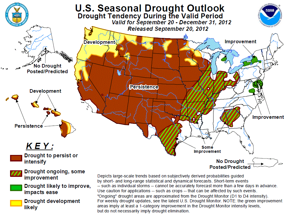
Latest Seasonal Assessment -
Drought amelioration occurred across the middle Mississippi and Ohio Valleys from late August to mid-September, while drought
intensified and expanded across the Great Plains, upper Mississippi Valley, and northern Rockies. Drought is expected to persist
across most of the Great Plains and upper Mississippi Valley, while prospects for improvement increase across the Ohio Valley, middle
Mississippi Valley, and southern Texas. Drought also expanded or intensified across the northern Rockies where additional development
or persistence is expected. Development forecast across the Pacific Northwest and northern California is consistent with the CPC
monthly and seasonal outlooks calling for enhanced odds for below median precipitation during an increasingly wet time of year. An
active monsoon resulted in drought improvement across parts of the Southwest since late August. The end of the monsoon offers
decreasing chances for widespread improvement and persistence is now forecast for the Southwest. Improvement is expected for the
small areas of drought across the mid-Atlantic and western New York. No changes were made to the previous outlook in Hawaii where
persistence or development can be expected.
|
|
Discussion for the Seasonal Drought Outlook
Tools used in the U.S. Drought Outlook (USDO) included the official CPC temperature and precipitation outlooks
for October 2012 and the long lead forecast for October through December 2012, various medium- and short-range forecasts and
models such as the 6-10 day and 8-14 day forecasts, the most recent 384-hour GFS total precipitation amounts, the
soil moisture tools based on the Constructed Analog on Soil (CAS) moisture, the Climate Forecast System (CFS, versions 1 and 2),
the four-month Palmer drought termination and amelioration probabilities, climatology, and initial conditions. El Niño
precipitation anomalies for October through December were also considered.
Some improvement is forecast for the long-term drought areas of eastern Alabama and Georgia. Following a moderate
rainfall (0.5 – 1.5 inches) across this region during mid-September, enhanced odds for below median precipitation are
forecast during the remainder of September. Although October and November are a relatively dry time of year for the
Southeast, the CPC outlook for OND calls for enhanced odds for above median precipitation for eastern Alabama and Georgia. Therefore, some improvement is forecast for this region but long-term precipitation deficits are not expected to be eliminated.
Forecast confidence for the Southeast is moderate.
A widespread moderate to heavy rainfall during mid-September occurred across the mid-Atlantic and western New York.
The 6-10/8-14 day outlooks call for near to above median precipitation for these areas, while the CPC monthly outlook
indicates enhanced odds for below median precipitation for western New York. Soil moisture currently ranks in the 20th to
30th percentile with precipitation deficits since January 1 ranging from 5 to 10 inches below normal. The CPC outlook for
OND calls for equal chances of below, near, or above median precipitation. Since evaporation rates are lower and
precipitation is evenly distributed throughout the year, above or near median precipitation would improve drought
conditions across the mid-Atlantic and western New York.
Forecast confidence for the mid-Atlantic and western New York is high.
Due to an increase in rainfall during August and early September, largely from the remnants of Isaac, significant
amelioration of drought occurred across Arkansas, southeast Missouri, and the eastern Corn Belt. Soil moisture levels and
stream flows have mostly recovered in these areas since mid-summer. The seasonal decline in temperatures and equal
chances for below, near, or above median precipitation in the CPC outlook for OND result in a forecast for some improvement across the middle Mississippi and Ohio Valleys.
Forecast confidence for the middle Mississippi Valley and Ohio Valley is moderate.
According to the USDM, extreme to exceptional drought covers nearly all of Oklahoma with varying drought intensity across
Texas. A relatively dry climatology favors persistence across western Oklahoma and the Texas Panhandle. Prospects for
some improvement increase across the southern half of Texas where climatologically, conditions do not become drier during
OND, and the CPC monthly/seasonal outlooks indicate a tilt in the odds towards above median precipitation. El Niño
precipitation composites indicating above median precipitation across south Texas are also considered.
Forecast confidence for Oklahoma and Texas is moderate.
During the past month, drought coverage increased across the northern Great Plains and upper Mississippi Valley with
drought intensifying across the central Great Plains. According to the USDM, most of Kansas, Nebraska, and southern South
Dakota are designated in the extreme or exceptional drought category. A relatively dry climatology favors persistence
across the northern/central Great Plains and upper Mississippi Valley. Development is forecast for areas in the Dakotas,
Minnesota, and western Wisconsin that are currently designated with the D0 category (abnormal dryness) in the USDM. The
6-10 and 8-14 day outlooks call for enhanced odds for below median precipitation across the northern Great Plains and
upper Mississippi Valley.
Forecast confidence for the northern/central Great Plains and upper Mississippi Valley is high.
A relatively dry climatology and increased chances for below median precipitation/above normal temperatures favor
persistence and development across Montana. During the past 30 days, drought expanded in Montana where dry, warm weather
prevailed.
Forecast confidence for the northern Rockies is high.
During September, dry weather accompanied by unseasonably warm temperatures also affected the Pacific Northwest. As of
September 20, multiple large wildfires are burning across the Pacific Northwest. Since tools on all time scales indicate
enhanced odds for below median precipitation, persistence or development is forecast for the Pacific Northwest and
northern California. El Niño precipitation composites indicating below median precipitation across these areas are also
considered.
Forecast confidence for the Pacific Northwest and northern California is high.
Since the previous outlook issued on September 6, improvement across the Southwest is replaced with persistence as the
monsoon ends. Although localized improvement is possible with any late monsoon rainfall during late September into the
beginning of October, widespread improvement is not expected. Therefore, a large area of persistence is forecast across
the Southwest. Persistence is also forecast for the central Rockies where most tools indicate weak precipitation signals.
Forecast confidence for the Southwest and central Rockies is low.
In Hawaii, October through December become progressively wetter. However, the long-lead forecast indicates enhanced
chances for below-normal rainfall. As a result, drought is expected to persist in existing areas and slowly expand into
other parts of the state, much like the previous Drought Outlook. Still, the fact that the Islands are getting
climatologically wetter during the period does imply that the chances for drought-relieving rains improve later in the
period, even if only based on climatology.
Forecast confidence for Hawaii is low.
|


