|
Latest Seasonal Assessment -
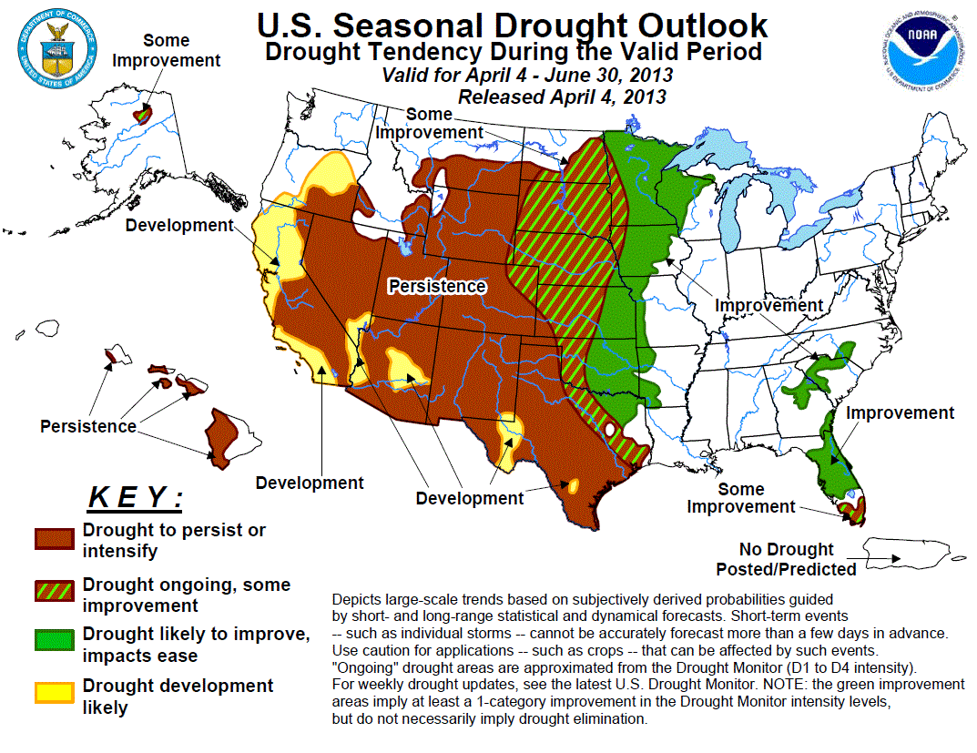
The drought outlook for April 4 - June 30, 2013 is based primarily on short-, medium-, and long-range forecasts, initial
conditions, and climatology. During the past two months, major improvement occurred across Georgia and South Carolina where
additional improvement is expected. Improvement also is forecast to extend south to include the Florida peninsula. The duration
of the drought across south Florida is expected to be short-lived as the rainy season typically begins during June. Improvement
is forecast across eastern Kansas, eastern Oklahoma, and northeast Texas, but prospects for drought improvement decrease
further southwest across the southern high Plains and south Texas. Some improvement is expected across the intense drought
areas of the northern/central Plains, while improvement is more likely across the upper Mississippi Valley. Drought is
forecast to persist for much of the West and expand across northern California and southern Oregon. Some improvement is
expected for the drought area across northern Alaska, while persistence is forecast for the Hawaiian Islands.
|
|
Tools used in the U.S. Drought Outlook (USDO) included the CPC temperature and
precipitation outlooks for April 2013 and
April through June 2013, various short- and medium-range forecasts and models
such as the 5-day and experimental 7-day WPC precipitation totals (released April 3), 6-10 day and 8-14 day forecasts
(released April 3), the NAEFS precipitation outlooks, the soil moisture tools based
on the Constructed Analog on Soil (CAS) moisture, dynamical models (CFSv2, NMME, and IMME), the 384-hour total
precipitation forecasts from several runs of the GFS, the four-month Palmer drought termination and amelioration
probabilities, climatology, and initial conditions.
Frequent rainfall during February and March resulted in major drought improvement across Georgia and South Carolina. The
U.S. Drought Monitor released on March 26 indicated that Georgia was free of severe drought for the first time since
September 2010. More than 80 percent of Georgia was depicted with severe drought levels or worse as recent as late
January. Levels on Lake Lanier have recovered to near bank full. Drought improvement is likely to continue across Georgia
and South Carolina with additional rainfall during the next two weeks.
Forecast confidence for Georgia and South Carolina is high.
Improvement is forecast for much of the Florida peninsula where two rounds of beneficial rainfall can be expected during
the next week. The updated CPC outlook for April favors above median precipitation across the northern Florida peninsula.
As of April 2, the level of Lake Okeechobee is at 13.8 feet which is close to average for the beginning of April.
Therefore, the drought affecting south Florida is related to short-term precipitation deficits and low soil moisture
levels. Some improvement is forecast for far southern Florida since rainfall amounts are forecast to be lower than the
remainder of the Florida peninsula during early-to-mid April. Drought development (forecast in the previous outlook dated
March 21) is not expected due to April rainfall and the wet season beginning around June 1.
Forecast confidence for Florida is low.
The U.S. Drought Monitor from March 26 depicts Texas covered by 87 percent of drought and more than 60 percent of severe
(D2) to exceptional (D4) drought conditions. The development forecast across southeast Texas in the previous U.S. Drought
Outlook on March 21 is removed due to expected short-term rainfall and the updated CPC April outlook calling for enhanced
odds for above median precipitation in this region. Improvement or some improvement is expected across the northeast
quarter of Texas since model guidance indicates a wet pattern during early-to-mid April across this region. Persistence
and development are forecast for west and south Texas where the CPC seasonal outlook favors below median precipitation
and above normal temperatures.
Forecast confidence for Texas is moderate.
The updated U.S. Drought Outlook is more optimistic for improvement across the south-central Plains, especially across
eastern Kansas and Oklahoma. An upper-level trough forecast to develop across the west-central U.S. favors a wet pattern
during early-to-mid April across these areas. The past several runs of the GFS model consistently indicate several inches
of rainfall for southeast Kansas and eastern Oklahoma during the next two weeks. Meanwhile, persistence is forecast
across the southern high Plains where the seasonal outlooks favor below median precipitation and above normal temperatures.
In addition, much lighter rainfall amounts are expected across the southern high Plains during the next two weeks.
Forecast confidence for the southern Plains is moderate.
Some improvement forecast for the northern and central Plains is based largely on the annual cycle of precipitation and
the absence of a dry signal in the CPC monthly/seasonal precipitation outlooks. 40 to 50 percent of the annual
precipitation occurs during AMJ across much of the northern and central Plains. Although the drought will likely not be
eliminated during the next three months, at least some improvement across this region is expected. Adequate precipitation
during May and June and a lack of early summer heat waves are critical for any improvement to occur.
Forecast confidence for the northern and central Plains is low.
According to the National Operational Hydrologic Remote Sensing Center on April 2, snow-water equivalent values range
from 2 to 5 inches across the upper Mississippi Valley. It should be noted that is unclear how much of the spring runoff
can recharge the dry subsoils. AMJ is a relatively wet time of year for the upper Mississippi Valley. The 6-10/8-14 Day
outlooks from April 3 favor above median precipitation in this region. Due to these factors, improvement is expected
across the upper Mississippi Valley. Prospects for improvement are highest across southeast Minnesota and Wisconsin where
drought levels are less intense and the seasonal outlook favors above median precipitation.
Forecast confidence for the upper Mississippi Valley is moderate.
Persistence is expected for much of Colorado, New Mexico, Utah, Nevada, and Arizona due to low snow-water equivalent
values (around 75% of normal) and below average streamflows forecast for the spring and early summer. Enhanced odds for
below median precipitation and above normal temperatures during AMJ also favor persistence. Recent wetness, expected
short-term precipitation, and the lack of a dry signal during AMJ lead to a forecast of some improvement across northeast
Colorado.
Forecast confidence for Colorado, New Mexico, Utah, Nevada, and Arizona is high.
Similar to the interior Southwest, snow-water equivalent values are also below average across California and southern
Oregon. Following a wet start to the winter, unseasonably dry conditions affected these areas during the past three
months. According to the U.S. Drought Monitor on April 4, abnormal dryness (DO) covers northern California and parts of
southern/eastern Oregon. Below median precipitation is favored during AMJ across these same areas. Therefore,
persistence and development is forecast for this region. Precipitation typically decreases rapidly later in the spring
with little to no prospects for improvement after April.
Forecast confidence for California and southern Oregon is high.
Snow-water equivalent values are running slightly below average across the northern Rockies. Since tools on most time
scales offer weak precipitation signals, persistence is forecast for the northern Rockies and adjacent Plains. However,
forecast confidence is low since AMJ is relatively a wet time of year across most of Montana and Wyoming.
Forecast confidence for the northern Rockies is low.
Mountain snowpack was 50 to 75 percent of normal on March 1, 2013 across the drought area in north-central Alaska which
is a slight increase from one month ago. Some improvement is forecast for this region.
Forecast confidence in Alaska is moderate.
Moderate to extreme drought covers western sections of the individual Hawaiian Islands from Oahu southeastward through
the Big Island. Persistence is forecast for these leeward areas since odds for improvement decrease significantly during
May and June.
Forecast confidence in Hawaii is moderate.
|


