|
| |
 |
| |
|
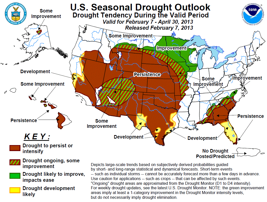
February - April 2013
|
| |
|
Outlook Graphic: GIF PDF 
|
| |
|
Latest Seasonal Assessment -
During the past 3 weeks (since mid-January), weather conditions have been quite variable across the lower 48 States. During
the first week, mild and wet weather enveloped the Southeast and mid-Atlantic while cold and dry conditions prevailed in the
West. By week 2, temperatures moderated in the West as some precipitation fell, especially in Arizona and along coastal Pacific
Northwest; however, much colder and drier conditions returned to the eastern half of the Nation. The most recent week saw
above normal readings spread across much of the contiguous U.S., with moderate to heavy precipitation falling on the eastern
half of the Nation. Early in the period, mild and wet weather prevailed in Alaska while showers have increased in coverage and
intensity across much of Hawaii, especially on Kauai and Oahu and the windward sides of the remaining islands.
Year-to-date precipitation (to February 5) has been subnormal in the Far West, central and northern Plains, New England, and
along the eastern Gulf and southern Atlantic States. The greatest deficits (3 to 6 inches, locally more than a foot) have
accumulated along the Washington, Oregon, and California coasts, in the Cascade and Sierra Nevada Mountains, and from the
Florida Panhandle northeastward into the coastal Carolinas. In contrast, surplus precipitation has fallen on the Four Corners
Region, southern Plains, most of the Mississippi, Tennessee, and Ohio Valleys, southern half of the Appalachians, and the
mid-Atlantic. January 1-February 5 temperatures have averaged below normal in the West, close to normal in the Plains, upper
Midwest, and mid-Atlantic, and above normal in the Southeast and New England.
Accordingly, some drought expansion has occurred over the past 3 weeks in Florida, southern Alabama and Georgia, the coastal
Carolinas, and parts of Texas. In contrast, improvement was recorded along the northwestern Southeast drought edge and in the
mid-Atlantic. Some improvement was also made in parts of the middle and lower Mississippi Valley (from Wisconsin to Arkansas),
in the Four Corners region, southern coastal California, and Hawaii. The worst conditions (D3 to D4) have stubbornly persisted
in the middle third of the Plains, and in central Georgia.
The updated monthly temperature and precipitation outlooks for February (released Jan. 31) were different from the initial
February outlooks released Jan. 17. The latest monthly outlooks kept the odds for above normal precipitation in the northern
Plains and upper Midwest, but expanded it southeastward into the Great Lakes region and upper Ohio Valley. In addition,
enhanced chances for wetness were now found in the Four Corners Region. With the latter wet probability, odds for subnormal
precipitation in the Southwest were now shifted to the central Pacific Coast and along the Gulf Coast. Above-normal February
temperatures were expected across the South, from the southern Rockies eastward to the southern Atlantic Coast, with the best
chances for subnormal readings in the middle third of the Far West.
As a reminder, the three month precipitation and temperature outlooks (released Jan. 17) favored a much drier pattern across
the southern third of the Nation (from central California to the eastern Gulf Coast). This would limit the prospects for
further drought improvements during the latter end of the wet season in California, Nevada, and western Arizona, except that
the updated monthly precipitation outlook called for enhanced odds of surplus precipitation. Due to the latter forecast, some
improvement is possible, mainly from the expected February precipitation, in the Four Corners region. Further east, this also
marks a change from recent wet conditions in the southern Plains and western Gulf Coast as drought development and persistence
is forecast for Texas by the end of April. Similarly, drought development and persistence is possible in the eastern Gulf Coast
States (and from the updated monthly outlook), but less likely further north (equal chances). In the short and medium term,
however, very heavy rains are forecast for the central Gulf Coast. As a result, no development was added here, and instead
some improvement was expanded southward into southern Alabama and extreme western Florida. Farther north, enhanced
probabilities of surplus precipitation across the northern U.S. (from the northern Rockies eastward to the upper Midwest and
into the western Corn Belt) increase the odds for drought improvement. Some improvement is possible across the middle
Mississippi Valley and the Piedmont, the latter area from wetness forecasted in the short and medium-term period.
Although CPC odds favored subnormal February and FMA rainfall, rainfall intensity and coverage has increased during the past
several weeks across Hawaii, especially on Kauai and Oahu and the windward side of the remaining islands, reducing drought
across the state. With the lack of an El Niño event (ENSO neutral) and the normal wet season still ongoing, it is difficult to
bet against the wet season, especially in the northern and western islands. Accordingly, some improvement was forecast for the
leeward sides of Oahu, Molokai, and Lanai, with persistence remaining on the leeward sides of Maui and the Big Island. In
Alaska, with odds for above-normal February precipitation, the Koyukuk Basin of north-central Alaska was kept as some
improvement in anticipation of increasing its snow pack for late spring melting.
|
| |
|
Discussion for the Seasonal Drought Outlook
|
| |
|
Tools used in the U.S. Drought Outlook (USDO) included the official CPC temperature and precipitation
outlooks for February 2013 (updated Jan. 31), the long lead forecast
for February to April 2013 (released Jan. 17), various short- and medium-range forecasts
and models such as the 5-day HPC precipitation totals, 6-10 day and 8-14 day forecasts, the NAEFS precipitation outlooks,
the soil moisture tools based on the Constructed Analog on Soil (CAS) moisture,
dynamical models (CFSv2, NMME, and IMME), the 384-hour total precipitation forecasts from several runs of the GFS, the four-month Palmer
drought termination and amelioration probabilities, climatology, and initial conditions. We are currently in ENSO Neutral
conditions as of this forecast release date.
During the previous three weeks, widespread heavy rain (4 to 12 inches) fell along the northwestern edge of the long term
drought areas of the Southeast and Piedmont, with 1.5 to 3 times the normal precipitation occurring from Louisiana
northeastward into Maryland. The rains increased stream flows and brought drought relief along the western and northern
edges of the Southeast drought and eliminated drought in the mid-Atlantic. During the next week, heavy precipitation is
expected to fall on most of the core drought areas except the extreme southern sections. Then, the CPC week 2 outlooks
put enhanced odds of above median rainfall for the Southeast. However, the updated February outlook tilts the odds
toward below median precipitation along the Gulf Coast, just like the seasonal forecast. Farther north, however, there is
no tilt either way for precipitation. The latest runs of the CFSv2 and NMME climate models indicate negative
precipitation anomalies for the southeastern U.S. through April. With heavy precipitation expected during the next few
weeks versus odds for dryness from the monthly and seasonal outlooks, drought is likely to persist or develop along the
far western and eastern Gulf Coast, but some improvement is possible in the central Gulf and along the northwestern edge
of the Southeastern drought area.
Forecast confidence for the Southeast and Piedmont is moderate.
Widespread precipitation during late December and early January was replaced by much drier conditions since mid-month,
halting drought improvement in Texas and actually producing some deterioration in central sections. Precipitation is
expected to return during the next week, but be mainly confined to eastern sections. Then, the CPC 6-10 and 8-14 day
outlooks tilt the odds in favor of above median precipitation in southern and eastern areas. However, the CPC FMA
outlooks and the CFSv2 and NMME models all indicate enhanced chances of below median precipitation for the southern
Plains, with the updated monthly precipitation outlook indicating subnormal precipitation along the Gulf and equal
chances elsewhere. Monthly and seasonal temperatures strongly tilt toward above normal values. Although short-term
forecasts indicate rainfall to return, the longer-term guidance points to overall drier conditions. Accordingly, although
some short-term improvements may occur in Texas during mid to late February, drought should persist or redevelop in Texas
and the southern Plains later in the period, except in extreme eastern Texas.
Forecast confidence for the southern Plains is moderate.
After an upper-air system armed with moisture brought welcome precipitation to western sections of Texas and Oklahoma and
central Kansas in early January, dry weather has prevailed since. Some light precipitation (less than an inch) has fallen
on parts of Nebraska and the Dakotas (which is above normal) the past two weeks, but the precipitation has not been
enough to dent the drought. Streams have frozen for the winter across the northern two-thirds of the Dakotas and eastern
Montana under a decent snow pack. The February through April period is climatologically dry, but normals rapidly
increase in the early spring (April) and peak in the late spring and summer months in the Plains. Only light
precipitation is expected in the central Plains (Nebraska) during the upcoming week, with little or no precipitation
farther north. However, the CPC 6-10 and 8-14 day outlooks tilt the odds towards above median precipitation across the
northern Plains and equal chances in the central Plains. The CPC FMA and the updated February outlooks maintain the
enhanced odds of above median precipitation for the northern Plains while keeping the central Plains at equal chances.
Based on the favorable odds of above normal precipitation in the short and long term, improvement or some improvement is
expected in the northern and north-central Plains, especially if a deep snowpack lingers into the spring. Farther south,
however, relatively dry climatology, no short-term forecast of excessive precipitation, current extreme to exceptional
drought conditions, and no monthly and seasonal precipitation tilt either way calls for drought persistence in the
central Plains.
Forecast confidence for the central and northern Plains is moderate.
As of early February, snow cover was mainly confined to the northern areas of the Midwest, with mild and rainy weather
melting away much of the snow from a month ago. Snowpack depth did increase toward the north, especially in Minnesota,
Wisconsin, and Michigan. Many streams across Minnesota and parts of Wisconsin have frozen for the winter. During the
past two weeks, surplus precipitation fell from northeastern Oklahoma northeastward into the upper Great Lakes region
and in Minnesota, but it was relatively dry in western Iowa. Above normal precipitation is expected across the upper
Midwest and Great Lakes region during the upcoming week, and also during the week 2 period. The updated CPC February
outlook tilts the odds towards wet anomalies across the northern Plains, upper Midwest, and northern Ohio Valley while
the FMA outlook is quite similar. Based on this strongly trending wet guidance, further improvement or some improvement
is expected. However, this improvement would not be expected to occur until the soils fully thaw (early spring),
especially in northern locations.
Forecast confidence for the Midwest is moderate to high.
After a wet November and December, much colder and drier conditions enveloped the West, with temperatures well below
normal in the Great Basin and central Rockies. The CFSv2 and NMME forecasts have consistently predicted negative
precipitation anomalies across portions of the western U.S. during the winter months, but these forecasts failed to
verify as repeated late autumn and early winter storm systems pushed ashore in California and Oregon. However, the phase
of the PNA became positive during the last week of December and brought an end to the stormy pattern. Weak storm systems
returned to the Northwest during late January and early February, but dropped subnormal precipitation amounts. In the
Southwest, however, a moisture-laden system tracked northeastward out of Baja California and brought unseasonably heavy
precipitation to Arizona, Utah, western Colorado, and northwestern New Mexico, allowing for some improvement in the Four
Corners Region. Although the CPC 6-10 day, 8-14 day, and FMA outlooks all predict enhanced chances of below median
precipitation for California and the Southwest, the updated February outlook indicated favorable odds for above normal
precipitation in the Four Corners Region. In addition, the updated February outlook called for enhanced probabilities of
subnormal precipitation in the middle third of the Far West. Since February is the wettest month of the year
climatologically for much of California and southern Nevada, significant negative precipitation anomalies during this
period have a high impact on drought conditions in the spring. Based on the differing guidance and current conditions,
drought persistence is expected in much of the West, with some improvement possible in the Four Corners region based upon
the updated February outlook. Development was limited to current areas categorized as D0 (abnormally dry) in the most
recent U.S. Drought Monitor in central and northeastern California and southern Oregon.
Forecast confidence for the West is low (Four Corners Region) to moderate (elsewhere).
An increase in the intensity and coverage of mid to late January and early February showers across Kauai, Oahu, and the
windward sides of the other islands brought improvement of drought conditions. Drought was erased from Kauai, only a
small area of drought (D1) remained on southern Oahu, and drought decreased on Molokai, Lanai, Maui, and the Big Island
according to the February 7 U.S. Drought Monitor. Although the CPC February and FMA outlooks for Hawaii both tilt the
odds toward below median precipitation, the recent increase in rainfall and drought improvement, plus the late winter and
early spring months are climatologically wet in Hawaii, causes some concerns about the outlooks. With the lack of an El
Niño event (ENSO neutral) during the normal wet season, it is difficult to bet against the wet season, especially in the
northern and western islands. Accordingly, some improvement is expected on Oahu, Lanai, and Molokai, while persistence is
forecast for the leeward sides of Maui and the Big Island.
Forecast confidence for Hawaii is moderate.
Persistent dryness and low snowpack promoted drought development across the Koyukuk Basin of north-central Alaska. The
CPC February monthly outlook, however, tilts the odds towards above median precipitation in northwestern Alaska. With
this outlook extending to the end of April, some benefits from additional snowfall may be realized with the spring melt.
Therefore, some improvement may be expected by April 30.
Forecast confidence for Alaska is moderate.
|
|


