|
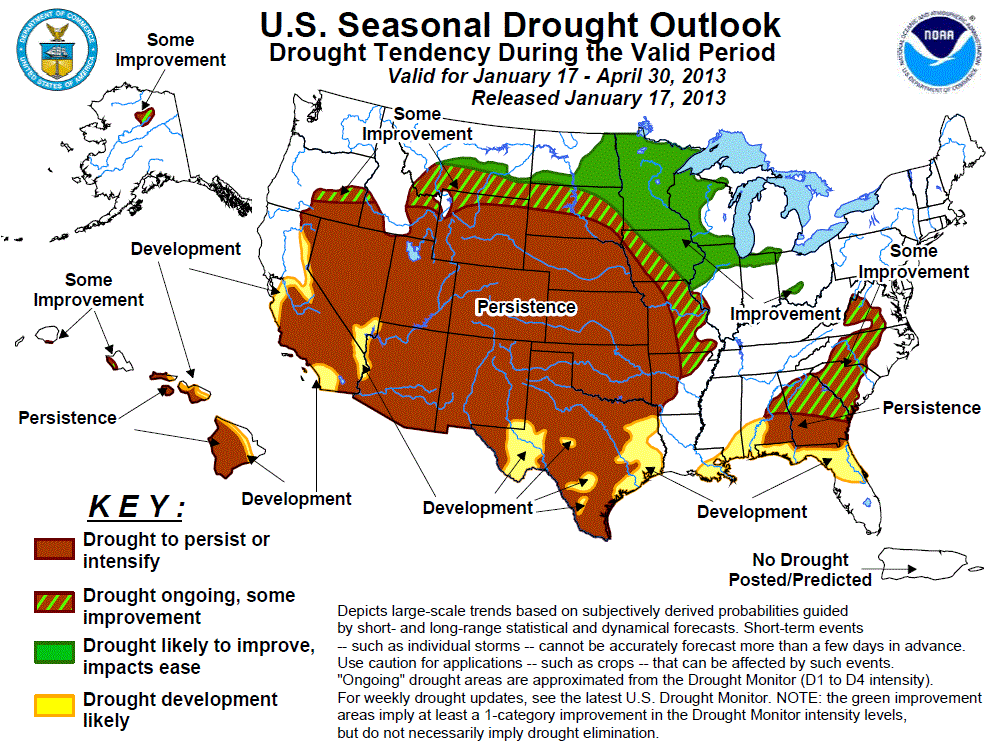
Latest Seasonal Assessment -
Since the beginning of 2013, drier and colder weather prevailed over the West after a relatively wet December. In the Great Basin and central
Rockies, 2-week temperature departures averaged 10 to 20 degrees F below normal. Farther east, however, a series of slow-moving cold fronts
embedded with surface lows brought surplus precipitation to the southern Plains (eastern New Mexico and Texas), parts of the central Plains
(western Oklahoma and central Kansas), and the lower Mississippi, Tennessee, and Ohio Valleys, providing some relief from the drought. Portions
of the northern Rockies and Plains and upper Midwest also saw above normal year-to-date precipitation. Temperatures in the eastern half of the
Nation have quickly moderated after a cold start to the year. Elsewhere, mostly dry weather exacerbated drought conditions in the Southwest,
central Plains and western Corn Belt, and eastern Gulf and southern Atlantic Coasts. In Hawaii, shower activity has increased during the past 2
weeks, mostly falling on windward locations and northern islands.
During the upcoming three months, a much drier pattern is expected across the southern third of the Nation (from central California to the
eastern Gulf Coast). This limits the prospects for further drought improvements during the latter end of the wet season in California, Nevada,
and western Arizona, and in fact increases the probabilities for drought development and deterioration in the tri-State area. This also marks a
change from recent wet conditions in the southern Plains and western Gulf Coast as drought development and persistence is forecast for Texas by
the end of April. Similarly, drought development and persistence is possible in the eastern Gulf Coast States, but less likely further north.
In contrast, enhanced probabilities of surplus precipitation and subnormal temperatures across the northern U.S. (from the northern Rockies
eastward to the upper Midwest and into the western Corn Belt) increase the odds for drought improvement. Some improvement is possible across
the middle Mississippi Valley and the Piedmont, the latter area from wetness forecast for the rest of the month.
With odds favoring subnormal February and FMA rainfall, drought conditions should persist across the leeward sides of Hawaii’s southern islands
and possibly expand toward windward sides during the latter end of the winter rainy season. However, recent and forecasted short-term shower
activity across the northern islands had increased enough for some improvement in Kauai and Oahu. In northwestern Alaska, with the odds
favoring above-normal February precipitation, the Koyukuk Basin of Alaska was changed from persistence to some improvement in anticipation of
increasing its snow pack for late spring melting.
|
|
Tools used in the U.S. Drought Outlook (USDO) included the official CPC temperature and precipitation outlooks for February 2013, the long
lead forecast for February to April 2013, various short- and medium-range forecasts and models such
as the 6-10 day and 8-14 day forecasts, the NAEFS precipitation outlooks, the soil moisture tools
based on the Constructed Analog on Soil (CAS) moisture, dynamical models (CFSv2, NMME, and IMME), the 384-hour total precipitation
forecasts from several runs of the GFS, the four-month Palmer drought termination and amelioration probabilities, climatology, and initial
conditions. We are currently in ENSO Neutral conditions as of this forecast release date.
During the previous two weeks, widespread heavy rainfall fell along the western edge of the long term drought areas of the Southeast and
Piedmont, with two to four times the normal precipitation occurring from Louisiana northeastward into southwestern Virginia during a
climatologically wet period of the year. The rains increased stream flows and brought some drought relief along the western edge of the
Southeastern drought area and into southern Virginia. During the next few days, additional precipitation is expected to fall on most of
the core drought areas except the extreme southern sections. Then, the CPC week 2 outlooks put enhanced odds of below median rainfall for
the Southeast. The February outlook also tilts the odds towards below median precipitation, although mainly along the western half of the
Gulf Coast, while the seasonal forecast has below normal precipitation along the entire Gulf Coast. Farther north, however, there is no
tilt either way for precipitation. The latest runs of the CFSv2 and NMME climate models indicate negative precipitation anomalies for the
southeastern U.S. through April. With an expected change from recent wetness to drier conditions, drought is likely to persist or develop
along the central and eastern Gulf Coast, but some improvement is possible farther north in the Piedmont region.
Forecast confidence for the Southeast and Piedmont is moderate.
Widespread precipitation during the latter half of December and early January boosted moisture and improved drought conditions across
parts of Texas. Additional precipitation is expected during the next few days, but mainly confined to eastern sections of Texas.
Unfortunately, a pattern change in the CPC 6-10 and 8-14 day outlooks tilt the odds in favor of below median precipitation. The CPC
February and FMA outlooks and the CFSv2 and NMME models all indicate enhanced chances of below median precipitation for the southern
Plains, and the seasonal outlooks indicates favorable odds for above normal temperatures. Although current wet conditions have warranted
improvements to the drought in Texas, this latest guidance points to a return of drier conditions. Accordingly, drought should persist or
develop in Texas and the southern Plains.
Forecast confidence for the southern Plains is moderate.
During early January, an upper-air system armed with moisture brought welcome surplus precipitation to western sections of Texas and
Oklahoma and central Kansas. Additional precipitation fell on portions of Montana, Wyoming, and South Dakota, but subnormal precipitation
was observed elsewhere across the Plains states. Streams have frozen for the winter across the Dakotas and eastern Montana under a decent
snow pack. The February through April period is climatologically dry, but normals rapidly increase in the early spring (April) and peak in
the late spring and summer months in the Plains. Only light precipitation is expected in the northern Plains during the upcoming week. The
CPC 6-10 and 8-14 day outlooks tilt the odds towards near to above median precipitation across the northern Plains, and towards below
median precipitation in the central Plains. The CPC February and FMA outlooks maintain the enhanced odds of above median precipitation for
the northern Plains, while the central Plains keeps equal chances in both outlooks. Based on the favorable odds of above normal
precipitation and subnormal temperatures, improvement or some improvement is expected in the northern and north-central Plains, especially
if a deep snowpack lingers into the spring. Farther south, however, relatively dry climatology, dry short and medium term forecasts,
current extreme to exceptional drought conditions, and no monthly and seasonal precipitation tilt either way calls for drought persistence
in the central Plains.
Forecast confidence for the central and northern Plains is moderate.
As of mid-January, snow cover was patchy and shallow across the Midwest, with mild and rainy weather melting away much of the snow from 2
weeks ago. Snowpack depth did increase toward the north, especially in Minnesota and northern Wisconsin. Many streams across Minnesota and
parts of Wisconsin have frozen for the winter. During the past 2 weeks, precipitation was greatest in Illinois, Indiana, and Michigan, and
in northern Minnesota, but relatively dry in Iowa. Light precipitation is expected across the Great Lakes region during the upcoming week,
with locally higher amounts due to lake effect snowfall. During the week 2 period, somewhat enhanced chances for above median
precipitation are expected across the upper Midwest and Great Lakes region, while the CPC February outlook tilts the odds towards wet and
cold anomalies across the northern Plains and upper Midwest, while the FMA outlook favors wet conditions from the northern Plains
southeastward into the Ohio Valley. Based on this guidance, further improvement or some improvement is expected.
Forecast confidence for the Midwest is moderate to high.
After a wet November and December, much colder and drier conditions enveloped the West, with temperatures well below normal in the Great
Basin and central Rockies. The CFSv2 and NMME forecasts have consistently predicted negative precipitation anomalies across portions of the
western U.S. during the winter months, but these forecasts failed to verify as repeated late autumn and early winter storm systems pushed
ashore in California and Oregon. However, the phase of the PNA became positive during the last week of December and brought an end to the
stormy pattern. Dry weather should persist the next several days, but storm systems should return to the Northwest by the middle of next
week. By then, light precipitation is expected along the Washington and Oregon Coast, while dry conditions are forecast for the Sierra
Nevada and the Southwest. The CPC 6-10 day, February, and FMA outlooks all predict enhanced chances of below median precipitation for
California and the Four Corners states, plus above normal temperatures during February. February is the wettest month of the year
climatologically for the Central Valley of California, so significant negative precipitation anomalies during this period have a high
impact on drought conditions in the spring. Based on the dry guidance and current conditions, drought persistence is expected. Additional
development was limited to current areas categorized as D0 (abnormally dry) in the most recent U.S. Drought Monitor due to the incipient
wetness in the region.
Forecast confidence for the West is moderate to high.
Continued early January showers across Kauai, Oahu, and the eastern Big Island further improved drought conditions, with very little
drought (D1) left on Kauai or Oahu according to the January 15 U.S. Drought Monitor. However, the CPC February and FMA outlooks for
Hawaii both tilt the odds toward below median precipitation. And since the late winter and early spring months are climatologically wet in
Hawaii, large deficits would accumulate if rainfall was subnormal. Based on these outlooks, climatology, and current conditions,
persistence and some development is expected across the southern islands where drought conditions are worse. Where drought conditions are
not as severe (Kauai and Oahu), some improvement is still possible across the northern islands.
Forecast confidence for Hawaii is moderate.
Persistent dryness and low snowpack promoted drought development across the Koyukuk Basin of north-central Alaska. The CPC February
monthly outlook, however, tilts the odds towards above median precipitation in northwestern Alaska. With this outlook extending to the end
of April, some benefits from additional snowfall may be realized with the spring melt. Therefore, some improvement may be expected by
April 30.
Forecast confidence for Alaska is moderate.
|


