|
Latest Seasonal Assessment -
During the past two weeks (since May 2), unseasonably cold air (temperatures averaging 6 to 10 deg F below normal) persisted in the middle
third of the Nation while the Far West, eastern Great Lakes region, and New England recorded above normal readings. Excess precipitation fell on
most of the eastern half of the Nation and westward into the central Rockies, Great Basin, and Sierra Nevada. The heaviest rains (more than 6
inches) fell along the central Gulf and southern Atlantic Coasts and on western North Carolina. The combination of the cold air and ample
moisture produced late-season, record-breaking May snows in Colorado, parts of the central High Plains, and portions of the Midwest.
In contrast, drier conditions were observed in New England and the lower Great Lakes region, the northern and south-central Plains, the
Northwest, and Southwest. Meanwhile, ENSO-neutral conditions persisted across the tropical Atlantic, with most models forecasting no major
changes for later this year.
During the first week, a slow-moving cold front in the Plains and associated waves of low pressure dropped ample precipitation on the
Mississippi Valley into the Southeast, and eventually on the mid-Atlantic. Cold air dove southward out of Canada into the middle of the country
and to the Gulf, producing accumulating snows as far south as northwestern Arkansas. Heavy showers and thunderstorms inundated some locations
in southern parts of Louisiana, Mississippi, and Alabama and northeastern Florida with over 10 inches of rain. In the West, dry and hot Santa
Ana winds aided the huge Spring wild fire in the southern California coastal mountains. By week 2, temperatures moderated in the West as
humidity levels rose and some scattered showers fell, aiding fire fighters in their battle to control the Spring blaze. Farther east, after a
cold start, temperatures quickly rose into the 90’s in the Midwest while temperatures near freezing chilled the mid-Atlantic. Additional light
to moderate precipitation fell on parts of the southern and central Plains, Midwest, lower Delta, and New England. Cold and wet weather
prevailed in southern and northern sections of Alaska while showers have increased in coverage and intensity in the northern islands of Hawaii
(Kauai and Oahu), but less so in the southern islands.
Year-to-date precipitation (to May 13) has been subnormal in much of the West, northern and southern Plains, New England, eastern North
Carolina, and west-central Florida. The greatest deficits (more than 12 inches) have accumulated along the Washington, Oregon, and California
coasts, and in the Cascade and Sierra Nevada Mountains. Deficiencies exceeding 4 inches were found in New England, coastal North Carolina,
west-central Florida, and parts of the (Texas) Red River Valley. In contrast, surplus precipitation has fallen on the central Great Plains, the
Mississippi, Tennessee, and Ohio Valleys, the Southeast, and lower mid-Atlantic. In a sharp contrast to last year at this time, year-to-date
temperatures have averaged below normal across most of the lower 48 States, with slightly above normal readings limited to northern New England
and parts of California.
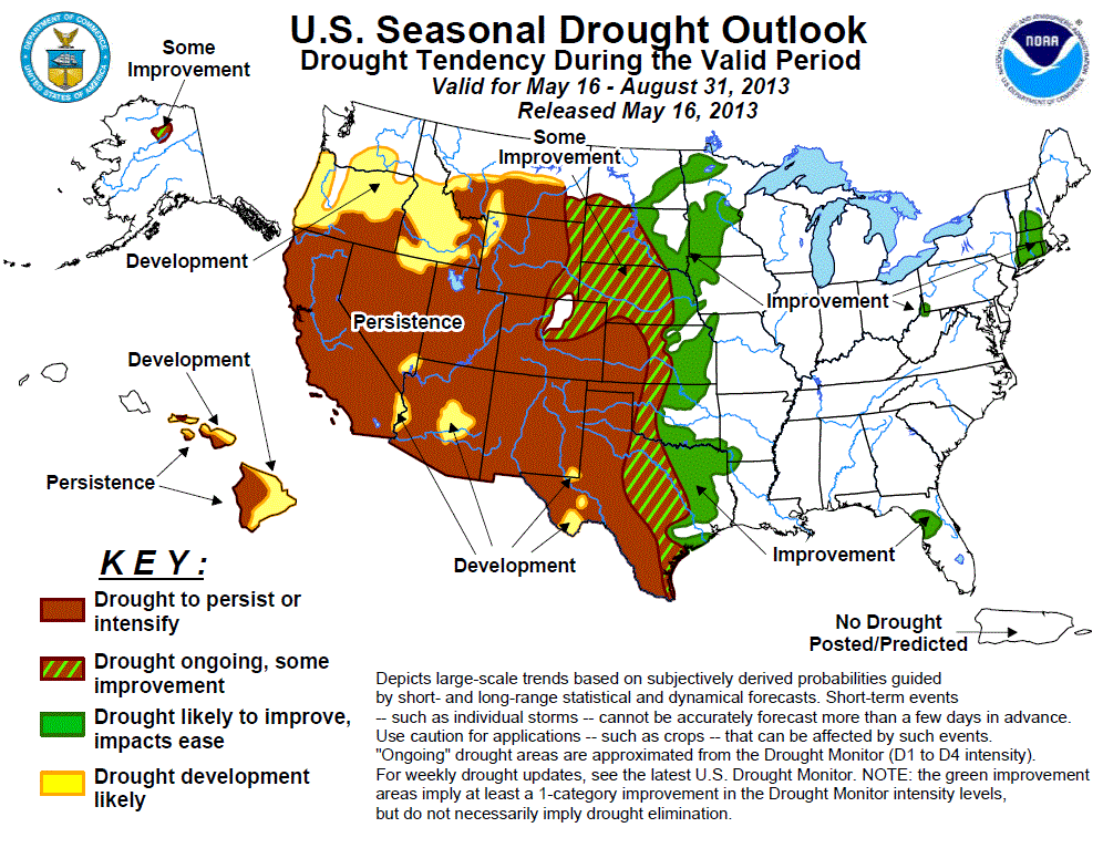
Accordingly, drought expansion has occurred over the past 2 weeks in the West, Southwest, and Northeast. In contrast, improvements were made
along the eastern edges of the main drought area in the Nation’s midsection, and in the Southeast. The worst conditions (D3 to D4) have
stubbornly persisted in the southern and central High Plains.
The monthly temperature and precipitation outlooks for June (released May 16) favor below median rainfall in the Far West and High Plains, with
equal chances elsewhere, including Alaska. A tilt toward above-median June temperatures were forecast for most of the western half of the U.S.,
with the best chances for above normal readings in the southern Rockies and High Plains. Some of the dynamical models hinted at cool and wet
June in the East, but they were not consistent and strong enough to be included in the monthly outlooks.
The seasonal temperature and precipitation outlooks are somewhat similar to the monthly outlooks, with odds for below median rainfall in the
Northwest and south-central High Plains. In contrast, a small area of above median rainfall was drawn along the central Gulf Coast and in
southeastern Alaska. Above median temperatures are also favored for most of the West, with the highest odds in the southern Rockies and High
Plains. In addition, the chances for above median warmth extended eastward along the Atlantic Coast, with slightly higher odds centered over the
Northeast. For the southwestern summer monsoon, a slight tilt toward below median rains was indicated in eastern areas (e.g. New Mexico and west
Texas).
Although CPC odds favored subnormal June and JJA rainfall, rainfall intensity and coverage increased the past several weeks across Hawaii,
especially on Kauai and Oahu and the windward side of the central islands, reducing drought on Oahu and Molokai. However, with the normal wet
season tapering off and the southern islands observing subnormal March and April rains, persistence remained on the leeward sides of Maui and
the Big Island, with development possible on their windward sides. In Alaska, the Koyukuk Basin of north-central Alaska was left as some
improvement with no tilt in odds either way (e.g. equal chances) for June and JJA precipitation.
|
|
Tools used in the U.S. Drought Outlook (USDO) included the official CPC temperature and precipitation outlooks for
June 2013 (released May 16), the long lead forecast for June to August 2013 (released May 16),
various short- and medium-range forecasts and models such as the 5-day HPC precipitation totals,
6-10 day and 8-14 day forecasts, the NAEFS precipitation outlooks, the soil moisture tools based on
the Constructed Analog on Soil (CAS) moisture, dynamical models (CFSv2, NMME, and IMME), the 384-hour total precipitation forecasts from
several runs of the GFS, the four-month Palmer drought termination and amelioration probabilities, climatology, and initial conditions. We
are currently in ENSO Neutral conditions as of this forecast release date.
During the previous two weeks, widespread heavy rain (3 to 6 inches, locally to 12 inches) fell on much of the central Gulf and southern
Atlantic Coast areas northward into the central Appalachians, with 2 to 8 times the normal precipitation occurring in southern sections of
Louisiana, Mississippi, and Alabama, and throughout most of Florida, Georgia, western Carolinas, western Virginia, and Maryland. The rains
greatly increased stream flows and brought drought relief in much of the region. During the next week, light to moderate rains are expected
to fall on the remaining small D1 areas, with high odds for above median precipitation in New England for days 6-10 and 8-14. The June and
JJA precipitation outlooks have equal chances for the Atlantic Coast, but some of the latest runs of the CFSv2 and NMME climate models
indicate positive precipitation anomalies for the southeastern U.S. through August. With a trend for wetness in the Southeast since
February, the Atlantic and Caribbean hurricane season normally commencing soon, and the peak rainy season for Florida from late spring
through early fall, the small pockets of drought along the East Coast are likely to vanish by the end of August.
Forecast confidence for the Atlantic Coast (Florida to New England) is moderate to high.
A deep winter and early spring snowpack, along with ideal conditions for slow melting (subnormal temperatures), plus above normal
precipitation during 2013, has allowed for excellent infiltration of moisture into the top and sub soils of most Midwestern locations. In
fact, too much rainfall has led to flooding and saturated soils in parts of the upper and middle Mississippi Valleys. During the past two
weeks, surplus precipitation (including heavy snows) fell on eastern Nebraska, Iowa, southeastern Minnesota, Wisconsin, UP of Michigan,
Illinois, and eastern Missouri, but it was relatively dry in Indiana, Ohio, lower Michigan, and most of Minnesota. Heavy precipitation is
expected across the upper Midwest and Ohio Valley during the next 5-days, with good odds for above median precipitation during days 6-10
and week 2 in the Great Lakes region. The CPC June and JJA precipitation outlooks have equal chances in the Midwest, although some June
dynamical models hint at positive precipitation anomalies here. Based on a persistently wet trend this year, along with short and
medium-term guidance of surplus precipitation, further improvement or some improvement is expected.
Forecast confidence for the Midwest is moderate to high.
The northern Plains (eastern Montana and North Dakota) received above normal precipitation late in 2012, but has since received subnormal
2013 amounts. In contrast, the opposite has occurred in the remainder of the region (South Dakota, Nebraska, and Kansas) where late 2012
was very dry, but near to above normal precipitation has fallen during 2013. Climatologically, the northern and central Plains
precipitation rapidly increases in the early spring (April) and peaks in the early summer before rapidly decreasing by the fall. As a
result, this is a critical time for the Plains to receive significant amounts in order to diminish the large deficits (5 to 15 inches)
accumulated last year. Fortunately, the HPC 5-day precipitation calls for widespread, moderate to heavy rains (1 to 2.5 inches) in the
northern half of the Plains and upper Midwest. Likewise, the CPC 6-10 day outlook tilts the odds towards above median precipitation across
the northern third of the Plains. The CPC June and JJA outlooks, however, forecast enhanced odds of below median precipitation and above
median temperatures for the central High Plains while keeping the northern third of the Plains at equal chances. Based on the favorable
odds of above normal precipitation in the short term and a normally wet summer climatology - but only equal chances for June and JJA (with
drier and warmer odds further south), last year’s large deficits still affecting the subsoil moisture and hydrology, and increasing summer
temperatures and evaporative rates, only some spotty improvement is expected in the northern half of the Plains.
Forecast confidence for the northern half of the Plains is moderate.
During the first five months of 2013, surplus precipitation and subnormal temperatures have brought drought improvement or alleviation to
parts of eastern Kansas, eastern Oklahoma, and northeastern Texas. Just to the west, however, much drier weather this year has maintained
or worsened D3 and D4 conditions in western sections of Texas, Oklahoma, and Kansas. Similar to the climatology of the northern Plains, the
southern Plains also receives the bulk of their annual precipitation during the summer months, although the rains normally start later and
linger into the early fall months (e.g. New Mexico’s wettest 3-months are JAS). After experiencing the 9th and 14th driest JAS on record
the past two years, New Mexico needs a wet JAS. Therefore, this starts a crucial period for badly-needed rains in the southern Plains and
the southwestern summer monsoon. Unfortunately, the short, medium, and long-term forecasts are not favorable for drought improvement,
especially in western sections. Light to moderate rains are forecast for eastern portions (Great Plains) of Texas, Oklahoma, and Kansas
during the next 5 days, but little or no rains are expected in the southern High Plains. The CPC 6-10 and 8-14 day outlooks tilt the odds
in favor of below median precipitation, while the CPC June and JJA outlooks both indicate enhanced chances of below median precipitation
for the southern High Plains. Furthermore, monthly and seasonal temperatures strongly tilt toward above normal values. Accordingly, with
most indicators and tools pointing toward below median precipitation and above median temperatures at all time periods, particularly in
western regions, drought is expected to persist or develop in the few areas not yet in drought. The exception to this is improvement or
some improvement in far eastern sections of Texas, Oklahoma, and Kansas where favorable 2013 weather has already brought some drought
relief.
Forecast confidence for the southern half of the Plains is moderate.
In the West, after a great start to the 2012-13 Water Year (a very wet November and December), near-record and record dryness enveloped the
region during January-April. As a result, the memory of the wet start to the Water Year faded away, gradually replaced by impacts from the
2013 dryness. In addition, the start of the normally dry summer and fall months has commenced, making it highly unlikely that any
substantial precipitation will occur during the next several months. Not surprisingly, the HPC 5-day, CPC 6-10 and 8-14 day, June and JJA
outlooks all predict equal chances (arid climatology) or enhanced chances of below median precipitation for California and the Southwest.
For the southwest summer monsoon, the tools were not in full consensus in western areas (e.g. southeastern California, Arizona, southern
Nevada, Utah), hence equal chances. In the eastern areas (e.g. New Mexico, west Texas, southeastern Colorado), however, the CPC June and
JJA outlooks both indicate enhanced chances of below median precipitation and above median temperatures for the southern High Plains. Based
on ongoing impacts from the record dry January-April, normally dry summer climatology, and monthly and seasonal outlooks, drought
persistence is expected in much of the West, with development possible in the Northwest (e.g. Oregon, Idaho, western Wyoming, southwestern
Montana). Development was limited to current areas categorized as D0 (abnormally dry) in the most recent U.S. Drought Monitor.
Forecast confidence for the West is high, moderate in the Southwest.
An increase in the intensity and coverage of April showers across Kauai and Oahu, and recent rains on the windward side of Molokai brought
improvement of drought conditions. Drought was erased from Kauai and Oahu, but unfortunately April and early May rains were less widespread
and lighter farther south. With the CPC June and JJA outlooks for Hawaii both tilting the odds toward below median precipitation, the
rainy season nearing an end, and a dry late spring on the southern islands, the drought outlook was fairly straightforward. Accordingly,
persistence is forecast for the leeward sides of the central and southern islands, with development on the windward sides.
Forecast confidence for Hawaii is moderate to high.
Low snowpack and snow water content (about 75 percent of normal on May 1) for the Koyukuk Basin of north-central Alaska maintained D1
conditions as of the May 7 U.S. Drought Monitor. The CPC June and JJA outlooks have no tilt for precipitation (equal chances) here, but
the basin may benefit from late spring snowfall and the resulting summer melt. In addition, the summer months are normally the wettest time
of the year in north-central Alaska, so the climatology is favorable for producing decent rain totals. Therefore, some improvement may be
expected by the end of August.
Forecast confidence for Alaska is moderate.
|


