|
| |
 |
| |
|
March - May 2013
|
| |
|
Outlook Graphic: GIF PDF 
|
| |
|
Latest Seasonal Assessment -
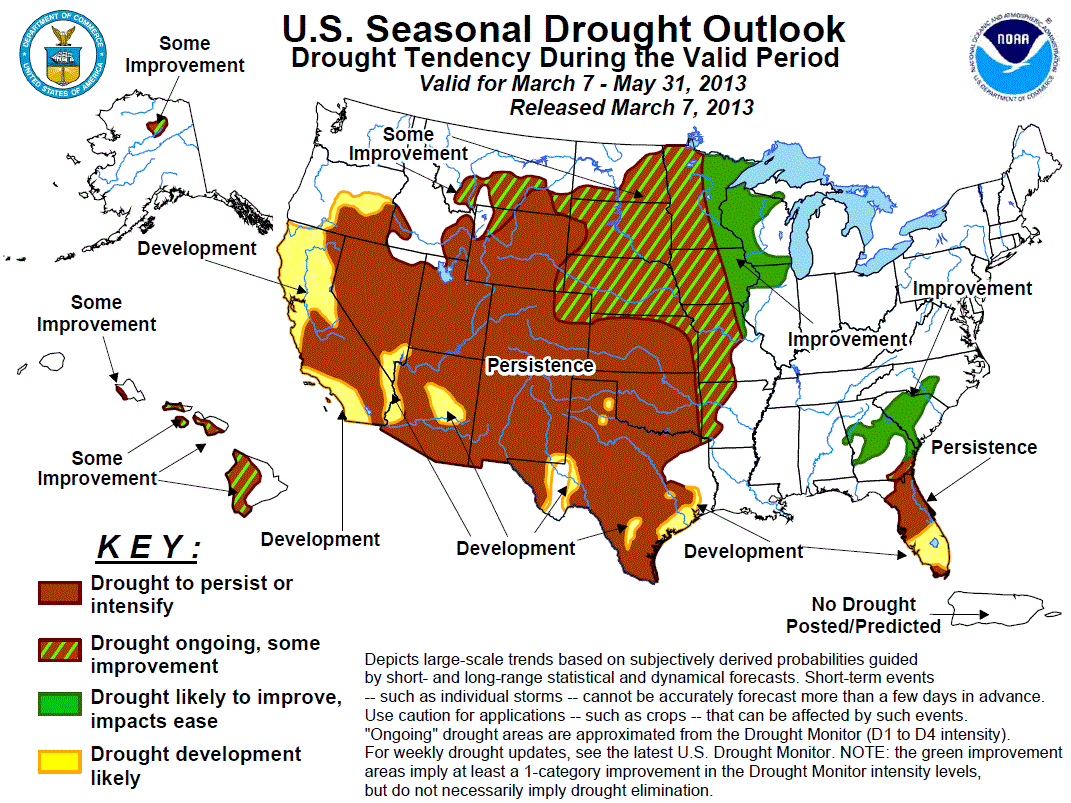
Climatologically, spring (March - May) brings changing precipitation patterns to much of the country. In California and the
Far West, the wet season is winding down during March, and by May precipitation is sparse. In contrast, precipitation normals
increase across the northern and central Plains, the southern High Plains, and northern and eastern parts of the Rockies.
Historically, these areas receive 3 to 7 percent of their annual precipitation during March while 11 to 19 percent falls in
May.
Because patterns are in flux, few locations are markedly wet or dry for March - May as a whole compared to other times of the
year. Distributed evenly, 25 percent of annual precipitation would fall during a 3-month period. In the north-central Rockies
and central Plains, 30 to 40 percent of yearly precipitation falls on average during spring, mainly due to the wet May.
Meanwhile, spring historically delivers less than 20 percent of the annual total to the Florida peninsula and the southern
Rockies. Southern sections of Arizona and New Mexico receive only about 2 percent of their annual total during spring.
These factors weighed heavily on the updated Drought Outlook for March - May 2013, as they had in the initial outlook released
in mid-February. Regarding the large area of extreme to exceptional drought in the Nation's midsection, precipitation normals
increase significantly later in the forecast period, and precipitation then will be the primary driving factor behind the
Drought Monitor depiction for the end of May. Still, with significant precipitation forecast in parts of the central and upper
Plains through mid-March - on top of the rain and snow observed in late February - it seems likely that at least some surface
moisture increases will be observed. Therefore, some improvement was forecast for much of the northern half of the Plains. With
only one month of the wet season included in this forecast period, more substantial, longer-term improvement is unlikely.
Additionally, the 3-month outlook favors below-median precipitation across roughly the southwest half of the extreme to
exceptional drought area. There are equal chances for wetness and dryness in the rest of the area.
From the Rockies westward, precipitation forecasts for time periods ranging from the next 5 days to the next 3 months
generally favor dryness for central and southern sections of the drought region. Thus, persistence and areas of development
are again forecast for most areas from the Rockies westward to the Pacific Ocean. Limited improvement is anticipated along the
northern tier near the Montana/Wyoming border, where dryness is not as universally indicated.
Off to the East, there are enhanced chances for above-normal spring precipitation from the Mississippi Valley eastward into
the Great Lakes region, and at least light to moderate precipitation is forecast during the near-term. Thus, drought
conditions are expected to improve.
In the Southeast, there has been a trend toward heavier rainfall and improving drought to the north and west of the Florida
Peninsula, and this is expected to continue, at least in the near-term. Between 10 and 20 inches of rain fell on this region
between early February and early March. One- and three-month outlooks lean dry, but given the amounts of rain observed and the
additional precipitation expected around mid-March, drought is expected to be less intense by the end of May than it is
currently. However, it will take time for any increased rainfall to chip away at the large moisture deficits that have
accumulated over the course of this multi-year drought. Farther south, heavy precipitation has missed the Florida Peninsula,
where short-term dryness has been observed. The mid-March and March - May outlooks favor less rainfall than usual. Given the
moisture shortfalls already in place, and that spring is a dry time of year in the region in any case, drought is forecast to
persist, expanding to cover the entire Peninsula by the end of May.
Elsewhere, mountain snowpack was only 25 to 50 percent of normal across the drought area in north-central Alaska. Limited
improvement is anticipated there over the next 3 months. Finally, drought covers western and some central sections of the
individual Hawaiian Islands from Oahu southeastward through the Big Island. Some improvement is anticipated over the course of
meteorological spring.
|
| |
|
Discussion for the Seasonal Drought Outlook
|
| |
|
Tools used in the U.S. Drought Outlook (USDO) included the official CPC temperature and precipitation outlooks for March
2013 and March through May 2013 (released Feb. 21), various short- and medium-range forecasts and
models such as the 5-day and experimental 7-day HPC precipitation totals (released Feb. 20), 6-10 day and 8-14 day forecasts
(released Feb. 20), the NAEFS precipitation outlooks, the soil moisture tools based
on the Constructed Analog on Soil (CAS) moisture, dynamical models (CFSv2, NMME, and IMME), the 384-hour total
precipitation forecasts from several runs of the GFS, the four-month Palmer drought termination and amelioration
probabilities, climatology, and initial conditions. We are currently in ENSO Neutral conditions as of this forecast
release date.
Across the interior Southeast, north of the Florida Peninsula, heavy rains have fallen since late February, with 10 to 20
inches reported in a stripe across the western Florida Panhandle and much of central and southern Georgia. The March -
May 2013 precipitation outlook favors below normal precipitation in this same area while the updated March outlook is
non-committal. Drought improvement is forecast because of the magnitude of the rainfall already observed and because
relative confidence in the long-term outlooks is inherently relatively low. Still, marked dryness during the last half of
the period could counteract recent rains, and this seems quite possible (though not likely) in light of the dry 3-month
precipitation outlook.
Forecast confidence in the interior Southeast is moderate.
Farther south, the heaviest rains missed the Florida Peninsula. The three-month precipitation outlook favors below-median
precipitation as it does farther north, but with higher probabilities. Shorter-term, below-median rainfall is expected,
and this is a dry time of year there - only 15 to 20 percent of annual rainfall is recorded during March - May typically.
This all implies continued surface moisture depletion, and the ongoing short-term drought should persist and expand
through the end of May, with drought anticipated along the entire Peninsula by then.
Forecast confidence along the Florida Peninsula is high.
Drought is expected to improve at least somewhat across the northern half of the Mississippi Valley and the western Great
Lakes region. Specifically, some improvement is forecast across most of Missouri and the central and western sections of
Iowa and Minnesota, with more marked improvement anticipated farther east. Odds favor at least moderate precipitation
through mid-March in the 8 to 14 day outlook, and the 3-month precipitation outlook favors above-median precipitation
for most of the region, except along the western tier. Only some improvement was forecast in this area where the 3-month
outlook did not favor surplus rainfall, with more robust improvement depicted where there was a tilt of the odds toward
wetness in the three month outlook.
Forecast confidence in the Mississippi Valley and western Great Lakes is moderate.
Drought is expected to persist and expand across the southern half of the Plains, all but the northern tier of the
Rockies, the Intermountain West, and the Far West. This includes those parts of the broad extreme to exceptional drought
area that lie south and west of Nebraska, where forecasts on most time scales favor below-median precipitation.
Areas from Nebraska to the north and northwest can expect limited improvement. Moderate to heavy precipitation for this
time of year is expected in Nebraska and surrounding areas on top of the significant precipitation observed recently.
Some improvement was forecast farther north and northwest - in much of the Dakotas and in some areas near the
Montana/Wyoming border - for one or more of the following reasons: Moisture deficits of shorter duration and/or smaller
magnitude than farther south; near-normal precipitation since the start of the water year (Oct. 1, 2012); near-average
mountain snowpack; an unremarkable Surface Water Supply Index (SWSI); and/or near-normal summer streamflow forecasts. All
of these factors make it easier to mitigate impacts.
However, the majority of the large area of drought can expect conditions to persist, with no lasting, tangible improvement
anticipated at least through the end of May. Even in the central Plains, normals are fairly low until May, and any
significant, long-standing improvement is unlikely before then. Drought is expected to expand into most areas not
currently in drought along the southern tier of the country from central Texas through southwestern California. Also,
drought is expected to expand significantly across central and northern California and adjacent Oregon. The forecast
expansion in the west-central Pacific Coast was motivated by a markedly dry February and forecasts for continued
below-median precipitation on most time scales ranging from 5 days to 3 months. The 3-month precipitation outlook for
northern and central California indicates chances exceeding 50 percent that spring precipitation totals will rank among
the lower one-third of historic occurrences.
The one significant wild card through the Plains and adjacent Rockies is May - a wet month with sizeable precipitation
normals as mentioned already. Moisture deficits could rise or fall quickly once the month gets underway if precipitation
is significantly above or below normal.
For the large area of drought from the Plains westward to the Pacific Coast, forecast confidence is moderate to high,
with less certainty along northern and eastern parts of the region, where the monthly and 3-month outlooks do not favor
drier than normal conditions as they do elsewhere.
Mountain snowpack was only 25 to 50 percent of normal on February 1, 2013 across the drought area in north-central Alaska.
Limited improvement is anticipated there over the next 3 months.
Finally, drought covers western and some central sections of the individual Hawaiian Islands from Oahu southeastward
through the Big Island. Some drought improvement is expected throughout these areas.
Forecast confidence in Alaska and Hawaii is moderate.
|
|


