|
Latest Seasonal Assessment -
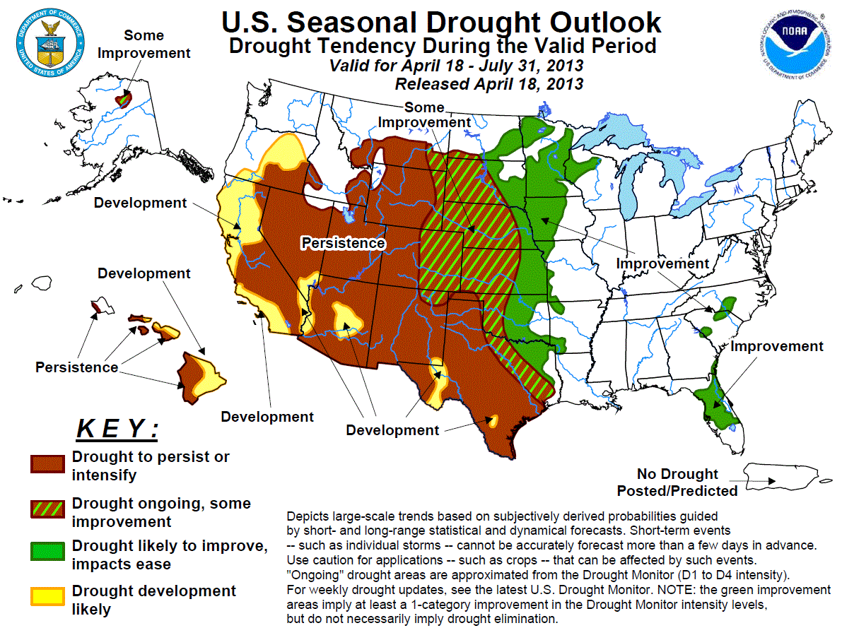
The drought outlook for April 18 – July 31, 2013 is based primarily on short-, medium-, and long-range forecasts, initial conditions, and climatology. During the past two
months, major improvement occurred across Georgia and South Carolina where additional improvement is expected. Improvement is also forecast for the Florida peninsula. The
duration of the drought across south Florida is expected to be short-lived as the rainy season typically begins by the end of May. A repeat of last summer's
“flash drought” (both in spatial coverage and duration) across the Corn Belt is not expected at this time. However, rapidly developing flash droughts are notoriously
difficult to predict well in advance. Improvement is forecast across eastern Kansas, eastern Oklahoma, and northeast Texas, but prospects for drought improvement decrease
farther southwest across the southern High Plains and south Texas. Some improvement is expected across the intense drought areas of the northern/central Plains, while
improvement is more likely across the upper Mississippi Valley. Drought is forecast to persist for much of the West and expand across northern California and southern
Oregon. Some improvement is expected for the drought area across northern Alaska, while areas of persistence and development of drought are anticipated for the Hawaiian
Islands.
|
|
Tools used in the U.S. Drought Outlook (USDO) included the CPC temperature and precipitation outlooks for May 2013 and May through July 2013,
various short- and medium-range forecasts and models such as the 5-day and experimental 7-day WPC precipitation
totals (released April 17), 6-10 day and 8-14 day forecasts (released April 17), the NAEFS precipitation outlooks, the soil
moisture tools based on the Constructed Analog on Soil (CAS) moisture, dynamical models (CFSv2, NMME, and IMME), the 384-hour total
precipitation forecasts from several runs of the GFS, the four-month Palmer drought termination and amelioration probabilities, climatology, and initial conditions.
Frequent rainfall during February and March resulted in major drought improvement across Georgia and South Carolina. The U.S. Drought Monitor released on April 9th
indicated that only 4 percent of Georgia was covered by drought. Nearly 90 percent of Georgia was depicted with drought at the beginning of 2013. Levels on Lake
Lanier have recovered to bank full. Drought improvement is likely to continue across Georgia, South Carolina and North Carolina with additional rainfall during the
next two weeks.
Forecast confidence for Georgia and the Carolinas is high.
Improvement is forecast for the Florida peninsula where near- to above-median rainfall amounts are expected over the next two weeks. The CPC monthly outlook for May
favors Equal Chances (EC) of below, near, and above median precipitation across the Florida peninsula. As of April 16, the level of Lake Okeechobee is at 13.6 feet
which is slightly below average for the middle of April. With observed rainfall amounts of 1-3 inches over the past two weeks, the area of drought over south Florida
was removed. In addition, with the traditional onset of Florida's rainy season only 5-6 weeks away, it is highly unlikely for drought to develop in such a short
period of time.
Forecast confidence for Florida is moderate.
During the past two weeks, most of Texas received light rain (a half-inch or less), with the exception of parts of northern, far eastern, and south-central Texas,
where anywhere from 1-3 inches of precipitation fell. The WPC precipitation forecast for the ensuing 7-day period calls for little if any rainfall across West Texas,
light rain (0.5-inch or less) over southern Texas, and moderate precipitation (0.5-1.5 inches) for the northeast quarter of the state. Heavy precipitation
(3-5 inches) is anticipated over eastern portions of both Kansas and Oklahoma, which will continue to ameliorate drought conditions over these areas. The MJJ 2013
seasonal outlook depicts slightly enhanced odds of below median precipitation across the southern High Plains, and EC elsewhere.
Forecast confidence for the southern half of the Plains is moderate.
The seasonal drought outlook for the northern Plains shows a broad, west-to-east gradient of Persistence, Some Improvement, and expected Improvement. Defining where
the boundaries lie between these categories is based on a compromise between various competing factors. In the northern High Plains, drought Persistence appears to be
the best bet. Although portions of southeastern Montana have received beneficial precipitation over the past week, local gauges indicate that much of the area is
still running well behind for this Water Year to Date (WYTD, starting from October 1 of last year), and this is in addition to the deficit which mounted during the
previous Water Year. The MJJ precipitation outlook shows elevated odds for below median precipitation in this region, and EC for the remainder of the northern Great
Plains. A competing factor for both this area and adjacent portions of the northern Plains is the climatological observation that MJJ is typically a wet time of the
year for this area, when a bit more than half of their annual precipitation typically falls. The area of Some Improvement appears to be best suited for far eastern
Montana, the western Dakotas and western Nebraska, while the region of Improvement has been expanded westward to include the eastern Dakotas and eastern Nebraska. The
deepest snow is currently over North Dakota and the eastern half of South Dakota. Several days ago, a blizzard brought 17.3 inches of snow to Bismarck, which broke
multiple snowfall records, including most snowfall for any calendar day of the year (previous record of 15.5 inches was set on March 3, 1966), and the record April
snowfall of 21.5 inches (previous record was 18.7 inches set in April 1984).
Forecast confidence for the northern half of the Plains is low.
According to the National Operational Hydrologic Remote Sensing Center on April 17, snow-water equivalent values range from 2 to 6 inches across the upper
Mississippi Valley. Frozen soil has posed a significant problem for portions of this region, for it does not allow melting snow to percolate into the dry sub-soils.
Two uncertainties at this time include how effectively the soil can be recharged (with minimal loss from snow-melt runoff), and also the competing factors of
unseasonably cold weather with increasing solar angle as the spring season progresses. MJJ is a relatively wet time of year for the upper Mississippi Valley. The
6-10/8-14 Day outlooks from April 17 favor above median precipitation in this region. Due to these factors, improvement is expected across the upper Mississippi
Valley. The seasonal outlook for May-July calls for EC in this region. Consideration of these various factors leads to a tilt in the odds towards Improvement.
Forecast confidence for the upper Mississippi Valley is moderate.
Persistence is expected for western Colorado, most of New Mexico, Utah, Nevada, and Arizona due to below average snow-water equivalent values (generally at or
below 75 percent of normal) and below average stream flows forecast for spring and summer. Enhanced odds for below median precipitation and above normal
temperatures during MJJ also favor persistence. During the past few days, between 10 and 20 inches of snow have fallen across the Colorado Front Range and
adjacent foothills area between Denver and Cheyenne. This precipitation along with more anticipated in the short-term, as well as the lack of a dry signal
during MJJ lead to a forecast of some improvement across eastern Colorado and parts of northeast New Mexico.
Forecast confidence for Colorado, New Mexico, Utah, Nevada, and Arizona is moderate to high.
Similar to the interior Southwest, snow-water equivalent values are also below average across California and southern Oregon. Following a wet start to the
winter, unseasonably dry conditions affected these areas during the past three months. According to the U.S. Drought Monitor on April 16, abnormal dryness (DO)
covers northern California and parts of southern/eastern Oregon, and moderate drought (D1) conditions prevail across southeastern Oregon. Persistence and development
are favored for this region. Precipitation typically decreases rapidly later in the spring with little to no prospects for improvement after April.
Forecast confidence for California and southern Oregon is high.
Snow-water equivalent values are running close to average across the northern Rockies. Precipitation forecasts at most time scales favor Persistence of drought for
the northern Rockies and portions of the adjacent High Plains. However, forecast confidence is low, since about 50-55 percent of the annual precipitation for most of
Montana and Wyoming typically falls during May-July.
Forecast confidence for the northern Rockies is low.
Mountain snow-pack ranged from 55-90 percent of normal on April 17, 2013 across the drought area in north-central Alaska, which is comparable to that over the past
few weeks. Some improvement is forecast for this region.
Forecast confidence in Alaska is moderate.
Moderate to extreme drought covers western (leeward) sections of the individual Hawaiian Islands from Molokai southeastward through the Big Island. Persistence is
forecast for these leeward areas since odds for improvement decrease significantly during May and June. The windward slopes of these Islands have seen a substantial
reduction in trade wind shower activity, supporting the introduction of drought Development. Both Oahu and Kauai are doing well, having received some rainfall from
passing fronts, but these systems dissipate before reaching the eastern half of the Island Chain.
Forecast confidence in Hawaii is moderate.
|


