|
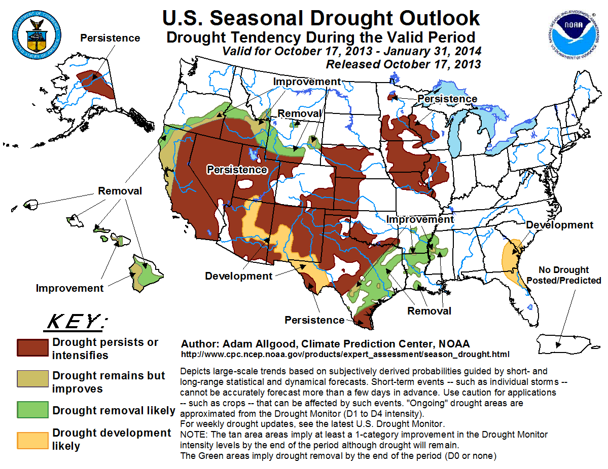
Tools used in the U.S. Seasonal Drought Outlook (USDO) included the official CPC temperature and precipitation outlooks for
November 2013, the long lead forecast for November 2013 through January 2014, various
short- and medium-range forecasts and models such as the 5-day and 7-day precipitation totals from the Weather Prediction
Center, 6-10 day and 8-14 day forecasts, the NAEFS precipitation outlooks, the soil moisture tools based on the Constructed
Analog on Soil (CAS) moisture, dynamical models (CFSv2, NMME, and IMME), the 384-hour total precipitation forecasts from several runs of the GFS, the four-month
Palmer drought termination and amelioration probabilities, climatology, and initial conditions.
The 30-day ACIS-based percent of normal precipitation values ranged between 25 and 75 percent of normal across the Atlantic coastal plain of South Carolina, Georgia,
and northern Florida. The current 28-day averaged stream flow values remain generally near normal and the region is not yet currently experiencing abnormally dry
conditions. Below normal precipitation is forecast for the upcoming 7-day period, however, with accumulations generally under an inch. During the remainder of
October, an amplified pattern is anticipated over the CONUS with deep, large scale troughing over the eastern seaboard. This mid-latitude setup would promote a
steering influence away from the Southeast for any tropical cyclones developing in the Caribbean. Beyond the second half of October, climatological Atlantic
tropical cyclone activity diminishes rapidly, and the suppressed phase of the MJO, if it remains coherent, will propagate over the western hemisphere, reducing the
chances for any late season development. Therefore, it seems that the chances for significant moisture due to tropical cyclone activity are reduced over the
southeastern U.S. Although the CPC November outlook maintains equal chances of below, near, or above-median precipitation along the southern Atlantic coast, the
seasonal outlook for November through January maintains probabilities above 40-percent for below-median precipitation. Therefore, drought development is possible for
portions of the southeastern Atlantic coastal plain, particularly across northeastern Florida, eastern Georgia, and southern South Carolina, where recent rainfall
deficits are the highest.
Forecast confidence for the southern Atlantic coastal plain is moderate.
A storm system brought widespread precipitation to the northern Plains and upper Midwest during the previous week, removing drought across the Dakotas and bringing
some improvement to Minnesota. Accumulations were smaller over the middle Mississippi Valley. Late autumn and winter are climatologically dry for the middle and
upper Mississippi Valley, with soils, streams, and lakes eventually freezing. Therefore, in the absence of well above normal precipitation, it is difficult to
realize significant drought improvements during this period. Additional light accumulations, generally under a half inch, are anticipated during the upcoming
7-days. The CPC 6-10 and 8-14 day outlooks indicate enhanced chances of above-median precipitation over Minnesota, with below-median precipitation more likely
across Missouri. The CPC monthly and seasonal outlooks both maintain equal chances for below, near, or above-median precipitation. Based on the time of year
climatology, persistence is forecasted for lingering drought areas in Missouri, Illinois, Minnesota, and Wisconsin.
Forecast confidence for the upper and middle Mississippi Valley is moderate.
During the previous 30 days, widespread rainfall overspread the lower Mississippi Valley, boosting moisture and bringing localized drought relief to parts of
Louisiana, Mississippi, and Arkansas. As a slow moving cold front progresses eastward over the Gulf Coast states, additional rainfall is expected over the areas of
lingering drought. The CPC 6-10 and 8-14 outlooks tilt the odds towards above-median rainfall, indicating a continuation of the wet pattern during the remainder of
October. The CPC official monthly and seasonal outlooks both maintain equal chances for below, near, or above-median precipitation. Climatological rainfall
increases during the winter months across the lower Mississippi Valley, as the mid-latitude storm track shifts southwards towards the Gulf Coast. Given the wet
short term forecast and climatology, drought improvement is anticipated over the lower Mississippi Valley.
Forecast confidence for the lower Mississippi Valley is high.
During the previous 30 days, widespread heavy rainfall fell across central, south-central, and eastern Texas, ameliorating drought conditions and causing flooding
along parts of the Rio Grande Valley. Rainfall was spottier across northern Texas, Oklahoma, and Kansas, while an early season winter storm brought heavier
accumulations to Nebraska. A slow moving cold front is bringing additional rainfall in the near term to eastern Texas. Late autumn and winter are climatologically
dry across the Plains, making significant reductions in drought during this period less likely. The CPC 6-10 and 8-14 day outlooks tilt the odds towards abnormal
wetness across the southern half of Texas, with abnormal dryness more likely over the remainder of the central and southern Plains. The CPC monthly outlook for
November indicates enhanced chances for below-median precipitation across the southern High Plains, and the seasonal outlook indicates enhanced chances for
below-median precipitation across much of Texas, western Oklahoma, and New Mexico. Based on the dry climatology and outlooks, therefore, drought persistence is
forecast for the central and southern Plains. Areas of development are possible across the Texas Panhandle and New Mexico. In contrast, the near term rainfall is
forecast to continue improving drought conditions across parts of central and eastern Texas, particularly in areas that have shallower drought conditions initially
due to recent rains.
Forecast confidence for the central and southern Plains is moderate.
An early season winter storm brought widespread heavy precipitation to the northern Rockies and adjacent Plains during the first half of October. This precipitation
eased drought conditions across Wyoming, although blizzard conditions caused considerable livestock losses in eastern Wyoming, South Dakota, and parts of Nebraska.
Additional light to moderate precipitation is forecast during the upcoming 7-day period, and the CPC 6-10 and 8-14 day outlooks indicate a continuation of the wet
pattern across the northern Rockies and northern Plains. Additionally, the CPC seasonal outlook tilts the odds towards above-median precipitation across the northern
Rockies and northern Plains. Based on the wet guidance in the short, medium, and long range, and additionally the fairly shallow drought conditions in Wyoming and
parts of Idaho, drought improvement or removal is forecast.
Forecast confidence for the northern Rockies and northern High Plains is moderate to high.
Mostly dry weather dominated the southwestern U.S. as the monsoon season came to a close. Portions of New Mexico, Arizona, and southern California received less
than 25-percent of normal precipitation during the period. Dry weather is expected during the upcoming week, and also during the 6-10 day period. The CPC monthly
and seasonal outlooks tilt the odds towards below-median precipitation across much of New Mexico and far eastern Arizona. Based on the existing short term dryness
and the monthly and seasonal outlooks, persistence of existing drought areas is anticipated across the Southwest. Additional drought development is possible over
parts of New Mexico and Arizona.
Forecast confidence for the Southwest is moderate to high.
Coastal California and Oregon receive a significant percentage of their annual precipitation during the November through January period due to Pacific winter storm
activity. Therefore, precipitation anomalies during this period play a large role in the amelioration or development of drought. Dry weather is forecast during the
upcoming 7 days for the Pacific coast, and the CPC 6-10 and 8-14 day outlooks indicate enhanced odds for below-median precipitation during the remainder of October.
Several climate models forecast abnormal dryness during November, but the signal becomes mixed, particularly in the wetter December and January periods. The CPC
monthly and seasonal outlooks both maintain equal chances for below, near, or above-median precipitation; therefore this outlook is based primarily on the impact of
climatological rainfall. Based on climatology, some reduction in drought is possible across California’s northern coastline and southern Oregon. The improvement
areas of the outlook were not extended as far east as the Sierra Range due to the possibility of a slow start to the winter wet season.
Forecast confidence for the Pacific coastal states is moderate.
Drought conditions continue to linger across interior Alaska north of the Alaskan Range. Precipitation rates drop rapidly during the autumn months in this area as
cold, dry air masses dominate. Precipitation from winter storms in the Gulf of Alaska does not generally impact areas north of the mountains. Therefore, drought
persistence is forecast during the November through January period.
Forecast confidence for Alaska is high.
Precipitation rates increase during the winter months across Hawaii due to influence from mid-latitude winter storms. The CPC seasonal outlook maintains equal
chances for below, near, or above-median precipitation, with some tools tilting the probabilities towards above. Precipitation amounts near or above normal across
the islands would ameliorate existing drought conditions. Therefore, improvement or removal is indicated in this outlook.
Forecast confidence for Hawaii is high.
|


