|
Latest Seasonal Assessment -
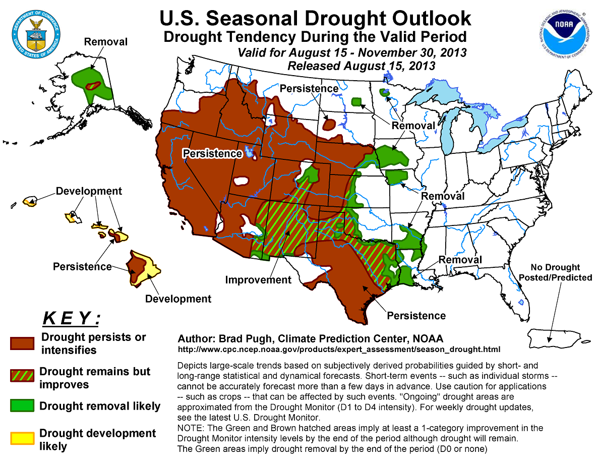
Since the summer drought of 2012 that affected much of the Great Plains, Mississippi Valley, and Corn Belt, the focus for drought generally shifted west during the past
six months. Drought recently reestablished itself across Iowa, northern Missouri, and the lower Mississippi Valley. According to the U.S. Drought Monitor, little to no
drought covers the continental U.S. east of the Mississippi River. Georgia and South Carolina were the wettest on record from February through July. The drought outlook
for August 15 - November 30, 2013 is based primarily on short-, medium-, and long-range forecasts, initial conditions, and climatology. Although rainfall associated with
the monsoon diminishes during September, improvement is forecast for parts of Arizona, Colorado, and New Mexico since the CPC September outlook favors above median
precipitation. Persistence is forecast across the extreme to exceptional drought areas from the Oklahoma Panhandle north to western Nebraska, while prospects for
improvement increase to the east across central Kansas, western Oklahoma, and northern Texas. Improvement is also expected for the short-term drought areas of the lower
Mississippi Valley, Missouri, and Iowa. In contrast, persistence is forecast for the intermountain West, Great Basin, and for ongoing drought areas along the West Coast
where the wet season arrives late in this outlook period. Drought is expected to gradually ease during the fall across Alaska, while drought persists or expands across the
Hawaiian Islands.
|
|
Tools used in the U.S. Drought Outlook (USDO) included the official updated CPC temperature and precipitation outlooks for
September 2013, the long lead forecast for September through November 2013, various short- and medium-range forecasts and
models such as the 5-day and 7-day precipitation totals from the Weather Prediction Center, 6-10 day and 8-14 day
forecasts, the NAEFS precipitation outlooks, the soil moisture tools based on the Constructed Analog on Soil (CAS) moisture,
dynamical models (CFSv2, NMME, and IMME), the 384-hour total precipitation forecasts from several runs of the GFS, the four-month
Palmer drought termination and amelioration probabilities, climatology, and initial conditions.
Improvement or removal, where existing drought is at the moderate (D1) level, is forecast for parts of Colorado, New Mexico, and Arizona. Although the monsoon
weakened recently after a robust July, the CPC September outlook indicates enhanced odds for above-median precipitation during September. In addition, the 6-10 day
outlook tilts the odds towards above-median precipitation across eastern Colorado. Since rainfall associated with the monsoon diminishes during September, forecast
confidence for widespread improvement across Arizona, Colorado, and New Mexico is tempered.
Forecast confidence is low across Arizona, Colorado, and New Mexico.
The drought outlook varies across the central and southern Great Plains due to differing signals across this geographic region. Enhanced odds for above-median
precipitation forecast by the CPC seasonal (SON) outlook supports improvement or removal of drought across central Kansas, west-central Oklahoma, and northeast Texas.
Short and medium range forecasts also indicate occasional rainfall across these areas. Improvement forecast across the Texas Panhandle and adjacent western Oklahoma
is based largely on rainfall during mid-August since precipitation tools on the monthly/seasonal time scale along with climatology offer a lack of clear guidance.
Uncertainty on the hydrological response to this rainfall, specifically across southwest Oklahoma, lowers confidence for the improvement depicted. Despite the median
positive change in soil moisture during SON across south Texas, the lack of a wet signal at any time scale favors persistence. Climatology including the negative
median soil moisture change during SON favors persistence across the exceptional drought areas of western Kansas and the Oklahoma Panhandle.
Forecast confidence ranges from moderate across western Kansas and the Oklahoma Panhandle to low across the remainder of Kansas, Oklahoma, and Texas.
Drought rapidly developed across the lower Mississippi Valley during the past month. Considering that this drought is short-term, drought could be eliminated in this
region with more frequent rainfall. The CPC 6-10/8-14 Day outlooks indicate increased chances for above median precipitation for this region. In addition, short-term
rainfall is expected across Louisiana. Another factor favoring drought removal for the lower Mississippi Valley is the increase in median soil moisture historically
during SON.
Forecast confidence is high for the lower Mississippi Valley.
Drought also recently expanded east across Iowa and northern Missouri. Since the CPC seasonal outlook calls for enhanced odds for above median precipitation in this
region, removal is forecast for these short-term drought areas. Farther north, model guidance indicates the potential for more than 1 inch of rainfall during the
next 10 days. Improvement is forecast for the small areas of drought across Minnesota and North Dakota.
Forecast confidence is moderate for Iowa and Missouri and low for North Dakota and Minnesota.
Drought is forecast to persist across the Great Basin, intermountain West, and northern half of the Rockies. Since dry weather is expected to be accompanied by above
normal temperatures during the next two weeks, drought may worsen across these areas. The CPC seasonal outlook tilts the odds towards above-median precipitation
across northern Idaho and Montana. However, precipitation later in SON is expected to be offset by the hot, dry weather during the remainder of August.
Forecast confidence is high for the Great Basin, intermountain West, and northern half of the Rockies.
In the areas of drought along the West Coast, the wet season usually doesn’t begin until late in the period, and historically 20% to 30% of the annual precipitation
total falls during September – November across northern California and southwest Oregon. Farther south, across central and southern California, only 10 to 20% of the
annual precipitation occurs during SON. Due to the relatively dry climatology until late in the period, persistence is forecast for the West Coast.
Forecast confidence is high for the West Coast.
Drought persistence and development, where abnormal dryness (D0) currently exists, is forecast for much of the Hawaiian Islands and is based on the seasonal outlook
calling for enhanced odds for below- median precipitation.
Forecast confidence in Hawaii is moderate.
Seasonably cooler temperatures during the fall are expected to increase chances for drought improvement and removal across Alaska. The CPC seasonal outlook calling
for equal chances of below, near, or above median precipitation decreases forecast confidence.
Forecast confidence in Alaska is low.
|


